
The water vapor in the lower left corner is over the Pacific with it concentrating at the equator. That concentrated water vapor is very warm as seen by pink and green on the radar. It traveled northeast from the equator and covered the east coast of North America.
The vortex north of Chicago is part of the cold air system coming from Canada. There is a clear division of water vapor STRUCTURES discerned from this satellite. Noted just north of the division of water vapor is a trough that mixes the two systems. It is approximately over West Virginia but that is not an exact location but an assessment.
There is a mixing, but, no trubulence at the mixing which I find strange for a meeting of a warm and cold front. Normally, that would explain thunder and lightning. The turbulence I observed with consistent rain occurs north of Chicago (more about that in a minute), but, as to the patter of SETS OF TWO thunder and lightning.
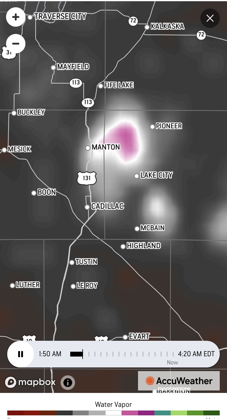
The turbulence seen in pink north of Chicago was over Grand Traverse County.
Currently over northwest Michigan it is raining. It is not torrential, but, steady. There are occasional burst of increased rain rates, but, mostly consistent. The rain bursts are not affiliated with the lightning.
The lightening accompanying this storm is reportable. The entire sky lights up in a blue color approximately the same natural color of the sky. It is preceded by a boom of thunder. It occurs in a set of two, one loud boom accompanied immediately by a bright blue flash and followed by a second boom with the same blue flash.
This dual flashing occurs between one minute to ten minutes apart.
At 4:25 am est the lightning has seemed to have stopped but the rain continues with slightly increased volume.
The rain is cold. The air temperature is 66 degrees Fahrenheit. The rain is colder than that.

The vortex near Chicago was over Grand Traverse County (it was a big system and not concentrated over one particular city). The pattern of the blue lightening was first boom (not rolling thunder) followed by a sky full of blue lightning, then immediately the second Boom (not rolling thunder) followed by a sky full of blue lightning. The PATTERN repeated itself variably between one minute to ten minutes apart.
I believe the water vapor was breaking down. H2O. If the very stable molecules met up with the perfect conditions to boil icy cold water within seconds, I believe the molecules broke apart. The boom was the explosion of a group of hydrogen atoms which would set off a blue lightening in the sky. The second boom was the other group of hydrogen atoms exploding followed by a flash of blue light.

Liquid oxygen in a beaker, (click here) showing its characteristic pale-blue color. Credit to U.S. Air Force photo
The lightening in this episode was very close to that color with the exception of it being an air mass.
I strongly believe, in contemplation of the sound patter, I am correct. I believe the mixing of the two different water vapor structures with movement near and over a body of lake water caused the destruction of H20 into two independent hydrogen atoms and one oxygen atom. There is absolutely nothing else that explains the color or the pattern. The PATTERN was consistent and exhibited in the same exact timing. There was no variability.
The spacing of the booms (not rolling thunder) I believe was due to the arrival of a water vapor pattern from a southeast location of the pink area of the vortex north of Chicago. I will illustrate that arrival pattern below.


One more image to go.

The State of Michigan has over one thousand lakes. It only makes sense this phenomena would show up clearly in this dynamic.
There is one more image that will help complete the clarity of this phenomena.

I believe I am correct. I simply don't see it any other way, unless scientists elsewhere can explain the repeating EXACT pattern.
I also believe this is a clear illustration of the impact of heat on our water supply at Earth's surface and how easy it is for conditions to rob Earth of it's water.
This phenomena is serious and needs to be addressed by a society that has the means to change it's greenhouse gas emissions as soon as possible. This occurred over the USA, not any place else. If the USA wants to keep it's water, the time to act to reduce and end emissions of greenhouse gases is now.