52 °F / 11 °C
Overcast
Humidity:
82%
Dew Point:
46 °F / 8 °C
Wind:
12 mph / 18 km/h from the NE
THE BAROMETRIC PRESSURE INDICATES CONCERNS, there is no 'rotation' to the 'feeder system' of the supercell. There is simply chronic bad weather. We have seen this before with the flooding of the Northeast when so many small dams were of concern.
Pressure:
29.98 in / 1015 hPa
Visibility:
10.0 miles / 16.1 kilometers
UV:
0 out of 16
Clouds:
Overcast 1000 ft / 304 m
(Above Ground Level)
THE INTENSITY OF THE CENTER of the Chicago Supercell is a bit blunted as the hot air from the equator is cooled when it finds land. It is the arctic coolness this supercell is feeding off bringing hot air from the equator to the region for heat transfer/conversion. The instability of the entire system cannot be understated. When these systems 'explode' it is severe and short in duration and as seen recently in tornadoes in Texas, fatal in nature. Doppler radar should prove valuable.
Be careful and good luck.
Monday, May 15, 2006
Floods force hundreds from homes in New Hampshire, Massachusetts, Maine
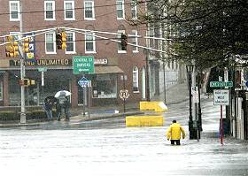
May 14, 2006. York Beach, Maine.
Torrential rain has prompted the governors of New Hampshire and Massachusetts to declare states of emergency, while Maine has declared an emergency in one county.
Caption :: Kayakers paddled down the streets of York Beach, where much of downtown was blocked off with police tape and firefighters in a boat shut off propane tanks. Water was high enough to cover an outdoor trampoline in Kennebunk, and powerful enough to wash an (That ends the caption as printed.)
By Francis X. Quinn
ASSOCIATED PRESS
7:34 p.m. May 14, 2006
AUGUSTA, Maine – Kayakers paddled down the streets of York Beach, where much of downtown was blocked off with police tape and firefighters in a boat shut off propane tanks. Water was high enough to cover an outdoor trampoline in Kennebunk, and powerful enough to wash an embankment out from under train tracks in Milton, N.H.
That's just a small sample of the damage parts of New England took thanks to a heavy, weekend-long rain spell. It flooded or washed away dozens of roads, sent dams overflowing and forced hundreds of people in southern Maine, northeastern Massachusetts and much of New Hampshire from their homes.
In New Hampshire alone, 67 communities reported road closings as of Sunday night, Gov. John Lynch said Sunday.
In some towns, police and fire crews used boats to rescue people from flooded homes and stranded cars. Others got around in kayaks.
“The town is cut right in half,” Andover, N.H., police Chief Glenn Laramie told WMUR-TV. “There may be a couple of days before the road opens back up.”
A creek that normally runs 60 yards from Tom Johnson's Salem, N.H., home was flowing into his basement, overwhelming a pump that handles 1,500 gallons of water an hour.
“My back yard is an ocean,” Johnson said. “It looks like the beach.”
Forecasters said the rain, which began Friday in many areas, could total 12 to 15 inches in southern New Hampshire by the time the storm passed late Sunday or Monday.
The National Weather Service said 5.12 inches of rain fell Saturday in Concord, N.H., 3½ times the previous record for the date. Boston had picked up 6.34 inches of rain in 30 hours by Sunday morning, and Andover, Mass., collected 9.8 inches over the same period.
Eastern Massachusetts was forecast to get another 5 inches of rain by Tuesday.
“This is the tip of the iceberg,” state emergency management spokesman Peter Judge said. “It's going to get worse.”
The governors of the three states declared states of emergency, clearing the way to activate National Guard troops or seek federal help if needed.
“We don't know how much damage we have until the water goes down,” said Charles Jacobs, assistant to the director of the Maine Emergency Management Agency.
There were no reports of deaths due to the heavy rains, seven months after flooding in New Hampshire killed seven people, carried off homes and washed away miles of roads down to bedrock.
Some residents of Milton evacuated after the National Weather Service warned that an upstream dam was in danger of failing, potentially unleashing a 10-foot wall of water. The state Office of Emergency Management said at least a dozen dams were being closely watched.
People in several New Hampshire towns were ordered to leave their homes and others did so voluntarily. About 100 residents in Wakefield were ordered out, and about 50 nursing home residents were evacuated in Hooksett, which the local emergency management office said was essentially closed because so many roads were flooded.
Because of high water, officials in Concord had to close the Concord Steam plant, which provides heat to many buildings in the city. Overnight temperatures were dipping into the 40s.
In Massachusetts, cars were pulled from flooded streets in downtown Peabody, about 20 miles north of Boston, and about 300 people were evacuated from an apartment complex for seniors. Businesses stacked sandbags at their doors, trying to prevent damage from water that at one point rose to waist-deep.
“Everybody's trying to get their things packed and get out,” said 84-year-old Ann Smith, a resident of the complex. “It makes you nervous, when you're older.”
About 150 residents in Melrose, Mass., had to leave their homes after sewage lines were overwhelmed, backing up into houses, said Gov. Mitt Romney.
More than 50 homes in Sanford, Maine, and several in Kennebunk also were evacuated, state officials said.
Several shelters were opened up across the affected region.
Esther Gibely, one of about 30 people who took shelter at a Peabody high school, said her home was so flooded her clothes, bureaus, and a cedar chest were floating in several feet of water.
“I have no heat, I have no hot water, and my cellar is flooded up to its tippy top,” Gibely said. But she found one bright spot: the National Guardsman who picked her up in a military Jeep when the water got too high.
“That was a joy ride. That fella, he was cute,” she said.

The Center of the Supercell is gaining intensity near Chicago (Please click on)
Today...Mostly cloudy with occasional rain or drizzle likely. Highs in the upper 50s. Northeast winds 10 to 15 mph becoming north. Chance of measurable precipitation 60 percent.
Tonight...Cloudy. Some light rain or drizzle again likely. Lows in the upper 40s. North winds around 10 mph. Chance of measurable precipitation 60 percent.
Tuesday...Mostly cloudy with a 30 percent chance of light rain. Highs in the lower 60s. North winds around 10 mph.
THE CENTER OF THE SUPERCELL IS JUST WEST OF CHICAGO. IT IS RELATIVELY BENIGN AT THIS TIME ...
... BUT...
... has a feeder system that is bringing more heat and intensity to it. It bears watching ! Kindly CLICK ON the link with this title to view satellite AND kindly note the western side of the Supercell. Thank you.
UNISYS Infrared Satellite 12 hour loop

May 14, 2006.
Supercell forming near Chicago.
ALERT
This may be a very dangerous system and deems close watching. It has many dynamics and none of them are friendly. The Northeast of the USA is getting significant rain and southern Texas is receiving severe flash floods. I haven't been able to find news information about northern Mexico but it can't be good.
KINDLY pay attention.
Update 1: 2 Teens Rescued From Texas Flash Floods
By The Associated Press , 05.14.2006, 10:16 PM
Most Popular Stories
A strong line of storms with heavy rain, large hail and high winds moved through portions of Texas on Sunday, forcing a dramatic rescue of two teenage boys caught in a flooded drainage ditch.
The teens had stopped to help the driver of a car swept off the road by flash flooding and into a ditch when they were dragged under by the strong currents.
One was sucked into a 70-foot-long drainage pipe and spat out on the other side of the road, said Fire Chief Glen Arthur in Hewitt, a small town just south of Waco.
Firefighters had to pry the other teen out after he became trapped under the vehicle.
The teenagers, the woman driving the car and a firefighter were taken to a local hospital and later released, said Arthur, who would not release their names.
Arthur described the current in the flooded ditch as "overwhelming," sucking the boots and socks off of one of the firefighters.
The National Weather Service said radar indicated 3 1/2 to 4 inches of rain fell in the Hewitt area.
There were no immediate reports of any other injuries from the storms.
A tornado west of Florence in Williamson County damaged a house and tore off a barn roof, said Detective John Foster with the Williamson County Sheriff's Office.
Hail the size of ping-pong balls smashed windows in Kerrville. To the east, Austin and San Antonio escaped the worst of the storms, said Pat McDonald, a National Weather Service meteorologist in New Braunfels.
Storms also pounded Houston, dropping as much as one inch in 15 minutes, said Kent Prochazka, a weather service meteorologist in Houston.
Subscribe to:
Posts (Atom)