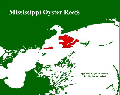
The Oyster Reefs of the Gulf Coast Full funding is needed for full return of the offshore wetlands of the Gulf Coast
 The Gulf Coast Economy has bearly begun to return.
 April 3, 2006. 9:00 AM. Being a climate watcher can be rough. One day/week it looks like there is a shift and then there is a increase in the component one wished was clearing up. It happens frequently but then what is revealed during those times is the fact Earth is still holding on to the dynamics that provide life to this planet. I worry sometimes that irreparable damage is being done that we will be more profoundly sorry for than any thus far; then; that small turn to sanity as we understand it reveals Earth's dynamics that speaks to it's biotic longevity. Let's hopes that continues. The USA needs to stop polluting all dangerous gases including high levels of carbon dioxide.
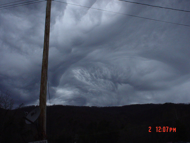
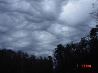 April 2, 2006. Oak Ridge, Tennessee.
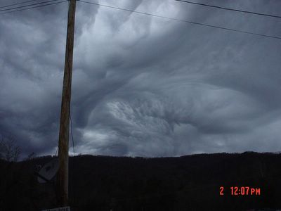
 April 2, 2006. Oak Ridge, Tennessee.
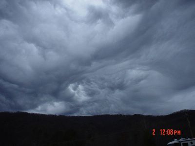
 April 2, 2006. Oak Ridge Tennessee.
 April 2, 2006. The River Charente, Angouleme, France.
 April 2, 2006. Angouleme, France.
 April 2, 2006. Angouleme, France.
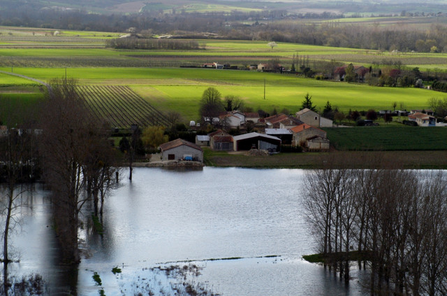
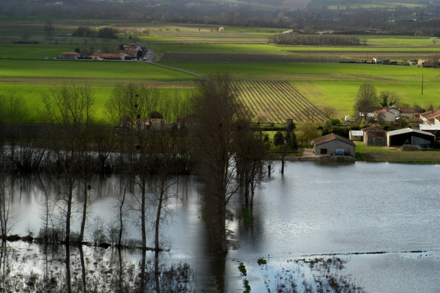
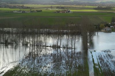
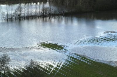 April 2, 2006. The River Charente, Angouleme, France at flood stage.
This is so apropos. Click on the above link.Severe thunderstorms, tornadoes miss county
Despite alert, only small hail reported in Columbia
By JENNIFER POWELL
April 3, 2006 Workers at the 911 Joint Communications Center were on high alert Sunday afternoon as they braced for severe weather to hit central Missouri, but the worst of the storms by passed Boone County.The National Weather Service forecasted severe thunderstorms with the possibility of hail the size of baseballs and tornadoes across Missouri and Illinois through Sunday evening. “We are constantly monitoring the weather,” on-duty weather watch coordinator Suzanne Fred of the 911 center said. “Usually when we see severe weather developing around the Sedalia area we start preparing and notify personnel to be available to come in.”Fred said only two additional people were called in because of the weather threat. Others were on stand-by, she said, but it was not necessary to call them. .At 3 p.m. Sunday, there were numerous severe thunderstorm warnings posted north, east and south of Columbia, from Springfield through Lake of the Ozarks and into northern Missouri. Most of the preliminary reports from those storms were limited to hail.Downtown Columbia was struck by hail at 3:44 p.m., but it was short-lived. There were reports of hail throughout Boone County, Fred said, but “99 percent” were for pea-sized hail. There were a few reports of small hail and one citizen even reported larger hail, “possibly baseball size” in the area around Nifong Boulevard in south Columbia, Fred said.
By late afternoon, the 911 center had no reports of damage or injuries in Boone County.There was, however, one road closing. A tree blocked one lane of Missouri 163, by Pierpont, just south of Columbia near Rock Bridge Memorial State Park. A telephone line was also affected, but there was no outage.Several tornado warnings were issued as the storms approached the Missouri-Illinois border, and far eastern Missouri remained under a tornado watch until 10 p.m. Sunday. By 6 p.m., the Weather Service reported tornado damage to buildings one mile north of Clarence Cannon Dam in Monroe County.
 March 13, 2006. 0815z. This is the vortex that caused tornadoes as well.
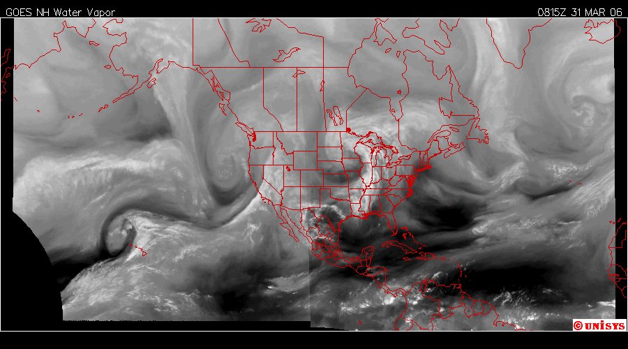
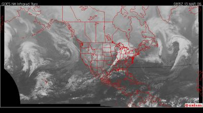
 March 31, 2006. 0815z. The series of vortices coming off the equator and rolling across the face of the continent.
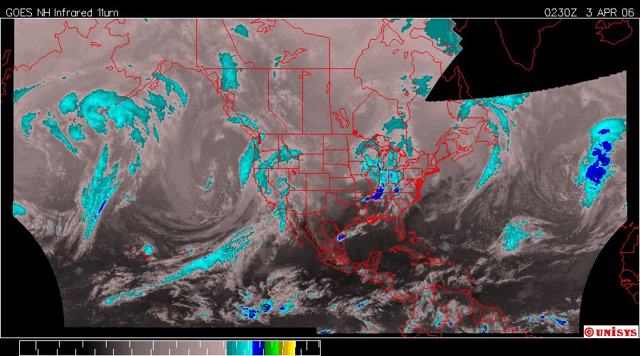
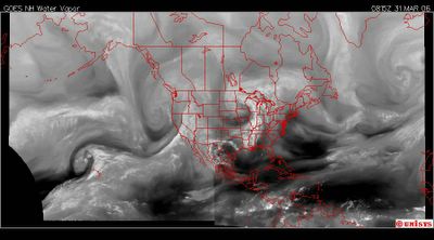
 April 3, 2006. 0230z. Infrared satellite. There is a huge vortex off the west coast of California. Sometimes they resolve their energy overload as tropospheric tornadoes over water. I doubt if that will be the case with this one, as it has a 'feeder' system connected to the equator.
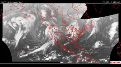
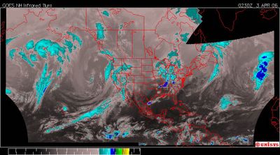 April 3. 2006. 0230z. Enhanced infrared.It still has the 36N delineation noting the intensity of the contrast between air masses.
Kindly note, KILLER thunderstorms. Thunderstorms. Not major alarming events. Thunderstorms. Some are accompanied now with tornadoes. Hail is always in the equation with tornadoes. Hail will kill people. You get hit with a golf ball sized piece of ice and see how you feel. Then multiply that by hundreds more.
I. Told. You. So.
I also told George Bush and the EPA so, exactly THREE years ago !
YEARS of DAILY warnings to anyone and everyone I could, including the Yahoo Message boards when there were no other. Then the CNN message boards. Then The New York Times message boards. A website with testimony. How much does anyone with a brain need to realize there has to be drastic measures to cut back CO2 in the troposphere. Every year, I have seen this grow worse and worse and worse. It's not going to get better until the USA, the worst war monger on Earth STOPS it's insane pollution of the troposphere.
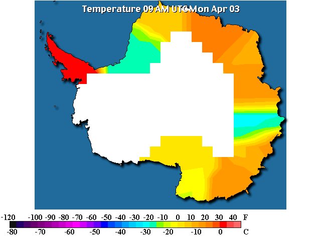
Not to diminish what the Kyoto Protocol is doing. I sincerely believe there is an impact. It was seen recently involving Australia, which is also a terrible polluter. Antartica last week showed signs of some 'real' freezing temperatures approaching winter in the Southern Hemisphere. The nations involved with Kyoto are making a difference and Britain is one of them.
Thunderstorms, tornados kill at least 15 in Tennessee, Missouri,Illinois
The Associated Press (apwire)
KRISTIN M. HALL
NEWBERN, Tennessee
Severe thunderstorms packing tornadoes and grapefuit-sized hail left a path of destruction across six Midwest states, killing at least 15 people in Tennessee, Missouri and Illinois, officials said.
The Sunday storms caused a clothing store to collapse in Illinois and overturned mobile homes in several states. Power was knocked out to at least 300,000 customers in Illinois, Missouri and Indiana.
Half a dozen tornadoes and grapefruit-sized hail were reported in northeast Arkansas, where about half of the town of Marmaduke was evacuated because of gas leaks and other concerns,police said.
In Tennessee, eight deaths were reported near Newbern in Dyer County and three in Bradford in neighboring Gibson County, said Kurt Pickering, spokesman for the Tennessee Emergency Management Agency.
A twister carved a path through homes near the Jimmy Dean Foods plant north of Newbern, where several victims died. The plant, which makes breakfast sausages and other food products, also sustained some damage, a security guard said.
In Fayette County east of Memphis, a home was thrown from its foundation, a grain silo was destroyed and a mobile home was overturned, The Tennessean reported.
The National Weather Service in Memphis preliminarily reported tornadoes in five counties in West Tennessee _ Dyer, Carroll, Haywood, Gibson and Fayette _ and officials said the storms caused extensive damage to buildings.
Strong winds were blamed for at least three deaths in Missouri. A 42-year-old man was killed when winds knocked over his mobile home near Circle City, Stoddard County Sheriff Carl Hefner said. A second death was reported in Pemiscot County, the state emergency management office said, but no details were available.
Another man was killed when a tree fell on him as he walked along a trail in Castlewood State Park in St. Louis County, a spokeswoman for St. Louis County police told the St. Louis Post-Dispatch.
A state of emergency was declared in the southeast Missouri city of Caruthersville after a tornado caused heavy damage there. Details of the damage were not available.
High winds caused an Illinois clothing store to collapse east of St. Louis, killing a 54-year-old man, police Capt. Nick Gailius said.
Emergency crews were searching the rubble for any additional victims, their progress slowed by a gas leak, Gailius said. Others were injured in the collapse, he said.
A Kentucky county declared a state of emergency early Monday after rescue workers struggled to get to rural areas because of power lines and trees that blockedroadways.
''We're concerned that there's a lot of hidden back roads that are hard to get to,'' said Matt Snorton, Christian County's emergency management director.
He said at least three dozen people were injured in what officials believe was a tornado. At least 30 people sought medical care at the emergency room in Hopkinsville, he said, and a couple were considered seriously injured.
http://english.ohmynews.com/ArticleView/article_view.asp?no=283432&rel_no=1
Storms, tornadoes kill 19 across Midwest
Updated 4/3/2006 5:55 AM
Emergency personnel work to stablize the arm of a victim with a makeshift sling as others try to comfort a victim who is trapped after storms struck Marmaduke, Ark., Sunday.
By Oren Dorell, USA TODAY
Severe storms and tornadoes raced across Midwestern states Sunday, killing at least 15 people in west Tennessee, and four others in Missouri and Illinois, emergency officials reported.
Several homes north of Dyersburg, Tenn., were flattened in the storms, said Tommy Gibbons, emergency management director for the town.
"We had a lot of destruction up here," said Gibbons, who could not confirm if a tornado touched down.
In Missouri, severe winds were blamed in the deaths of two people in Circle City and Ballwin, police said. In Illinois a man was killed in the collapse of a store in Fairview Heights, police Capt. Nick Gailius said.
Dozens of people were injured when tornadoes and winds from the same weather system tore off roofs, uprooted trees and knocked down utility poles in a swath through Iowa, Illinois, Indiana, Ohio, Arkansas and Tennessee.
Video: Twister damages homes south of IndianapolisMore than 40 people were treated in the Arkansas town of Marmaduke, where one of six confirmed tornadoes in that state touched down.
In Illinois, winds of 80 mph tore roofs off dozens of homes and businesses and at least one elementary school, said Ernie Goetsch, meteorologist in charge at the National Weather Service office in Lincoln, Ill.
In downtown Indianapolis, television station WTHR showed fans scrambling as tornado sirens wailed and rain whipped the streets after a free concert that was part of the NCAA's Final Four weekend.
For the second time in three days, thunderstorms and tornadoes were reported in central, eastern and southern Iowa.
http://www.usatoday.com/weather/stormcenter/2006-04-03-severe-storms_x.htm?POE=NEWISVA
High winds, storms race across area
Indianapolis, April 2 - Severe thunderstorms laden with possible tornadoes raced across Indiana on Sunday night, rocking downtown Indianapolis as thousands of fans departed a free John Mellencamp concert that was part of the NCAA's Final Four weekend.
The storm hit the downtown area just as the free concert was ending. Fans rushed for cover as storm sirens sounded.
National Weather Service personnel took shelter for about 10 minutes as high winds kicked up debris against the agency's building at Indianapolis International Airport, said meteorologist John Ogren.
Weather service radar tracked a powerful thunderstorm with a possible tornado through downtown Indianapolis, he said, but officials would not be able to confirm if the storm was a tornado until they inspect damage on Monday.
http://www.wthr.com/Global/story.asp?S=4715474&nav=9Tai
Severe thunderstorms, tornadoes move through Kentucky
LOUISVILLE, Ky. Severe storms and several tornadoes have ripped through western and central Kentucky.
Trees, power lines and even a few buildings are down.
The National Weather Service has reported widespread damage to houses and buildings from straight-line winds and fallen trees.
The National Weather Service says tornadoes likely touched down in Logan, Warren, Christian, Hancock and eastern Jefferson County, though nothing was confirmed because it was dark.
No deaths or major injuries were reported as of Sunday night.
The storms came in two waves, starting yesterday afternoon. The more severe storms in the second wave had mostly passed through by late last night.
Officials predict there will be plenty of clean-up work today.
http://www.wkyt.com/Global/story.asp?S=4715416&nav=menu181_2
Small tornado damages hotel, airport
TULSA, Okla. Authorities say a small tornado touched down in northeast Tulsa, causing damage at Tulsa International Airport, a neighboring hotel and to dozens of vehicles.
EMSA officials say four people at the hotel reported minor injuries in last night's storm, but none of them was taken to a hospital.
The small twister briefly touched down just south of the airport, near Oklahoma Highway 11 sometime between 11:30 P-M and midnight Saturday. National Weather Service meteorologist Steve Piltz says the tornado stayed on the ground for a few seconds and no warning was issued beforehand.
Airport spokeswoman mary Smith says the tornado damaged some aircraft and left minor damage to the terminal.
Hotel spokesman Kevin Roberts says the roof of the Radisson Inn-Tulsa Airport was ripped from several rooms, and as many as 200 guests had to be moved to other hotels.
The Radisson has been shut down, and Roberts is unsure when it will reopen.
http://www.kten.com/Global/story.asp?S=4715421
Tornado, hail, winds lash state; man killed
The Associated Press
Published April 3, 2006, 12:42 AM CDT
High winds, hail and at least one tornado blew across Illinois on Sunday, damaging homes and businesses, knocking out electrical service to thousands and killing a Downstate man.
In the Chicago area, the storms had knocked out power to nearly 9,000 Commonwealth Edison customers as of midnight, with about 5,600 customers without service in the city, ComEd spokesman Luis Diaz said.
Many of those areas reported pea-size hail and drenching rains, said Bill Wilson, meteorologist for the National Weather Service in Romeoville.
Meanwhile, officials from more than a dozen state agencies gathered at the State Emergency Operations Center in Springfield to assess damage wrought by the line of storms.
A tornado touched down in Fairview Heights, east of St. Louis, killing a man when a clothing store collapsed in high winds, according to police.
Police are canvassing the community to determine the extent of the damage, authorities said.
A trailer park on Springfield's northeast side sustained damage from strong winds, Sangamon County Sheriff Neil Williamson said.
In Taylorville, southeast of Springfield, Acting Police Chief Rohn Burke said high winds snapped tree limbs and knocked down power lines throughout the area during the brief storm that hit the area around 6:15 p.m. and lasted about 20 minutes.
There were no confirmed tornado sightings or touchdowns, but one report--unconfirmed as of about 8:45 p.m.--recorded winds in excess of 100 m.p.h., Burke said.
There were no reports of injuries.
http://www.chicagotribune.com/news/local/chi-060403weather,1,1730313.story?coll=chi-news-hed
Possible tornado rocks downtown Indianapolis
CHARLES WILSON
Associated Press
INDIANAPOLIS - A violent storm, possibly a tornado or series of twisters that touched ground as many as eight times, caused widespread property damage and at least nine injuries in central and southern Indiana, a state emergency spokesman said Monday.
The storm punched through downtown Indianapolis on Sunday night just after thousands of people had left a John Mellencamp rock concert on Monument Circle, blowing windows out of a bank office tower and sending fans scrambling for cover.
The free concert was part of the NCAA men's basketball Final Four festivities, which wind up with the championship game between UCLA and Florida at the nearby RCA Dome on Monday night. There appeared to be no damage to the Dome, said Bob Demuth of the State Emergency Management Agency.
http://www.fortwayne.com/mld/newssentinel/news/local/14248537.htm
Tornado touches down near Riverside
Reports indicate several tornados struck Iowa and Illinois on Sunday. There was property damage, but there were no injuries reported.
A tornado reported touched down outside Riverside at 5:14 p.m. close to Highway 218 in Washington County.
Other reports came from Van Buren County with strikes at 4:15 p.m. and 4:30 p.m. Those reportedly damaged a home and destroyed a barn. A twister struck Fairfield and to the south at about 4:30 p.m., destroying a tree, mailboxes and a barn. There were three reports of tornados in western Illinois between 5:16 and 5:30 p.m.
Tornado warnings and severe thunderstorms covered much of Eastern Iowa on Sunday afternoon and evening,
The National Weather Service will investigate today, and assess the severity of the storms. The severity is determined by wind speed, damage and the stability of structures, if structures were destroyed.
http://www.press-citizen.com/apps/pbcs.dll/article?AID=/20060403/NEWS01/604030309/1079
Weather Advisory: Tornado watch active for WNC
published April 3, 2006 6:00 am
Reader Feedback: Comment on this article Register hereThe National Weather Service office has released a special weather statement affecting Buncombe, Haywood, Madison, Jackson, and Swain County.
Strong thunderstorms are affecting the northern part of the Smoky Mountains and surrounding areas.
At 4:05 am
National Weather Service radar indicated strong thunderstorms across the northern part of the Smoky Mountains, moving east at around 40 mph.
Through 5 am
These storms will move off the Smoky Mountains over the Pigeon River gorge and Newfound Mountains, and approach the lower French Broad Valley.
Gusty winds of up to 50 mph with hail up to one half inch diameter, frequent cloud to ground lightning, and brief periods of torrential rainfall can be expected in these areas. These storms are being closely monitored for possible warnings.
A tornado watch remains in effect for the area until 11 am for the following counties:
Alexander, Avery, Buncombe, Burke, Caldwell, Catawba, Cherokee, Clay, Cleveland, Graham, Haywood, Henderson, Iredell, Jackson, Lincoln, Macon, Madison, McDowell, Mitchell, Polk, Rutherford, Swain, Transylvania, Yancey
http://www.citizen-times.com/apps/pbcs.dll/article?AID=/20060403/NEWS01/60403001/1094
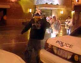 April 2, 2006. Indianapolis, Indiana. Caption :: Fans run for cover as the storm hits near the end of the Mellencamp concert.
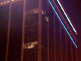
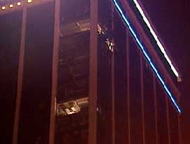 April 2, 2006. Indianapolis, Indian.Caption :: Several windows were blown out of the Regions Bank Tower.
History has nothing to do with the current weather pattern. When this F5 occurred fifty years ago there weren't chronic vortices or recurrent Cat 5 storms in the Caribbean and Gulf of Mexico.50th Anniversary of F5 Tornado By: Keith Thompson, Weather First Chief MeteorologistApril 3, 2006 - 12:36AM
Today marks the 50th anniversary of a deadly F5 tornado in West Michigan. Named the Standale tornado, it ripped a path though eastern Ottawa County from Hudsonville to Standale. 17 people were killed by the twister. The tornado is one of only two F5 tornadoes to be documented in Michigan. The other was in Flint in 1953. An F5 tornado is the most powerful of all tornadoes. They are quite rare. Of the many thousands of tornadoes that have been documented in the United States since 1950, only 51 have been rated an F5. Speaking of tornadic weather, according to the Storm Prediction Center, there were dozens of tornadoes reported Sunday -- occurring mainly in Illinois, Arkansas and Tennessee. There were reports of a tornado in Indianapolis. Several buildings in downtown Indianapolis were damaged by severe weather. The Storm Prediction Center collected nearly 600 reports of large hail, high winds and tornadoes from Sunday's outbreak. Fortunately, the storms lost much of their power by the time they moved through West Michigan early Monday morning.