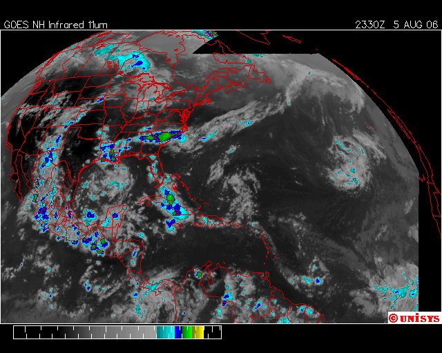
August 5, 2006. 2330z. UNISYS Enhanced Infrared Satellite.
 I know I am going to be writing about something few will understand but unless 'I go there' then no will understand where 'I am coming from.'
Heat Budgets. I am completely convinced the universe is finite. I believe energy is as well and that includes the energy that dominates Earth's troposphere. It comes as benign sunlight on a completely different wave length than the 'heat' of which is necessary to keep Earth warm enough to live on.
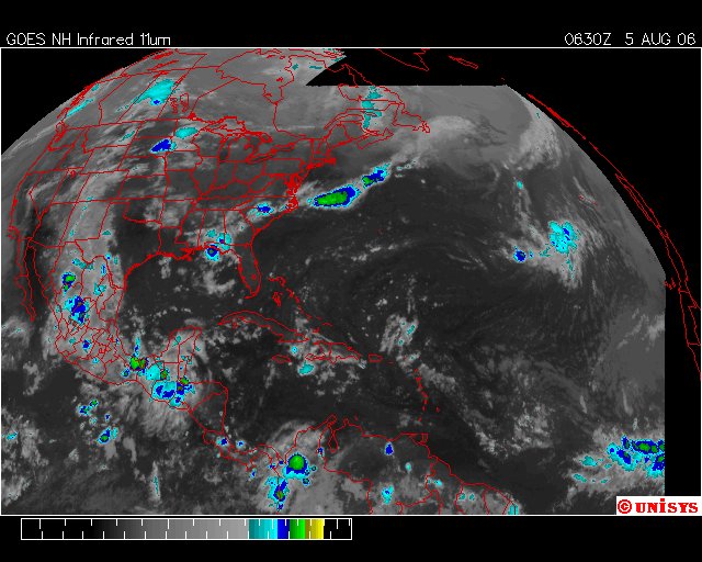
The heat 'wave length' of Earth is infrared. That heat is generated after the Sol's (The Sun) light reaches Earth. If Earth did not convert Sol's light into a wavelength that brings heat than we would not have a planet hospitable to life. I am going to digress to an earlier satellite and yes I will do 'Saturday Night.'CONTINUED FROM SATELLITE TIME OF 0630z.Now, to realize, as Chris 'lost' it's impulsion if you will. As the night time hours stopped fueling a storm now over landmass where it would find a 'drag' on it's center; the center pressure started to rise and hence the velocity of the 'tropical storm' then to become 'tropical depression' caused a transfer of energy enough 'back' to the troposphere. That transfer of energy/heat back to the troposphere along with another day of full sun enhanced the remaining dynamics including the vortex from Mexico to the Arctic Circle. When a storm like 'Chris' starts, it is because the solar radiation transformed by Earth and TRAPPED under a thick blanket of carbon dioxide has no place to go but to find relief in a delivery system that will transfer calories to the oceans. That is what any of these major storm do. When Chris lost it's 'central pressure' it wasn't finished with it's business. That was evident because the 'cloud mass' as it appeared on the satelites remained in a formation. More diffuse now, but, still not completely gone from being able to recognize it.On this satellite view, one might note also the extreme increase in the storms all along the vortex. As a matter of fact the "Mexican Vortex" has increased it's reach and ability to distribute heat all the way into the Gulf of Mexico. Now, when one looks at the vortex over Mexico, it's center is still over the Yukatan but has additional reaches to the Arctic Circle. The one it exhibited before over Canada, but, now there is one that reaches to the Greenland Ice.Also to be noted is the 'Chris System' that still remains over the Islands, including Cuba. (Off topic - Fairwell Fidel.) It is this 'cloud mass' over the islands that causes me pause to believe 'Chris' is completely dissipated. As a matter of fact if one looks at all the satellite pictures above 'Chris' can be noted just south of Port-Au-Prince, Haiti. As a matter of fact the 'storm' that was Chris, in my opinion, has straddled both sides of the Island, with one dynamic reaching a conclusion just west of Jamaica and the other remaining very stormy just north of Salina, Cuba and west of Loggerhead Point, Andros Island.To me 'Chris' is still very much alive. It's dissipation is not complete and the storm now brewing at the Tropic of Cancer and west of the Bahamas is not very far from where Katrina first became a Tropical Depression with 30 knot winds. To me 'Chris' is a system that sends heat either into the ocean as a storm with an 'eye/central pressure' or as storm that will dump huge amounts of heat on terra firma and a storm that will cause people a great deal of distress wtih flooding and dangerous weather conditions.
end of entry