ZOOS tomorrow morning.
Nite for now.
Monday, August 28, 2006
1 Man Dies As Tornadoes Hit Minnesota
Deadly storms swept across the northern Plains, bringing tornadoes that ripped roofs off houses and hail that smashed car windshields. One man was killed when a tornado hit his home in Minnesota on Thursday, and in Wisconsin, lightning apparently killed a dozen cows and struck a woman as she left a supermarket.
Twisters, heavy rain and hail as big as grapefruit also struck the Dakotas, stripping trees of their leaves, and power was knocked out around the region.
In Nicollet County, Minn., a tornado ripped roofs, fronts or sides from farm homes along a 12-mile stretch of highway between Nicollet and St. Peter. Powerline poles lay along the road, and some treetops were sheared off.
Mary Rahm, 22, saw the tornado dip down twice from the clouds before it hit the ground. That's when she grabbed her newborn baby and ducked under a desk.
"My 5-week-old son just made it through his first tornado," Rahm said. "This is wicked."
A tornado in nearby Kasota killed a man who was trapped in his home, said Tom Doherty, chief sheriff's deputy in Le Sueur County.
Several residents were treated at hospitals for broken bones and other non-life-threatening injuries.
An earlier line of thunderstorms dropped hail as large as softballs in several communities, smashing the windshield of a New Prague fire truck. In Northfield, hail damage to 11 police squad cars forced officers to borrow vehicles from the sheriff's office.
At least a half-dozen tornadoes raked across central South Dakota, destroying farm homes and damaging power lines. Jeff Miller said the storm looked like a blanket as he watched from his mother's home near Wolsey. "
I was worried about whether I was going to be here today," Miller said Friday, surveying the debris.
"That used to be a barn," he said.
Neighbor Bill Timm lost nine buildings, including two houses.
"They're not flattened, they're gone," said Kristi Brakke, Timm's sister.
North Dakota had heavy rain, funnel clouds, and grapefruit-sized hail. "It didn't really hail all that much, but what it did hail was big," Stanton City Auditor Rick Honeyman said.
In Wisconsin, a 43-year-old woman was knocked to the ground while carrying an umbrella and groceries through a parking lot in Waukesha County.
"I don't remember hearing thunder or seeing lightning or anything," Kelly Owen told WISN-TV in Milwaukee. "It's the weirdest sensation."
Lightning also killed a dozen cows on a farm in Marshall, and strikes were suspected of starting fires at a seniors' apartment complex in Kenosha and a home in Cottage Grove home.
More rain was expected Friday in Michigan and the upper Mississippi Valley southwest to Kansas and Oklahoma.
August 24, 2006.
Wolsey, South Dakota.
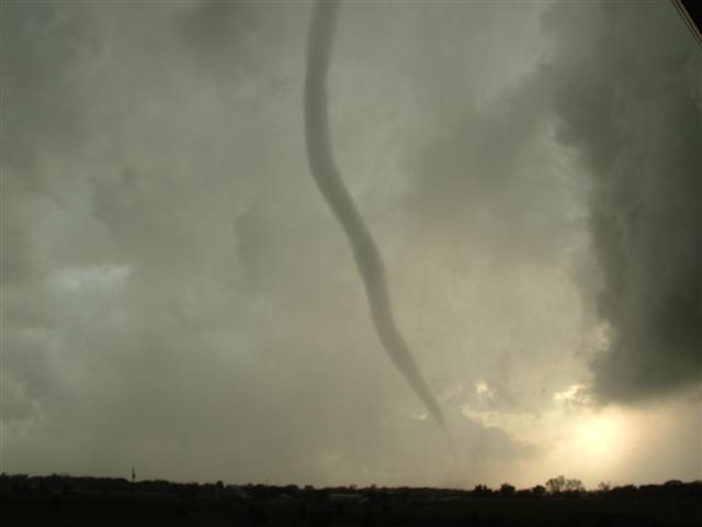
This tornado is more than just trouble, it reveals to me a trend in the greater density of the vorticities now in the troposphere. This is the first time I have noted a tornado ATTACHED to a greater voticity.
Caught on home video, "It's a monster"
http://www.kare11.com/news/news_article.aspx?storyid=133168
This video report is completely indicative of what I have been noting as a NEW PHENOMENA in this Human Induced Global Warming troposphere. These storms are sudden and have incredible impact including huge deluges of rain that DO NOT contribute to releaving drought, but, serve as overland flow that causes flooding.
Kindly pay attention to his observation skills and his ability to rely it to others. This 'nerves of steel' allow him to deliver a very valuable message.
http://www.kare11.com/video/player.aspx?aid=32477&bw=
This video clip shows the benign way in which a tornado APPEARS to start. Tornadoes aren't actually seen UNTIL they start to kick up debris that combines with the cloud humidity. As a matter of fact this video is quite extensive in noting the clouds on the horizon beyond the tornado and the velocity they are moving. This tornado was also a quickly developing vorticity in that by the time the end of the tape is noted, the vorticity actually is spinning so fast it 'deposits' pieces of itself on the ground. The 'drag' by the ground/Earth/land doesn't slow down the vorticity at all, it simply breaks off and continues. This is possible because the vorticity is actually a ground manifestation of a much higher velocity that extends well into the troposphere. The tornado is supported from a higher density than just what is evident within a doppler tracing as well. It's an excellant video. I tells a story I could only hope to see.
http://www.kare11.com/video/player.aspx?aid=32479&bw=
The video shows what I dread. It is a vorticity without a focal point. It literally is the heat coming out of the sky and 'landing' inadvertently anywhere it finds it's dynamics satiated. As a matter of fact this type of vorticity doesn't have satiation. Noted at the trailing edge of this vorticity is a higher density of debrise mixed with cloud mass. THAT if the vorticity of the heat of the upper levels were less would be a focal tornado. But do to the support from the upper troposphere the focal point is swallowed up with satiation. It is a dangerous storm. My concern is that this high velocity will be an increasing trend ESPECIALLY if there is an abatement of 'heat transfer' into the oceans by hurricanes.
http://www.kare11.com/video/player.aspx?aid=32480&bw=
I really don't see these manifestations any different from that of hurricanes IN THAT there is constant heat energy that needs relief under carbon dioxide density of the troposphere. That energy ONLY diminishes for Earth as the carbon dioxide layer lessens. With a less dense carbon dioxide layer, the infrared heat retained by Earth is less and diminishes these storms. My concern is that these storms are the trend and not just a peculiarity from time to time.
These are very high velocity storms. They literally overrun their own ability to maintain contact with the ground. Really good video. This man is absolutely correct in being 'flat out scared' it is an instinct to be trust and respected. Just don't run toward the storm, okay?
http://www.kare11.com/video/player.aspx?aid=32559&sid=133212&bw=
Severe storms here aren't over yet
Flood advisory issue for three area counties
By Bill Novak
Severe thunderstorms slashed across south central Wisconsin Wednesday night, the first wave of bad weather expected to continue to hammer the area today and Friday.
"The next 36 hours will be fun," said Weather Central meteorologist Bill Romine this morning, after a long night of spectacular thunder and lightning, torrential downpours, big hailstones and one unconfirmed tornado in Sauk County.
The National Weather Service issued a flood advisory today for Dane, Columbia and Rock counties in south central Wisconsin, as storm runoff had the potential to cause flooding of small streams and creeks, highway underpasses and other low-lying areas.
While the storms were loud and bright Wednesday night, very little damage was reported to authorities in the Madison area. But American Family Insurance spokesman Steve Witmer said hail damage claims are starting to come in.
"We've had a couple hundred property claims so far today," Witmer said, "with 100 automobile claims from the Tomah area alone."
http://www.madison.com/tct/news/index.php?ntid=96176&ntpid=1
Tornadoes tear through southern counties
Storms damage buildings, cause mostly minor injuries but no deaths
BY TAD VEZNER
At least three tornadoes whipped through rural areas of southern Minnesota on Thursday, resulting in dozens of injuries as well as damaging buildings and downing power lines.
The National Weather Service confirmed the first two tornadoes touching down about 5:45 p.m. several miles west of St. Peter, near the town of Nicollet, in Nicollet County. The tornadoes traveled east, passing just south of St. Peter, and minutes later were reported to the southeast of St. Peter, in Le Sueur County.
Rain wrapped the funnels, making them difficult to see before they struck, the NWS reported.
A third tornado touched down at 7:14 p.m. near Mantorville, threatening Dodge and Olmsted counties.
Other tornadoes were seen in Kasota, Kilkenny and Waterville, the NWS reported.
http://www.twincities.com/mld/pioneerpress/news/local/15354971.htm
Tornadoes Hit Northern Ind., Minn., Causing Damage and One Death
August 25, 2006
Severe thunderstorms and tornadoes swept off Lake Michigan Wednesday evening, downing trees and power lines and causing some injuries in Indiana and killing one resident in Minnesota.
In LaPorte County, Ind., 911 Assistant Director Beth West said some injuries were reported in the county, but she did not have any details.
Heavy damage was also reported at a boat show scheduled to begin Thursday at the Washington Park Marina on Lake Michigan, police said. The News-Dispatch reported vendors setting up for the show were hit hard and some docks were moved, but most of the yachts and boats were safely harbored in nearby Trail Creek.
Instruments with the U.S. Coast Guard measured winds of up to 92 mph.
http://www.insurancejournal.com/news/midwest/2006/08/25/71715.htm
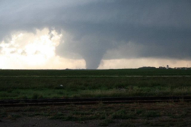
Tornadoes ruin farm
August 24, 2006.
Wolsey, South Dakota.
Photographer states :: on 8/24 2006, wolsey SD, in Beadle Co. Tornado on ground
http://www.plainsman.com/main.php?story_id=9843&page=23
Tornadoes strike
BY THE ASSOCIATED PRESS
Late-season tornadoes strafed eastern South Dakota Thursday night, causing damage to power lines and homes between Wessington and Wolsey, the National Weather Service reported.A report from emergency officials indicated a tornado with at least three funnels caused damage near Wessington about 6:40 p.m.Another report said a quarter-mile-wide tornado was seen northwest of Wolsey about the same time.A short time later, the weather service received a report from law enforcement of a tornado west of the Huron airport.Reports of hail were received from the De Smet, Spencer, Farmer and Salem areas.
There were some very substantial tornadoes that ripped through South Dakota, Minnesota and Illinois. There was damage and one recorded death. This picture is of a more 'traditional' tornado that seems to drop out of the sky attached to no other and larger vorticity.

August 24, 2006.
This is a recent picture of ice in the seas of Antarctica. The photo in The Chicago Tribune. It looks like an ice sculpture to the average observer, but, to me and others it is an illustration of 'ice melt' that continues at the periphery of those Antarctica seas. As the density of the 'fresh water' is less than that of sea/salt water these very small samples of Antartica Ice float in interesting shapes and awareness of what exists in dynamics under the water.
Click on for animation
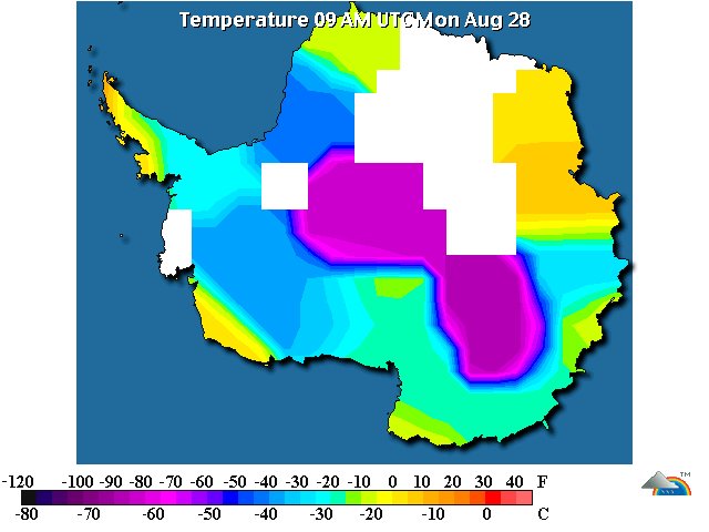
August 28, 2006.
9:00 AM.
Antarctica
There is a 'heat incursion' noted at 6:00 AM. There aren't above zero temperatures registered yet, with the warmest of (-3C) at Palmer Station.
The temperatures across Antarctica (click on)
The temperature at Palmer Station
26 °F / -3 °C
Light Snow
Humidity:
76%
Dew Point:
21 °F / -6 °C
Wind:
9 mph / 14 km/h from the ENE
Wind Gust:
-
Pressure:
29.24 in / 990 hPa (Rising)
Visibility:
3.0 miles / 4.8 kilometers
The higher temperatures won't show up in monitoring stations reported here until they sustain.
Thus far, Antarctica has enjoyed a wonderful retreat of heat for it's ice.
The ice terraces and shelves that have been lost to Human Induced Global Warming takes more than one good season of frigid temperatures to rebuild. It is however 'buying time' on this timeline to biotic demise.
The ice at Antartica is not temperate (Freezing at zero degrees Celcius as do the Juneau Icefields). It is deeply frozen under decades and centuries of hydrostatic pressure. The ice found at the very depths of Lake Vostok is different than the ice found floating in the Ross or Weddel Seas. It has been long known the ice of the seas of Antarctica (WAIS - West Antarctica Ice Sheet - click on), the Greenland Ice and the Arctic Ocean of the northern polar regions are the ice masses that control the climate temperatures of Earth. While the tall 3 mile Blue Ice is valuable to Earth and is a resource to cooling it does not have the immediate impact as the ice resources that touch the oceans. The tall Blue Ice is a fascination all to itself and can be noted in it's 'rock/waterflow' characteristic in the Lambert Ice Flow (click on).
The cross section below may give a better 'idea' of the differences of 'types' of ice of Antarctica.

Morning Papers - concluded
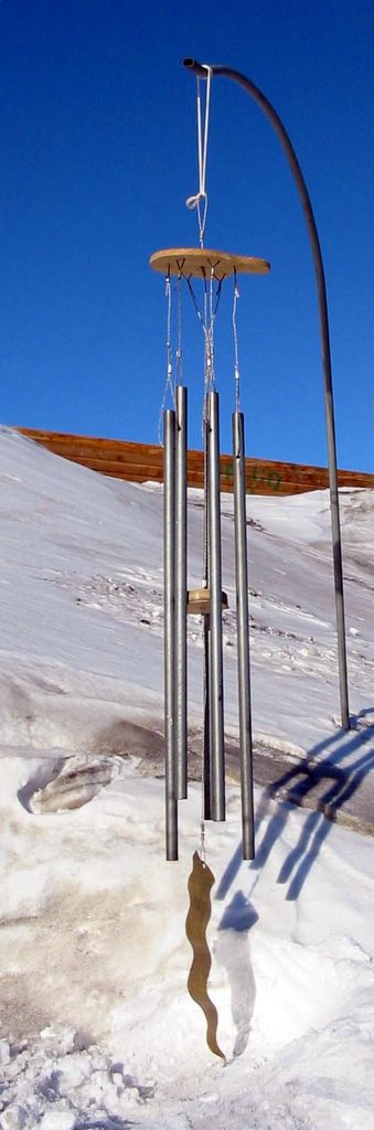
The weather in Antarctica is (Crystal Ice Chime) is:
Scott Base
Snow
-24.0°
Updated Monday 28 Aug 8:15PM
The weather at Glacier Bay National Park (Crystal Wind Chime) is:
50 °F / 10 °C
Mostly Cloudy
Humidity:
82%
Dew Point:
45 °F / 7 °C
Wind:
4 mph / 6 km/h from the NNW
Pressure:
29.86 in / 1011 hPa
Windchill:
49 °F / 10 °C
Visibility:
10.0 miles / 16.1 kilometers
UV:
0 out of 16
Clouds:
Few 2300 ft / 701 m
Scattered Clouds 3200 ft / 975 m
Mostly Cloudy 3800 ft / 1158 m
(Above Ground Level)
end
Click on for loop
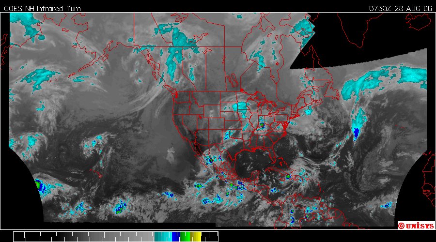
August 28, 2006.
0730z.
Enhanced Infrared Satellite by UNISYS. This is the northwestern hemisphere.
It is not easily discernable on this satellite but there is a very large vortex with a center over southern Alabama. It is having an impact on the weather in the entire region. As this system takes better defination it may be more evident in these satellites. If one cares to the 'Water Vapor' satellite is far more helpful, but, is also more confusing to the average person. I resist using the higher resolution satellite because it can be alienating and actually 'kinda' scary. The infrared will shape up IF the components of higher velocity storms take shape.
Click on for loop

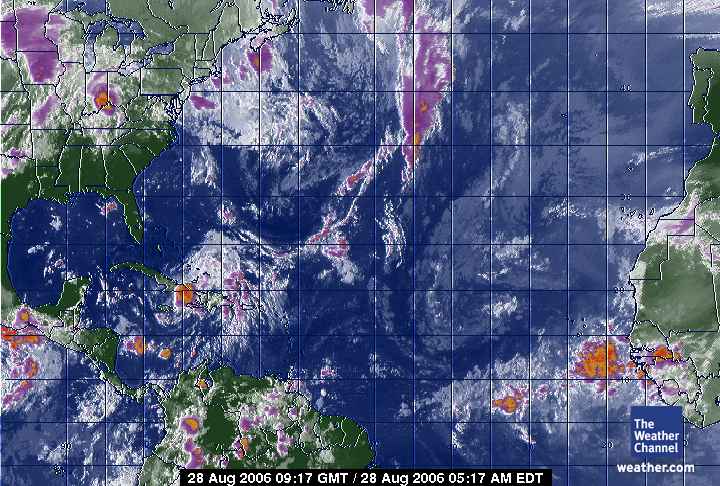
August 28, 2006 gmt.
0915z.
GOES East Enhanced Infrared.
In the loop, to the link at UNISYS, it is noted that Ernesto, also known as FIVE, 'oscillates' a great deal. The oscillation is so large that at some points Storm FIVE seems to dissipate completely. That is typical of the Human Induced Global Warming Storm. They have 'energy' and that energy never completely leaves the system so much as 'interacts' with the surface of Earth, dissipating energy and absorbing it as well in a chronic interchange of heat distribution.
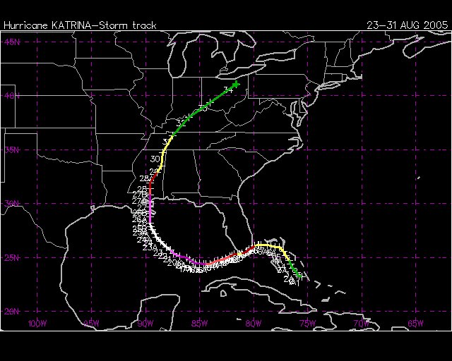
Katrina's path.
Crossed south florida at Cat 1.
Katrina was the end of a tropospheric vortex as noted in pictures below. I imagine Ray Nagen has this path emblazened in memory by now. Of course, his response then was more correct than any other, "The federal government never replenished the wetlands."
This is not a prediction.
A question of fuel. If there is sufficient humidity. If there is sufficient heat. Then we have another Katrina.
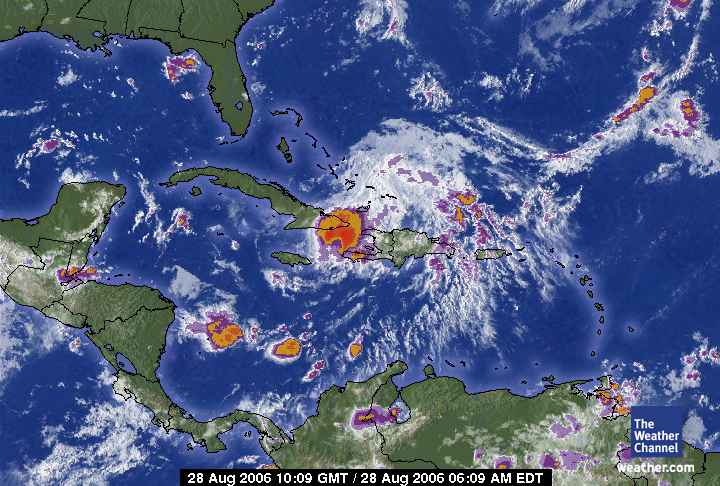
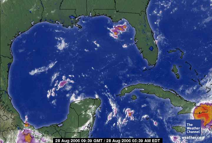
August 28, 2006.
1009 gmt.
Caribbean Sea Satellite.
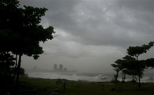
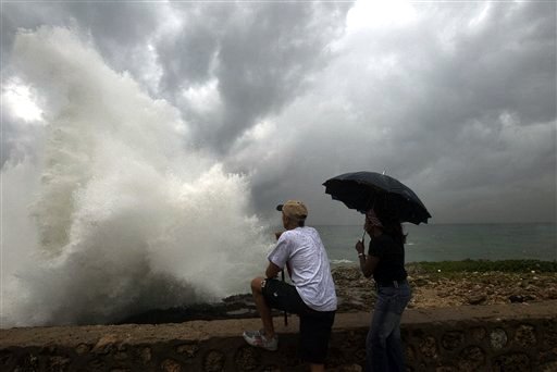
Ernesto lashes Haiti's southern coast By STEVENSON JACOBS
LES CAYES, Haiti — Ernesto became the first hurricane of the Atlantic season Sunday then weakened to a tropical storm as it lashed Haiti's southern coast with heavy rain and flooded homes in the impoverished country.
But the storm was projected to regain strength as it steamed toward Cuba and the Gulf of Mexico and forecasters said it could again reach hurricane force before striking Cuba on Monday morning.
Cuba ramped up emergency preparations and forecasters said the storm would be close to the island's southeastern coast Monday morning, with a brief return to hurricane force possible.
"We do expect it to reach the Gulf, maybe as a Category 1 hurricane, possibly a Category 2," said John Cangialosi, a meteorologist with U.S. National Hurricane Center in Miami. "We expect it to be a significant system as it moves over Florida."
It was uncertain where Ernesto would make landfall as it moves toward the Gulf coast, but the storm does not appear to pose a threat to New Orleans, forecasters said. Category 3 Hurricane Katrina struck the city a year ago Tuesday and devastated it.
"It's difficult to say where it will be, but in three days we're projecting it anywhere from the eastern Gulf near the Florida panhandle to the western Bahamas," said Cangialosi.
By late Sunday night, Ernesto's winds slowed to near 50 mph, down from 75 mph earlier in the day when it became the first hurricane of the Atlantic season, according to the hurricane center.
Florida Gov. Jeb Bush declared an emergency, ordering tourists to evacuate the Florida Keys.
"It's on a track toward the Florida peninsula early this week, and all of Florida is in the area that's being threatened, from the Keys all the way up to the panhandle," said Michael Brennan, a meteorologist at the center in Miami.
Ernesto was moving northwest at 7 mph on Sunday night. It passed near the tip of Haiti's southwestern peninsula in the afternoon. Forecasters said as much as 20 inches of rain could fall in some mountain areas, raising fears of flash floods in the heavily deforested country.
Marie Alta Jean-Baptiste, director of Haiti's civil protection agency, said by telephone that one person on Vache island off Haiti's south coast died in the storm. She said she could not give any details.
Skies darkened as wind gusts swayed palm trees in Les Cayes, a town 95 miles west of the capital, Port-au-Prince. People put their goats and cows into shelters, and fishermen pulled nets ashore.
"The only thing we can do is just wait and keep our fingers crossed," said Frantz Gregoire, 42, owner of the seaside Bay Club, a thatch-roofed wooden restaurant. He said he would close early and send his workers home if the storm worsened.
Officials went on the radio to warn people living in flimsy shantytowns on the coast to seek shelter in schools and churches.
"These people could be in great danger," said Adel Nazaire, a coordinator with Haiti's civil protection agency. "Flooding is the biggest concern because a lot of residents live along the rivers and the sea."
Haitian authorities also evacuated some people from low-lying areas in the northwestern city of Gonaives, which was devastated by a flood during Tropical Storm Jeanne in 2004. There were no plans for further evacuations, but "if there's more rain later we may have to," Nazaire said.
In Cuba, the government issued a hurricane warning for six eastern provinces.
The Communist Youth newspaper Juventud Rebelde warned of heavy rain, winds and potential flooding on the southeast coast starting Sunday night. Cattle were moved to higher ground, and workers cleaned gutters and picked rubble off the streets ahead of the storm.
Tourists were evacuated from hotels in the southeastern province of Granma and baseball games scheduled for Sunday night in Havana were played earlier in the day.
Heavy rain and winds were expected in southern Florida by early Tuesday.
In Key West, officials told visitors to the island chain to head for the mainland and ordered all travel trailers and recreational vehicles to leave immediately. The low-lying Keys are connected to each other and the mainland by just one highway, U.S. 1.
The Royal Caribbean cruise line said it was diverting three ships scheduled to depart the United States on Sunday and Monday, sending them to alternative Caribbean ports to avoid the storm. Carnival Corp. said it was changing the itinerary of five ships in the region.
At 11 p.m. EDT, Ernesto, the fifth named storm of the Atlantic hurricane season, was centered near the western tip of Haiti about 115 miles south-southeast of Guantanamo, Cuba.
Subscribe to:
Posts (Atom)