May 26, 2016
6:35 PM
Wind map (click here)
May 26, 2016
By Tribune staff
Power was full (click here) restored by mid-morning to more than 1,100 electric customers who lost service as strong storms rolled over the county overnight..
A severe thunderstorm warning was issued around 3:30 a.m. with wind gusts topping 60 mph in some areas.
There was a report of a tree toppled along Story County S-14 near Nevada, and tree limbs down near Zearing. Otherwise, no damage had been reported, according to Story County officials and officials with the National Weather Service in Des Moines.
 Only a few customers in Ames had lost power, but more than 1,100 in surrounding areas and communities lost power as the storms moved through.
More storms are possible later today and tonight.
Current Temperature Map US (click here)
May 26, 2016
6:00 PM
In the water vapor satellite below it is easy to tell where the heat is; under the densest area of greenhouse gases. The water vapor is not consolidating anywhere else in the northwest hemisphere of Earth. There is some in the ICTZ where it belongs.
May 26, 2016
2230.19z
UNISYS Water Vapor Satellite of north and west hemisphere (click here for 12 hour loop - thank you)
The water vapor is not consolidating in the west where the troposphere is cooler.
 The wind chill map also shows even greater differences in temperatures in the west USA.
The west has wind chill temperatures in the 50s while the midwest and east are in the 90s. That is 40 degrees Fahrenheit difference. That is dangerous.
This is probably the beginnings of the current system.
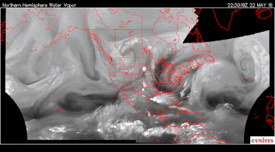
May 22, 2016
2230.14z
UNISYS Water Vapor Satellite of north and west hemisphere.
There was talk at this point about a developing hurricane. That didn't happen. The tornadoes are the result of a dry troposphere. If the water vapor content was NORMAL there would have been a hurricane rather than tornadoes.
In today's satellite (third from the top) there is a hint of a potential hurricane in the Atlantic, but, far off shore. There is a persistent consolidation of water vapor in the Atlantic at this location regardless of the wind otherwise. There is a better than 50% chance that as tornadoes and severe storms erupt over night, that water vapor consolidation will be gone by tomorrow. If the storms and tornadoes are weak tonight, there is a better chance the water vapor consolidation will be greater and increase the chance of a hurricane in the Atlantic. With 40 degree Fahrenheit difference, there should be significant turbulence where the water vapor has gathered over the USA.
Hurricanes and tornadoes dissipate heat.
6:35 PM
Wind map (click here)
May 26, 2016
By Tribune staff
Power was full (click here) restored by mid-morning to more than 1,100 electric customers who lost service as strong storms rolled over the county overnight..
A severe thunderstorm warning was issued around 3:30 a.m. with wind gusts topping 60 mph in some areas.
There was a report of a tree toppled along Story County S-14 near Nevada, and tree limbs down near Zearing. Otherwise, no damage had been reported, according to Story County officials and officials with the National Weather Service in Des Moines.
 Only a few customers in Ames had lost power, but more than 1,100 in surrounding areas and communities lost power as the storms moved through.
More storms are possible later today and tonight.
Current Temperature Map US (click here)
May 26, 2016
6:00 PM
In the water vapor satellite below it is easy to tell where the heat is; under the densest area of greenhouse gases. The water vapor is not consolidating anywhere else in the northwest hemisphere of Earth. There is some in the ICTZ where it belongs.
May 26, 2016
2230.19z
UNISYS Water Vapor Satellite of north and west hemisphere (click here for 12 hour loop - thank you)
The water vapor is not consolidating in the west where the troposphere is cooler.
 The wind chill map also shows even greater differences in temperatures in the west USA.
The west has wind chill temperatures in the 50s while the midwest and east are in the 90s. That is 40 degrees Fahrenheit difference. That is dangerous.
This is probably the beginnings of the current system.
May 22, 2016
2230.14z
UNISYS Water Vapor Satellite of north and west hemisphere.
There was talk at this point about a developing hurricane. That didn't happen. The tornadoes are the result of a dry troposphere. If the water vapor content was NORMAL there would have been a hurricane rather than tornadoes.
In today's satellite (third from the top) there is a hint of a potential hurricane in the Atlantic, but, far off shore. There is a persistent consolidation of water vapor in the Atlantic at this location regardless of the wind otherwise. There is a better than 50% chance that as tornadoes and severe storms erupt over night, that water vapor consolidation will be gone by tomorrow. If the storms and tornadoes are weak tonight, there is a better chance the water vapor consolidation will be greater and increase the chance of a hurricane in the Atlantic. With 40 degree Fahrenheit difference, there should be significant turbulence where the water vapor has gathered over the USA.
Hurricanes and tornadoes dissipate heat.


