June 9, 2010
00:17 GMT
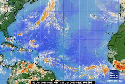
Atlantic Ocean Satellite
The FIRST hurricanes of the season are gaining potential as well.
Red River Valley is in the path of the potential tornadoes and heavy rain.
The same vortex street is taking a north - east track. The Jet Stream is becoming dominated by the vortexes again. The 'heat plume' coming up from the equator is going to reek havoc with the air mass and movement in the central USA.
There are actually two streets, the ones nearest the equator is primarily stationary. Those are starting to pick up some minor amount of moisture. Minor in the sense of 'percent of water vapor to size of vortex.' With added water vapor there might be some added turbulence and movement in the equatorial systems.
Severe thunderstorms, hail move across St. Louis region
By Lisa Watson
Tuesday, June 8, 2010Tuesday afternoon thunderstorms brought hail to the St. Louis region and are expected to continue through the night.
A flood warning is in effect in St. Charles County, and a severe weather warning has been issued for St. Louis City, St. Louis County, and St. Clair County and Monroe County in Illinois. A storm capable of producing quarter-sized hail was spotted in the region, according to the National Weather Service.
Very large hail is possible, as are strong winds and isolated tornados, according to the National Weather Service. Severe weather moved in from the northwest Tuesday morning, and was expected to bring 1 to 2 inches of rain across Northeast Missouri, West Central and Southwest Illinois.
Globe-Democrat.com spotted dime-sized hail in St. Louis County.
Unstable conditions in the atmosphere and a slow-moving front will keep rain in the forecast through Sunday, according to the Weather Service
http://www.globe-democrat.com/news/2010/jun/08/severe-thunderstorms-hail-move-across-st-louis-reg/

