August 24, 2006.
Wolsey, South Dakota.
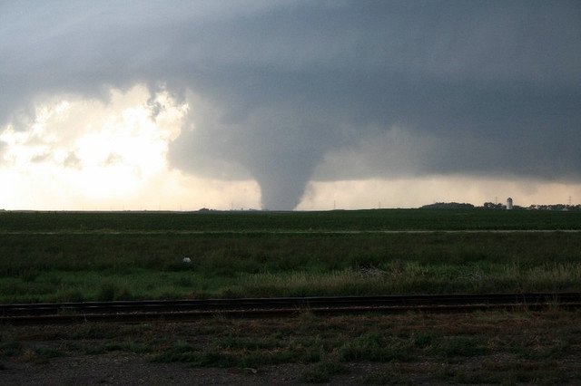
This tornado is more than just trouble, it reveals to me a trend in the greater density of the vorticities now in the troposphere. This is the first time I have noted a tornado ATTACHED to a greater voticity.
Caught on home video, "It's a monster"
http://www.kare11.com/news/news_article.aspx?storyid=133168
This video report is completely indicative of what I have been noting as a NEW PHENOMENA in this Human Induced Global Warming troposphere. These storms are sudden and have incredible impact including huge deluges of rain that DO NOT contribute to releaving drought, but, serve as overland flow that causes flooding.
Kindly pay attention to his observation skills and his ability to rely it to others. This 'nerves of steel' allow him to deliver a very valuable message.
http://www.kare11.com/video/player.aspx?aid=32477&bw=
This video clip shows the benign way in which a tornado APPEARS to start. Tornadoes aren't actually seen UNTIL they start to kick up debris that combines with the cloud humidity. As a matter of fact this video is quite extensive in noting the clouds on the horizon beyond the tornado and the velocity they are moving. This tornado was also a quickly developing vorticity in that by the time the end of the tape is noted, the vorticity actually is spinning so fast it 'deposits' pieces of itself on the ground. The 'drag' by the ground/Earth/land doesn't slow down the vorticity at all, it simply breaks off and continues. This is possible because the vorticity is actually a ground manifestation of a much higher velocity that extends well into the troposphere. The tornado is supported from a higher density than just what is evident within a doppler tracing as well. It's an excellant video. I tells a story I could only hope to see.
http://www.kare11.com/video/player.aspx?aid=32479&bw=
The video shows what I dread. It is a vorticity without a focal point. It literally is the heat coming out of the sky and 'landing' inadvertently anywhere it finds it's dynamics satiated. As a matter of fact this type of vorticity doesn't have satiation. Noted at the trailing edge of this vorticity is a higher density of debrise mixed with cloud mass. THAT if the vorticity of the heat of the upper levels were less would be a focal tornado. But do to the support from the upper troposphere the focal point is swallowed up with satiation. It is a dangerous storm. My concern is that this high velocity will be an increasing trend ESPECIALLY if there is an abatement of 'heat transfer' into the oceans by hurricanes.
http://www.kare11.com/video/player.aspx?aid=32480&bw=
I really don't see these manifestations any different from that of hurricanes IN THAT there is constant heat energy that needs relief under carbon dioxide density of the troposphere. That energy ONLY diminishes for Earth as the carbon dioxide layer lessens. With a less dense carbon dioxide layer, the infrared heat retained by Earth is less and diminishes these storms. My concern is that these storms are the trend and not just a peculiarity from time to time.
These are very high velocity storms. They literally overrun their own ability to maintain contact with the ground. Really good video. This man is absolutely correct in being 'flat out scared' it is an instinct to be trust and respected. Just don't run toward the storm, okay?
http://www.kare11.com/video/player.aspx?aid=32559&sid=133212&bw=
Severe storms here aren't over yet
Flood advisory issue for three area counties
By Bill Novak
Severe thunderstorms slashed across south central Wisconsin Wednesday night, the first wave of bad weather expected to continue to hammer the area today and Friday.
"The next 36 hours will be fun," said Weather Central meteorologist Bill Romine this morning, after a long night of spectacular thunder and lightning, torrential downpours, big hailstones and one unconfirmed tornado in Sauk County.
The National Weather Service issued a flood advisory today for Dane, Columbia and Rock counties in south central Wisconsin, as storm runoff had the potential to cause flooding of small streams and creeks, highway underpasses and other low-lying areas.
While the storms were loud and bright Wednesday night, very little damage was reported to authorities in the Madison area. But American Family Insurance spokesman Steve Witmer said hail damage claims are starting to come in.
"We've had a couple hundred property claims so far today," Witmer said, "with 100 automobile claims from the Tomah area alone."
http://www.madison.com/tct/news/index.php?ntid=96176&ntpid=1
Tornadoes tear through southern counties
Storms damage buildings, cause mostly minor injuries but no deaths
BY TAD VEZNER
At least three tornadoes whipped through rural areas of southern Minnesota on Thursday, resulting in dozens of injuries as well as damaging buildings and downing power lines.
The National Weather Service confirmed the first two tornadoes touching down about 5:45 p.m. several miles west of St. Peter, near the town of Nicollet, in Nicollet County. The tornadoes traveled east, passing just south of St. Peter, and minutes later were reported to the southeast of St. Peter, in Le Sueur County.
Rain wrapped the funnels, making them difficult to see before they struck, the NWS reported.
A third tornado touched down at 7:14 p.m. near Mantorville, threatening Dodge and Olmsted counties.
Other tornadoes were seen in Kasota, Kilkenny and Waterville, the NWS reported.
http://www.twincities.com/mld/pioneerpress/news/local/15354971.htm
Tornadoes Hit Northern Ind., Minn., Causing Damage and One Death
August 25, 2006
Severe thunderstorms and tornadoes swept off Lake Michigan Wednesday evening, downing trees and power lines and causing some injuries in Indiana and killing one resident in Minnesota.
In LaPorte County, Ind., 911 Assistant Director Beth West said some injuries were reported in the county, but she did not have any details.
Heavy damage was also reported at a boat show scheduled to begin Thursday at the Washington Park Marina on Lake Michigan, police said. The News-Dispatch reported vendors setting up for the show were hit hard and some docks were moved, but most of the yachts and boats were safely harbored in nearby Trail Creek.
Instruments with the U.S. Coast Guard measured winds of up to 92 mph.
http://www.insurancejournal.com/news/midwest/2006/08/25/71715.htm