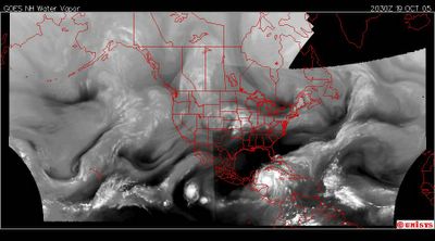
October 19, 2005. 2030 z.
Let's get started.
FIRST:: The storm surges will be gigantic and SUSTAINED. Get everyone away from the coasts of all the current areas in the Caribbean.
The water vapor satelllite shows the subtilties that are necessary to understand the dynamics of this storm.
NOTED :: There are minimally three heat concentrations of 'size.' The first in the Pacific. I don't know if The National Hurricane Center is still considering it a Tropical Depression 16E. It is minimally that in my opinion. Then there is 'eddy 1' called "Wilma" and of course that is the focus for those that are in government. We'll maintain that focus regardless of the meandering otherwise. The third heat concentration is the cluster of water vapor east of the Lesser Antilles.
The oscillation that I observed in the 'eye' of Wilma is due to the chronic movement of energy (heat energy) along the 'eddy' curve all the way to the Tropical Depression 16E. In other words I don't believe 'Wilma' is wavering. I think it is simply in response to moving ionized energy that is contributing to the increased size and velocity of the Pacific tropical depression 16E.
To move to the third component of this system, east of the Lesser Antilles, there is a developing vortex 'shunting' to that system putting less pull on a northeastern direction of 'Wilma.' Do you see it? It isn't easy to note but it is there and has been. Like I stated there are subtile issues here to make accuracy as good as it gets. This 'shunting' of vorticity to 'eddy 2' allows more dynamics to be shared with 'TD 16E' and 'Wilma.'
Now, the fourth 'symptom' of this systme is the 'vortex street' which is in oscillation over North America. It is running from the equator to the North Atlantic/Arctic Circle vortex. It is maintaining a CONSISTENT distance from coastal Gulf of Mexico. Why? What is impinging on that vortex street to PUSH it north? If noted the vortex flow of water vapor just north of TD16E disappears when it reaches the threshold of North American land masse where the consistent absence of water vapor continues. THAT same vortex moisture stream is again realized on the Atlantic side of the continent.
With the growing dynamics of TD16E and the 'shunting' of vortex pull to 'eddy 2' the dirction of 'Wilma' is into the Gulf and in my opinion given the fact I don't have fancy computer models IF THE IONIC PULL OF THE VORTEX CONTINUES TO WEAKEN onto Galveston, Texas.
I am probably dead wrong. I just don't think so at this point.