At the very least, there will be lava picked up and carried, either as fire or a very hot ember. The winds of Hurricane Lane need to be scrutinized for any potential direction of debris carried into populated areas. Hurricanes also spawn tornadoes. So, the level of wind direction MUST be paramount to any monitoring of Hurricane Lane.

Kindly recall, Hurricane Irma (click here) caused seismic activity along it's path that was recorded by underwater equipment. This potential carries new risks to the people in the path of these storms. If Lane is strong enough to cause enough underwater turbulence, the outcomes to the current vent and also closed vents has the potential to become a greater threat and more active. Lane may close the darn thing as well, but, I doubt that sincerely. If anything, Lane will encourage a wider vent opening or knock existing cooled lava to crack or chip to reopen the other vents.
The St. Maarten occurrence is worrisome with Irma. The greatest record of turbulence was not the external winds, but, the eye. That is completely contrary to what I would expect given the fact the eye of a hurricane is calm and absent of turbulence, especially a well formed eye as with Irma.
 August 19, 2018
By Hawaiian Volcano Observatory
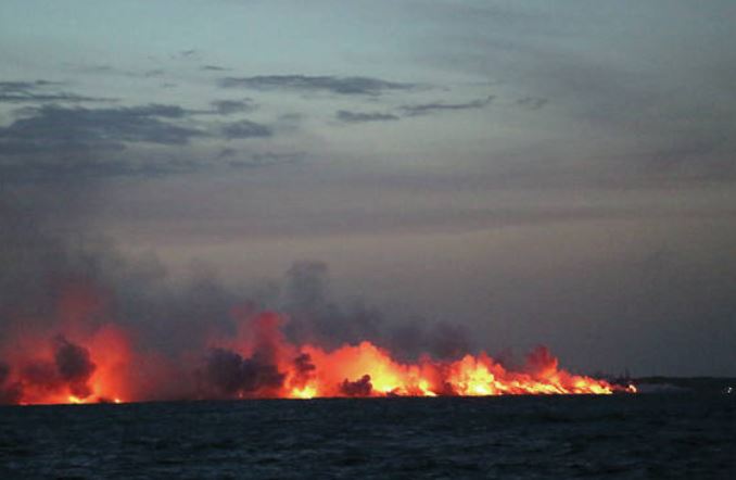
Nighttime scene from shipboard of lava entering the Pacific Ocean on July 12, captured from a scientific research vessel deploying submarine seismometers.
The visible part of Kilauea from the summit (click here) to the Lower East Rift Zone makes up only a small portion of the total volcano. Much of Kilauea lies beneath the sea, including the Puna ridge to the east and the south flank extending offshore beyond the southern coastline.
As the volcano grows, this underwater region of the south flank creeps slowly to the south, moving in fits and starts with earthquakes that last seconds (such the May 4 magnitude-6.9 event) and in slow slip events, which last for days or weeks. Many questions have been raised about the stability of the south flank, since other portions of Hawaii Island’s coasts show evidence of past landslides....
Kindly note, there was a marked difference between Harvey, Irma and Maria. Maria was a storm of extreme infrastructure devastation. (click here) BUT, it was Irma's footprint that caused seismic disturbance. If the maximum seismic disturbance is realized when the eye of Irma passed over head, that means the LACK of pressure/extreme low pressure will ALLOW OPPORTUNITY for movement.
I think it foolhardy to ignore the potential for danger to Americans. The winds and the eye have to be realized to have a greater danger than normally estimated with Hurricane Lane.
If the eye doesn't make landfall, which is still possible, the bands surrounding the eye will. I would not under estimate Lane. It is gathering water vapor in it's traverse across the Pacific and currently Hawaii is awash in water vapor that can become incorporated into Lane's velocity. The higher the water vapor content the greater chance there will be an acceleration in winds.
UNISYS Water Vapor GOES West satellite image (click here for 12 hour loop - thank you)
August 20, 2018
1200:18z
