December 24, 2012
11:30:01z
UNISYS Water Vapor Satellite of North and West Hemisphere (click here for 12 hour loop - thank you)
There is also three vortexes.
The Weather Channel
Current Weather Map
December 24, 2012
12:04 gmt
The troughs between the vortexes are high pressure, otherwise, the USA has low pressure systems dominating the weather.
But, to note, regardless of the cloud cover there is little to no precipitation.
The Southeast is receiving rain. It is directly under a vortex.
The Weather Channel
National Doppler Radar
December 24, 2012
12:22 gmt
It is easier to see the weather on this map. The NORMAL standard for weather without precipitation is a high pressure system. That is not occurring here.
High Pressure Systems are not dominated by dense clouds cover.
The cloud cover in the UNISYS Water Vapor satellite above is where the water vapor is located in the upper troposphere. The precipitation is not reaching the ground.
Wet weather could turn severe by Tuesday night (click here)
By Mike Morris
The Atlanta Journal Constitution
“A strong storm system will be developing over the lower Mississippi Valley Tuesday, bringing widespread rain and isolated to scattered thunderstorms to much of north and central Georgia Christmas Day through Wednesday morning,” the National Weather Service said in a statement early Monday....
...“At this time, the main concerns will be isolated tornadoes as well as strong damaging winds in excess of 60 mph....
The Weather Channel Current Temperatures December 24, 2012 12:15 gmt
In the northern areas of the USA where snow has fallen in the past weeks, it was followed up by high temperatures. I have personally noted the subliming of the snow when the higher temperatures moved in over the snow. These are not high temperatures. The highest temperature at the time was 64 degrees Fahrenheit. The change was rapid, cold one day with snow and then warming up suddenly and the snow was gone, with no water runoff and dry roads.
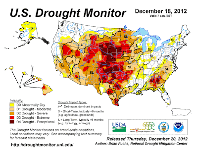
The drought of the country is continuing.
U.S. Drought Monitor
December 18, 2012
Valid 7 a.m. EST
Snow melts in the Spring of 2013 will not necessary refill reservoirs as this is the second year I have noted the sublimation of snowfall rather than water runoff.
The 'quality' of the snowfall is light and fluffy. High volume accumulation which contains significant amounts of air. The rapid change of air temperature literally penetrates the snow and vaporizes it. The snowfall is high volume and not very wet or dense. It doesn't stay around long enough to compact forming ice either. When vehicles run over it, it turns to ice. Even that ice is exposed to higher temperatures quickly and disappears simply because there is no residual coldness to support the ice. Basically, the snow disappears first, the ice is the only residual coldness and not supported by snow and the ice disappears quickly afterwards.
This outcome also reduces the white reflective quality of sustained snowfall to cool the troposphere. This is fact and can be validated by local weather reporting stations that provide traffic conditions and road conditions around the country.
The sublimination of the snow is noted in fog. Depending on the volume of snowfall it can be reported in the media as dense fog with low visibility.


