
Overview of Conditions
Arctic sea ice extent in December 2011 averaged 12.38 million square kilometers (4.78 million square miles). This is the third lowest December ice extent in the 1979 to 2011 satellite data record, 970,000 square kilometers (375,000 square miles) below the 1979 to 2000 average extent.
Arctic sea ice extent in December 2011 averaged 12.38 million square kilometers (4.78 million square miles). This is the third lowest December ice extent in the 1979 to 2011 satellite data record, 970,000 square kilometers (375,000 square miles) below the 1979 to 2000 average extent.
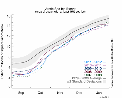 Ice extent was particularly low on the Atlantic side of the Arctic, most notably in the Barents and Kara seas. The eastern coast of Hudson Bay did not freeze entirely until late in the month: normally, Hudson Bay has completely frozen over by the beginning of December. In the Bering Sea, ice extent was slightly above average....
...The graph to the right shows daily Arctic sea ice extent as of January 3, 2011, along with the ice extents for the previous four years. 2011 is shown in light blue, 2010 is in pink, 2009 in dark blue, 2008 is in purple, and 2007, the year with the record low minimum, is dashed green. The gray area around the average line shows the two standard deviation range of the data. ...