The weather patterns (click here for loop) in southern hemisphere has to be continually evaluated during this summer season.
There is a huge amount of equatorial water vapor being delivered into the summer time heat. That spells trouble.
The people of Australia, especially northeast Australia, has had a very difficult spring and summer thus far. There was a point when there were dual typhoons in Australia's northeast.
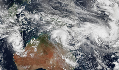
This was March 2015 for Australia's new reality. Three typhoons at one time.
In February 2015, (click here) a pair of cyclones hit Australia within six hours of each other. A few weeks later, yet another batch of storms—three this time—churned remarkably close to Australian coasts.
The Moderate Resolution Imaging Spectroradiometer (MODIS) on NASA’s Terra satellite, captured this view of Cyclone Pam (top) on March 11, 2015, at 22:50 UTC as it neared the island chain of Vanuatu. In a mosaic (bottom image) also captured on March 11, Pam and two other storms—Nathan and Olwyn—were lined up in a row north of the continent. The mosaic is based on data collected during three orbital passes of the Visible Infrared Imaging Radiometer Suite (VIIRS) on Suomi NPP. (The MODIS on Terra acquired similar imagery later that day.)
Forecasters expect that Pam, the strongest of the three storms, will have a major effect on Vanuatu. With sustained winds of 155 miles (250 kilometers) per hour and gusts up to 190 miles (300 kilometers), Pam was already the equivalent of a Category 5 storm on March 12. As Pam moves toward Vanuata, the storm will push through an area with relatively weak upper level winds and unusually warm water, so it should continue to strengthen. According to the Joint Typhoon Warning Center, Pam’s peak intensity will likely coincide with its closest pass to the island Efate, which is home to Vanuatu’s capital city, Port Vila....

