The Chicago Storms
Tom Skilling, WGN-TV chief meteorologist
Published September 23, 2006
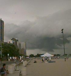
With a 140 mph jet stream directly overhead, a strong influx of warm, moist air from the Gulf of Mexico, and a warm front just to the west and south of Chicago, all the ingredients were set for a severe storm outbreak late Friday afternoon. Heavy downpours hit in eastern Kane, northern DuPage, and northern Cook counties. St. Charles and Mount Prospect reported over 3 inches of rain in an hour and a half. Those areas and many others reported flooded streets and paralyzed traffic. O'Hare's 1.73 inch total far exceeded the previous record (1.09 inches in 1965) for Sept. 22. Aided by instability created by the diverging jet stream flow aloft and the converging winds at the warm frontal boundary below, towering storms built to 58,000 feet tall. Downdrafts resulted in widespread hail and wind damage (70 mph reported at Hanover Park and 60 mph near West Chicago). Funnel cloud reports and Doppler radar signatures prompted at least seven tornado warnings.
................................................................
JUST AS A SIDE NOTE to the entries below regarding 'injection wells.' They are a National Security Risk. From the stand point of earthquakes and any concept that a large impact bomb could cause some serious release of 'who knows what.' That is why it is important to find a way to 'seal' the subsurface wells with other methods such as dilution of other chemicals that interact with the contaminant to neutralize it and/or create a viscous solution that is impossible to disrupt no matter what.
