
1230.18z
UNISYS North and West Hemispheric Water Vapor Satellite (click here for 12 hour loop - thank you)
This blasted thing is carrying water vapor to the southeast USA. It looks like a sister vortex is forming. I think it will form another street up to Arctic Circle.
 It has plenty of water vapor. By the fact this is moving hot water to the Arctic Circle, it is a heat transfer system. The oscillation trail east is definitely heat transfer. That is sort of standard of the heat transfer systems that don't produce rain. But, I've never seen it like that.
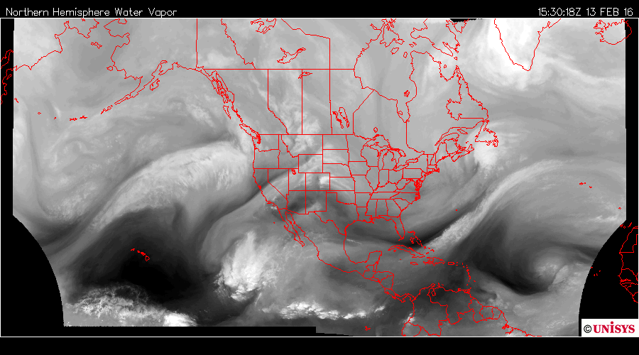
1530.18z
UNISYS North and East Water Vapor Satlitte
I've been watching this air mass for days. It has been robbing the ITCZ for days. It looks like a giant pinwheel, but, there is that oscillation trail heading east.
 February 10, 2016
1115.18z
UNISYS North and East Hemisphere Water Vapor Satellite
I tell you what. With all this water vapor moving into the USA, including the west coast, the airline industry needs to be exceptionally vigilant of any air turbulence.

0900 utz
Map by NOAA (click here)
NOAA is going to have to be on their toes today. The water vapor is fairly dense aloft. The changes happen fast with these moving air masses.
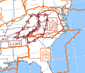
Yep. It is already raising concern. That is where the water vapor is creating a vortex.
Some time ago I wanted to have pilots fill out a questionnaire about turbulence and their experience compared to previous years. In other words, are the winds at all attitudes getting more turbulent compared to previous years? Is each year getting more or less dicey? The project never came together. I should have asked their union about it.
The USA should be very interested in what their pilots are saying, including military pilots. You know the USA thinks air superiority is sophisticated. Not if the climate doesn't let them fly.