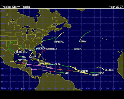
2007 saw seventeen named storms of which two were Cat 5, three Cat 1 and the rest were all Tropical Storm force.
The 'lay of the land' became very, very different. The storms were now forming where 'water vapor' was available along with enough heat to EVAPORATE the water to accumulate that water vapor, namely 'near shore' and on the Equator.
The two Cat 5 storms would occur where there was the most dense accumulation of water vapor and that was along the equator. The storms could no longer be sustained in their vorticity in the upper reaches of the Atlantic above the latitude of 15 degrees north. There simply wasn't enough water vapor and the 'near shore' storms took on many different formations including one storm which was literally 'upside down' in its traverse along the Eastern Seaboard of North America.
The 'reach' eastward into the Atlantic toward Europe of the storms nearly ended and with that the heat distribution of the Cat 5 storms was directed to latitudes of about 15 degrees north. Which means the waters of the 'Equatorial Earth' would sustain the highest deposit of heat. Realizing that, one has to remember the future of the predicted storms is that WHEN a hurricane will occur it will be with higher volatility. To realize the 'heat concentration' is now at 15 degrees north or less moving toward the Equator is to realize the degree at which these storms will increase in number while sustaining Cat 5 status chronically.