Wednesday, May 28, 2008

Fahrenheit 911 - Michael Moore how right could you be ? "...there was incideous pressure...they weren't aggressive enough..." Katie. (click here)


When does Michael Moore (click here) get an apology from a hostile Republican Party and half a nation of non-believers?

Unlike the American Media, Mike is a "Truth Teller." He is more than a provacateur! He is a patriotic and dedicated American citizen.


It's all about money when it comes to Republicans (click here). Book profits should be directed to the families of dead soldiers and soldiers suffering sustained combat wounds from Iraq !!!

Why didn't McClellan come clean while he was in the White House? I think he needs to be indicted on conspiracy against the American people along with Bush and Cheney ! This is worse than fraud. This is abuse of power. At least Nixon's impeachment was due to his own paranoia regarding his re-election. This is blantant abuse of power. Soldiers are dead. A nation in profound debt with a destroyed international reputation.


HELLO ? The media is guilty as hell here and they all know it !


Michael Moore could not be more correct or more patriotic. Who really loves the country? Those that seek its power to facilitate wealth at any cost or those that stand by the USA Constitution when its under attack?


Katie really nails the issue including the attacks on Americans that they were unpatriotic if they opposed the war. Charlie avoids the issue at all costs and the conversation ends with 'happy talk' about raising money for cancer research. Gee, what happened to News Anchors with angry voices that state, "So how does Bush and Cheney now justify nearly 5000 dead American soldiers, countless others including Iraqi citizens, the continued occupation of that country, an insurmountable federal debt, the backlash that has on states and cities and the outing of a CIA agent? Are they asking those questions yet ? I didn't think so.

Amnesty Calls for Implementation of UN Rights Charter

(VOA article - click here) MP3 click on title to entry.

Amnesty International says many governments have failed to implement the Universal Declaration of Human Rights 60 years after it was adopted, and owe the people an apology. In its annual human rights report, the organization looked at the record of 150 countries and found many of them wanting. (click here)
From the London VOA News Center, Tendai Maphosa has this report.

2008 Amnesty International Report (click here)

The Universal Declaration of Human Rights (click here)


"Where, after all, do universal human rights begin? In small places, close to home - so close and so small that they cannot be seen on any maps of the world. Yet they are the world of the individual person; the neighborhood he lives in; the school or college he attends; the factory, farm, or office where he works. Such are the places where every man, woman, and child seeks equal justice, equal opportunity, equal dignity without discrimination. Unless these rights have meaning there, they have little meaning anywhere. Without concerted citizen action to uphold them close to home, we shall look in vain for progress in the larger world."
Eleanor Roosevelt


Posted by Picasa

Iowa tornado rated state's strongest in 32 years

The storms are significantly dangerous. There are dearly few houses standing in the path of that tornado. F4.

An aerial view of a residential neighborhood in Parkersburg, Iowa, is seen a day after a tornado struck the town, Monday, May 26, 2008. This year is already the deadliest for tornadoes since 1998 and is on track to break records for the number of twisters too, the National Weather Service says. (AP Photo/Kevin Sanders)
Posted by Picasa

The focus of any flooding in relation to Human Induced Global Warming, should be on the biotic content lost as well as human peril.

The biotic content of Earth was at a pinnacle before the ravages of Human Induced Global Warming occurred. There is a 'negative feedback loop' that occurs with Human Induced Global Warming. One aspect to this is the loss of biotic content. In this case, where there is a river flooding destroying the ability of plants to absorb carbon dioxide.
The loss in regard to economics is easily noted when cattle are excluded from grazing, but, the increased accumulation of carbon dioxide due to decrease of available chlorophyll is still another element of Human Induced Global Warming 'negative feedback loop.'

Posted by Picasa
May 24, 2008
Lexington, Nebraska
Photographer states :: 8-11 inches fell in 36 hours. Photo taken between Lexington and Cozad, Nebraska on the south side of the river. The Platte river crested at 3.5' over flood stage.

Tuesday, May 27, 2008

The weather at Glacier Bay National Park is (Crystal Wind Chime) melting. STILL !!!


City man helps map floor of Arctic Ocean (click on title to entry)
Work aims to aid Canadian land claim

Lloyd Litwin with some of the photos of his Arctic adventure
Photograph by : Richard Marjan


Elevation :: 33 ft / 10 m

Local Time: May 27, 2008
8:49 AM AKDT

Lat/Lon: 58.8° N 137.0° W

Temperature :: 46 °F / 8 °C

Conditions :: Overcast

Windchill :: 44 °F / 7 °C

Humidity :: 81%

Dew Point :: 41 °F / 5 °C

Wind :: 5 mph / 7 km/h / 2.1 m/s from the West

Pressure :: 29.98 in / 1015 hPa (Steady)

Visibility :: 10.0 miles / 16.1 kilometers

UV :: 1 out of 16

Clouds:
Overcast 800 ft / 243 m
(Above Ground Level)


It serves governments to 'separate' the issues of Human Induced Global Warming from Arctic Ocean demise. In the case of claiming sovereignty, it matters as to which countries are able to claim the Lion's Share of the Arctic Ocean. If the USA were able to prove it had sovereignty, under this adminisration, it would exploit the natural resources there without regard to the stability of Earth's climate. Other countries would be far more involved with stewardship of the natural resources found there and the extraction of same in relation to escalating Human Induced Global Warming. The Canadian and Russian claims look very promising.


Media Note
Office of the Spokesman
Washington, DC
May 21, 2008
United States Participation in Arctic Ocean Conference (click here)
Deputy Secretary of State John D. Negroponte will lead the United States delegation to the Arctic Ocean Conference hosted by the Government of Denmark in Ilulissat, Greenland, May 27-29. Other members of the U.S. delegation include Assistant Secretary for Oceans, Environment and Science Affairs Claudia A. McMurray, Legal Adviser John B. Bellinger and U.S. Ambassador to the Kingdom of Denmark James P. Cain.
The ministerial conference will consider key issues relating to the Arctic Ocean, and will also involve participation by the Governments of Canada, Norway and Russia. Deputy Secretary Negroponte looks forward to these discussions as well as bilateral meetings with his counterparts.
2008/413
Released on May 21, 2008


Ocean survey looks promising for Arctic sovereignty effort (click here)
Randy Boswell
Canwest News Service
Published: Friday, May 16, 2008
A six-week scientific mission aimed at extending Canadian sovereignty across an underwater mountain chain in the Arctic Ocean has yielded a crucial finding that should bolster the country's claims with the United Nations, the project chief has revealed.
Jacob Verhoef, the federal geoscientist leading Canada's bid to assert control of offshore territory in the High Arctic, told Canwest News Service on Friday that preliminary results of a seabed mapping project off Ellesmere Island suggest the submerged Alpha Ridge is attached to the Canadian landmass and appears likely to qualify under the UN Convention on the Law of the Sea as an extension of the country's continental shelf....

I've covered a lot of aftermaths of tornadoes ... by far the worst tornado damage ... (Video click here)


May 26, 2008
New Hartford, Iowa
Photographer states :: Carla sifting through


May 26, 2008
Hugo, MN
Photographer states :: Tornado damage in Hugo, Minnesota

These are F4 of not F5 tornadoes.


Houses lay demolished after severe thunderstorms swept through parts of Minnesota, causing damage Sunday, May 25, 2008 in Hugo, Minn., where one a young child died and nine others were injured. Residents reported a tornado touching down in the area, but that hadn't been confirmed by the National Weather Service. (AP Photo/Jim Mone)

Monday, May 26, 2008

Have a safe Memorial Day


Tornadoes Touch Down In Texas Panhandle (click title to entry)

(May 26, 2008)--The National Weather Services says at least three weak tornadoes touched down in the Texas Panhandle, but there were no reports of injuries or building damage Monday.
Meteorologist Jason Jordan says all three tornadoes touched down Sunday afternoon over open country.
The first and largest was in Hartley County, which is on the Texas-New Mexico border.
It measured about a quarter-mile wide.
The second tornado started in Hartley County and moved into Moore County.
The third was in Hutchinson County.

Rain replaced by Mesoscale storms


The result of a dry and hot Earth's surface are Meso-storms that literally build at higher altitudes, become saturated with water and deposit deluges of water in one burst of 'down pour.' While it seems like a substitute for 'rainfall' these are high volume storms that cause soil erosion and damage by high winds with potential if not actual loss of life.

As a result of the melting sea ice there is an increase in sea level and increased river levels in reaction to lack of drainage to the ocean


May 22, 2008
Spokane, Washington
Photographer states :: Spokane Falls in Downtown Spokane. River is about 5 feet higher than normal and still has yet to crest.

Spokane River flooding hits peak (click here)
May 23, 2008 08:05 PM EDT


SPOKANE -- The Spokane River hit its height early Friday afternoon and should now continue on a slow but steady fall before finally dipping below flood stage next Thursday.
As a result, the National Weather Service issued Flood Warning for Spokane will remain in tact until Thursday, May 29th unless the river drops faster than expected. But it looks like, barring unforeseen circumstances, the flooding has hit its peak without causing the widespread damage that some had feared....

What has occurred with The Arctic Ocean from 2005 to 2007 ?


Earth lost a huge volume of its Arctic Ocean sea ice within the same period it lost its surface water vapor. Why? Because Earth lost its ability to support the one mechanism that cools off the troposphere better than any other mechanism, and that is its hurricanes and cyclones. Hence. The ice melted from rising surface temperatures.

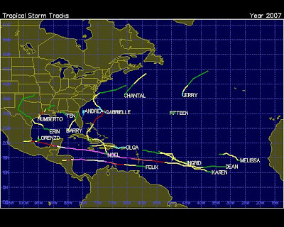
The 2007 Atlantic hurricane season would prove to be bizarre. Earth had lost its surface humidity and was struggling to cool itself.

The number of Killer Tornadoes in 2007 had increased to 26 and the current season of 2008's preliminary reporting so far is 27 and the season isn't over.

2007 saw seventeen named storms of which two were Cat 5, three Cat 1 and the rest were all Tropical Storm force.

The 'lay of the land' became very, very different. The storms were now forming where 'water vapor' was available along with enough heat to EVAPORATE the water to accumulate that water vapor, namely 'near shore' and on the Equator.

The two Cat 5 storms would occur where there was the most dense accumulation of water vapor and that was along the equator. The storms could no longer be sustained in their vorticity in the upper reaches of the Atlantic above the latitude of 15 degrees north. There simply wasn't enough water vapor and the 'near shore' storms took on many different formations including one storm which was literally 'upside down' in its traverse along the Eastern Seaboard of North America.

The 'reach' eastward into the Atlantic toward Europe of the storms nearly ended and with that the heat distribution of the Cat 5 storms was directed to latitudes of about 15 degrees north. Which means the waters of the 'Equatorial Earth' would sustain the highest deposit of heat. Realizing that, one has to remember the future of the predicted storms is that WHEN a hurricane will occur it will be with higher volatility. To realize the 'heat concentration' is now at 15 degrees north or less moving toward the Equator is to realize the degree at which these storms will increase in number while sustaining Cat 5 status chronically.

2006 saw a drastic reduction in the number of storms with ONLY nine.

The number of Killer Tornadoes in 2006 were 25 in the USA.

There were two Cat 3 storms that year. When examining the 'randomness' of the 'paths' of the hurricanes there was still widespread humidity to support the storms that did manifest. The 'paths' of the storms circulated throughout the Atlantic with the 'same' eastward path toward Europe as previous years. The climate of Earth was changing but with enough 'residual' coolness left over from 2005 to maintain a storm season that reached all areas of the Atlantic and HENCE distributing the heat on a greater surface area.

In the year 2005 when the USA population reached 300 million, there was a 'maximum' of hurricane activity and volatility.

The number of Killer Tornadoes in the year 2005 were 13 in the USA.

It was the 'Katrina' year. There were 31 named storms, three were Cat 5, two were Cat 4 and two were Cat 3. In 2005, there was still enough water vapor content at Earth's surface to 'handle the heat.' Earth's physics 'loaded' the troposphere with hurricane spawning capacity and the heat from Human Induced Global Warming was driven into the oceans.

The only glacier of the Juneau Icefields that is not retreating is the Taku Glacier.


Taku Glacier

The mass balance of the Taku Glacier has increased while ALL the other glaciers of the Juneau Icefields have eroded. The Taku Glaicer before Human Induced Global Warming resulted in 'maximum' manifestations of the years 2000, had the least 'RECHARGE' (deposits of snow and ice) of any of the glaciers.

Why then when Earth is warming and there is a climate crisis and weather patterns are changing would a glacier 'increase' in its volume?

This blog has referred to 'the properties of water' on numerous occassions. Water vapor is a 'component' of global warming. The 'heat transfer systems' I frequently refer to in explaining the increased rapid deterioration of the ice caps and icefields are 'powered' by water vapor. If Earth did not have water, it would simply be a 'hot rock' regardless of being 'the third rock' from the sun.

Percipitation on Earth is compliments of the properties of water. So, when it rains or snows or there is drizzle or ice storms it is all due to formations of water as it appears in regard to 'CLIMATE.' The colder the climate the colder the water, the more snow or ice that is formed.

When a glacier 'recharges' it means it accumulates more snow or ice. As the deposits increase over years the top layers become compressed as 'water' is very heavy. The top layers then are compressed into dense layers of ice and a glacier 'advances' and 'extends its terminus (front edge of the glacier that advances DOWNHILL.)

When a glacier recharges it REQUIRES percipitation. Percipitation to the degree it occurs over a glacier determines whether it advances quickly or not at all and actually retreats. So why then would all the other glaciers of the Juneau Icefields NOT recharge when the Taku Glacier is recharging? Seems odd that one would have such an exception and actually 'challenge' the 'idea' of Human Induced Global Warming since a theory or scientific law applies to all cases.

And what the heck does the Taku Glacier have in common with the increase in tornadoes and changing of the occurrence and intensity of hurricanes?

The Taku Glacier in Alaska's Juneau Icefields changed in its advance to the terminus because the mass balance increased. The MASS of the glacier increased due to increased percipitation over its 'area.'

The reason? Elevation/altitude, BUT, not in the way the average layperson would think and put that into context. To understand the brevity of the increase in percipitation over the Taku Glacier and its increased mass one has to 'think vertically.' Literally, one has to realize 'where the increased heat' of Human Induced Global Warming IS BEING STORED. It is being stored in the surface waters of Earth when hurricanes deposit the heat there and it is being stored 'vertically.'

When the heat from the surface was moving vertically through the troposphere the glaciers were exposed to higher temperatures and any percipitation that resulted in recharge was 'countered' balanced with LOSS of ice from the glacier in all areas, the terminus, the moraines and the top and bottom of the ice formations. The loss was far greater than the recharge and continues to be.

What occurred at the Taku Glacier was an increase in percipitation at already higher altitudes where the ice formation remained stable. When the increase in percipitation occurred it added to the mass balance of the glacier and explained the increase in the terminus. The real question became "Why is there more percipitation?" We know there was by weather records, but, also by the fact that a 'stable' mass balance of a very cold, higher elevation glacier would indicate that it was simply STABLE, in the face of hotter temperatures at lower elevations. But, for the mass balance to increase with the Taku Glacier and to increase its terminus there was only one answer. That answer was the increase in the deposit of snow and ice. The increase in the deposit of snow and ice could only occur in one way with the Taku Glacier. It would have to occur through percipitation as it is the highest elevation glaicer of the Juneau Icefields. What does that mean?

That means the 'dew point' (click here) at the altitude of the Taku Glacier had increased. The water vapor content of the altitude had increased and with the arrival of increased water vapor was the encroaching 'heat stores' of the lower latitudes that the other glacier were already exposed to and causing deterioration, retreat, decrease in their mass balance.

The relationship between the Taku Glacier and what is occurring in the troposphere is completely evident. The 'heat stores' of Human Induced Global Warming have risen in the troposphere and there is less and less water vapor at lower altitudes to support 'rain' and snow and ice, hence, causing widespread disruption in Climate. With increased water vapor at higher altitudes, the turbulence of the troposphere moves upward while 'drying' the surface and creating less biotic content.

Hence, the 'negative feedback loop' of Human Induced Global Warming that destroyes NECESSARY biotic content (plants) through lack of rainfall. Less 'albedo' of retreating icefields and ice caps, while, the consumerism of the USA continues to escalate the amount of carbon dioxide in the troposphere.

With higher elevations of turbulence is increased 'wind shear' AND less 'water vapor' at lower latitudes (sea level) to support hurricanes, therefore, less hurricanes and the ones that do eventually form will be more violent simply because of the higher ocean and air temperatures at the surface of Earth.

The Juneau Icefields of Alaska portray a very interesting picture as to the current and continuedly 'eminent' dangers of Human Induced Global Warming


This is a video of the fields as of December, 2006. There is grossly significant loss of ice formations throughout the elevations, EXCEPT, for one.

Heat. The increase of the Earth's surface due to increased levels of Carbon Dioxide is causing a 'shift' in weather patterns.

In their early and mature stages, all thunderstorms are characterized by rising air, called updrafts. These updrafts supply the warm, humid air that fuels thunderstorms. (click here)


The eye of a majestic hurricane is a very warm place to be. The air inside the eye is sometimes 15 to 20 degrees Fahrenheit warmer than the storm's surroundings. Where does all this hot air come from, and how does it power the hurricane's strong winds? (click here)

What is the difference between hurricanes and tornadoes? Speaking in terms of physics.


The 'ingredients' that go into these tropospheric turbulences are the same, however, the 'amount' of the ingredients are different. So is the surface area. It takes far more water vapor to support a hurricane than a tornado.
But.
Both are a result of vortices formed by heat driven tropospheric conditions. Tornadoes normally form over land while hurricanes form over oceans and dissipate over land.
The most common factor with these storms and their OCCURRENCE is 'Wind Shear.'
While those that benefit by 'explaining away' global warming in relation to 'weather' are served by separating the subjects and referring to ISOLATED incidences of past turbulence that are similar, the fact of the matter cannot be explained away, that "Wind Shear" serves to increase the occurrence of tornadoes and their frequency and number while it decreases that of hurricanes.


Recently there was a report that stated there would be less hurricanes due to 'Wind Shear.'

Wind shear is the change in wind speed or direction with height in the atmosphere. Wind shear is important for the formation of tornadoes and hail. Some amount of wind shear is common in the atmosphere. Larger values of wind shear exist near fronts, cyclones, and the jet stream. Wind shear in an atmospheric layer that is unstable can result in clear air turbulence.


Tornadoes occur with thunderstorms. There are a couple of ways that they form.

Most strong and violent tornadoes occur with supercell thunderstorms.

Thunderstorms occur when warm moist air is forced upward.

Tornadoes occur with a special storm type called a supercell.

Supercells occur with a certain wind conditions. Winds that turn from south to west with height and/or increase rapidly with height (especially in the lowest several thousand feet of the atmosphere) cause the updraft in a thunderstorm to rotate.

If the updraft is strong enough and the wind shear is strong enough, a tornado may occur. Supercells also produce large hail, strong winds and heavy rain.


Tornadoes - The Fujita-Pearson Scale
All tornadoes are rated on a scale called the Fujita-Pearson Tornado Scale.

F-0: 40-72 mph - Chimney damage, tree branches broken.
F-1: 73-112 mph - Mobile homes pushed off foundation or overturned.
F-2: 113-157 mph - Considerable damage, mobile homes demolished, trees uprooted.
F-3: 158-205 mph - Roofs and walls torn down, trains overturned, cars thrown.
F-4: 207-260 mph - Well-constructed walls leveled.
F-5: 261-318 mph - Homes lifted off foundation and carried considerable distances, cars thrown as far as 100 meters.

Tornado Outbreaks are RARE to say the least ! But, in the past eight years they are occurring with remarkable frequency !

The “Super Outbreak” of 1974 produced the most tornadoes in a 24-hour period in history (148). The most famous tornado from this outbreak was an F5 tornado that moved through Xenia, Ohio. Damages in Xenia alone totaled over $100 million. Total damages from the outbreak exceeded $600 million. 1979 April 10: Wichita Falls, TX


2003 May 4 – May 11: Plains Into The Southeast
A deadly outbreak of severe weather occurred between May 4th and May 11th, producing hundreds of tornadoes and widespread reports of large hail and damaging winds across eight states. Tornadoes affected the metropolitan areas of Kansas City and Oklahoma City, producing F3 and F4 damage. Other cities including Pierce City, Missouri and Jackson, Tennessee sustained heavy damage and loss of life. At least 38 people were killed from the outbreak in Kansas, Missouri and Tennessee. In Oklahoma City, damaging tornadoes occurred on both the 8th and 9th. May 1st through the 11th had more reported tornadoes (412) than any other ten-day period since records began in 1950. The estimated total damages from this historical outbreak totaled more than $3.2 billion.


Destruction at Toledo Scale Company, Telegraph Road.
Photo courtesy of Toledo Lucas County Public Library


Twin funnels in Elkhart, Indiana on April 11, 1965. A double tornado was also sighted near Toledo during this tornado outbreak.
Photo courtesy of National Oceanic and Atmospheric Administration/ Department of Commerce
Call Number: wea00217 Historic NWS Collection

Not just four day of tornadoes. Four Days of Tornado Outbreaks.

But, after all, this is the USA and we can control most of the nasty outcomes of nature. Who really cares about tornadoes anyway, it only happens in Kansas.


1953 June 8: Flint, MI (The 1950s when oil was dirt cheap and air quality was beginning to find its way to concern for Americans. Smokestacks were beginning to be a blight on the country and children's lungs. The Industrial Revolution from the late 1800s was in full swing with two World Wars behind us and a Korean Conflict winding down.)
Over $19 million in damage occurred as an F5 tornado moved through the northern sections of Flint, MI. 115 people were killed and 844 were injured. This tornado was the last single tornado through March 2002 to cause more than 100 deaths.


While there is no single agreed upon definition, generally more than six tornadoes in a day in the same region is considered a tornado outbreak. A series of continuous or near continuous tornado outbreak days is a tornado outbreak sequence.
The largest tornado outbreak on record — with 148 tornadoes, most significantly including six F5 and 24 F4 tornadoes — occurred on April 3 - April 4, 1974 across the United States and Canada. It is dubbed the
Super Outbreak.