Monday, August 29, 2011

I have yet to witness the abilities of Nic Robertson in the Middle East by another journalist.

Tripoli, Libya (CNN) -- Nothing could have prepared me for what I'm about to see.
I'm in a fancy villa in a posh part of Tripoli, walking through the garden past a huge plastic children's swing set and a trampoline that dominate the lush green lawn. A young man is filling a large swimming pool.

All this in a city where water is running out. I've not had a shower or washed in running water for three days. The al-Megrahis, it seems, are not short of money.

This villa connects to another, equally palatial but far more contemporary. It's clad in modern ceramic tiles, like something you'd see in trendy London neighborhood.

As I walk up the grand staircase towards the front door, I'm mentally composing my questions -- what I'll ask Abdel Basset al-Megrahi first. Did you do it? Did Gadhafi give you the orders?

I've been waiting for the moment for a long time....


Nic Robertson: Bin Laden interview (click here)

November 11, 2001 Posted: 11:00 AM EST (1600 GMT)

I am quite certain he is the journalist of choice to many in the Middle East.  In the instance with al-Magrahi; the rebels and the family needed to make it known to a global community that indeed the decisions regarding extradition were the only ones to make.  So, they turned to a trusted journalist.  Nic is more valuable than he can ever be paid.  Dedication is invaluable and marked with status and not pieces of gold.  

New York did well.

But, there watersheds are met with high rise structures with a geographical small food print accompanied by large tracks of open space.  I thought the Mayor carried out plans for protecting citizens 'just right.'  I was a wonderful opportunity to keep people safe and examine their disaster plans.  Well done.

What does Vermont and New Jersey have in common?


Stone.  Not being stoned. but, stone.
Vermont has mountains that drain rain into a watershed and New Jersey has concrete that drains rain into a watershed.
One could say, Vermont is natural flooding and New Jersey is man-made flooding.

August 29, 2011 8:30 AM


LINCOLN PARK, NJ (CBSNewYork/AP) – The flooding left by Tropical Storm Irene is not over yet – and it may even get worse for some before it gets better.

That’s because many of New Jersey’s swollen rivers are set to crest today.
Main street in Lodi turned into a river. The water flooded basements of many area homes….


Vermont Flooding Spares Few In Statewide Disaster (click title to entry for audio link - thank you)

Monday, 08/29/11 7:34am
Ross Sneyd
(Host) Tropical Storm Irene washed into Vermont with torrential rains that spread floods from end of the state to the other.
The storm dropped four to seven inches of rain in just a few hours and sent rivers raging through town after town.
As VPR's Ross Sneyd reports, the scope of the devastation drew comparisons to the historic 1927 floods.
(Sneyd) The toll in lives disrupted, property damaged and nerves frayed is staggering.
And Scott Whittier of the National Weather Service says it's historic.
(Whittier) "'73 was a signifidant flood across the state. Before that was '27. Now you're talking 2011. So we get these maybe every 40, 50 years. So it's pretty much a once-in-a-generation type of flood."
(Sneyd) Up and down the state, town after town was swept by the relentless rains of Irene. Rivers flooded, roads washed away and bridges gave way…

Watersheds are where drinking water is obtained.  With Irene, 'surface area' + 'rainfall' / 'watershed' = flooding

Vermont's watersheds are effected by mountains and elevation.

New Jersey has far less areas of 'absorption' so the 'overland flow' is high.  Therefore, the watershed is effected by lack of open space PER person and hence flooding.  

Sunday, August 28, 2011

I have plenty to post...

...but, it isn't appropriate right now.  


Tomorrow.


Thank you.

Isolated locations like the Barrier Islands of NC and distant places in Vermont may need helicopters from the Coast Guard AFTER the hurricane passes.

That is especially true for medical transportation if there are no passable bridges or roads or flooding is expected to continue.


Thank you.


Irene Sweeps Flooding, Havoc Across Vermont (click title to entry - thank you)

Sunday, 08/28/11 4:04pm


(Host) Tropical Storm Irene has swept flooding and destruction across Vermont.  One woman is missing and was last seen floating in the Deerfield River.
As VPR's Ross Sneyd reports, state officials say no one should be on the roads at this hour.
(Sneyd) From the Deerfield Valley in the south to the Champlain Valley in the west, Irene is dropping tremendous amounts of water.
And the water is jumping its banks, undermining roads and creating havoc.
Transportation Secretary Brian Searles says Vermonters should not head out, even if the rain stops....


Taking the time to 'talk reality' has its reasons.


Of the Big Cities, Philadelphia Is Hard Hit

This article was reported by Kim SeversonBrian Stelter, Dan Barry, Sabrina Tavernise and Campbell Robertson and was written by Stuart Emmrich. (click title to entry - thank you)


...In Philadelphia, which lies between the Schuylkill and Delaware Rivers, residents in low-lying areas woke up to rising water. Mark McDonald, spokesman for the Philadelphia mayor, Michael Nutter, said water levels were 15 feet above normal in some areas, and were not expected to stop rising until 2 p.m. Sunday. The waters were approaching the highest level ever recorded — 17 feet in 1869, he said. “There are many streams and creeks, and they are all above flood stage now,” Mr. McDonald said by telephone.
The storm, which dumped at least six inches of rain on the city, caused the collapse of seven buildings there, he said. Though nobody was injured, at one building — a six-story structure at 734 South 17th Street, just south of Center City, 20 residents had to be evacuated to safety. The airport, which closed at 10:30 Saturday night, would probably not reopen before late Sunday afternoon, Mr. McDonald said, though subways and buses would begin running around noon....


Known (click here) as the City of Brotherly Love, Philadelphia, Pennsylvania, (click here) has one of the richest histories of any city in the United States. The city was founded in 1681 by Captain William Markham under the direction of William Penn, who saw the area as a refuge for Quakers. Philadelphia quickly became the cultural and industrial center of the then British colonies. From 1774 to 1776, the First and Second Continental Congress convened in Philadelphia to discuss uniting the colonies and breaking away from the British Empire. In 1776, the Declaration of Independence was signed in Independence Hall, located in the heart of the city. Philadelphia served as the capital of the United States from 1781 until the national government moved to Washington, D.C., in 1800.
Today, the Philadelphia metropolitan area houses a population of more than 6 million people and remains one of the industrial centers of the country. In the above image, the Delaware River, which separates New Jersey from Philadelphia, can be seen running along the southeastern edge of the city. Developed areas in and around the city are gray. The patchwork of off-white and green land around the city is farmland. The dark brown areas in the lower righthand corner of the image are the Pine Barrens, which are wetlands in western New Jersey.
This simulated color image was acquired by the Landsat 7 Enhanced Thematic Mapper plus (ETM+) on April 24, 2000.

CNN states 15 dead in 6 states. That seems like a lot for a Cat 1 storm.


Hurricane Irene had led to the deaths of 14 people in five states as of this morning: (click title to entry - thank you)
VIRGINIA
A King William County man killed when a tree fell on him is the fourth confirmed fatality related to Hurricane Irene. Virginia Department of Emergency Management officials say the man was cutting a tree when another fell on him shortly before 8:30 p.m. Saturday.
Newport News authorities report that 11-year-old Zahir Robinson was killed when a large tree crashed through his apartment shortly after noon. He was pronounced dead at the scene. The boy's mother, who was in the apartment, was not injured....
North Anna Power Station, Virginia

Aug 28 (Reuters) - Dominion Resources (click here) reduced output to 50 percent at its two-unit 2,100-megawatt Millstone nuclear power generating station in Connecticut on Sunday as Tropical Storm Irene moved through the state, a company spokesman said.
The units began reducing output ahead of the storm on Saturday to help maintain grid stability in the event that severe wind reached the station, the company said.
"Reducing power helps maintain grid stability because in the event that the units go offline, there will be less of a shock to the grid if they are not operating at 100 percent," said Kenneth Holt, a Dominion spokesman. 
(Reporting by Eileen O'Grady and Jeanine Prezioso; Editing by Marguerita Choy)

This was yesterday in North Carolina. "...and the sea turned to foam."


Waves crashed into Avalon Pier as Hurricane Irene struck Kill Devil Hills, N.C., on Saturday.

This storm has no intention of slowing down. It is better defined now than ever.

August 28, 2011
1140.17z
UNISYS Infrared Northeast USA Satellite (click title to entry - thank you)


I believe what is being seen at this point is a reduction in its diameter which will concentrate the remaining velocity in a tighter circle.  Another way to say it, is that the 'spinning top' will be fueled by its own 'energy' being drawn into its center.  It is why the 'loft' of the center clouds is higher.  


From the media coverage (and I looked at most if not all of it) the areas being hit that have buildings, walkways and amusement rides are going to have to be inspected before use again.  There is some real power in that storm surge, so it cannot simply be treated as flooding, it is more than that.  It is like the water is turned into a 'propulsive' INSTRUMENT.  Water can take on the characteristic of 'bullet like' or 'torpedo-like' velocity.  So, basically where the impact of the tides are happening is like an object hitting it, not just flooding.


The storm is still receiving 'hot water vapor' as fuel from the tropics as well.


August 28, 2011
1230.14z
UNISYS Water Vapor Goes East Satellite (click here for 12 hour loop)


The loops may not be perfect as UNISYS stated there may be some interruption of the signal during the storm.  They are doing a great job though.  It isn't as interrupted as one might expect.


I believe as the hurricane heads north to the Arctic Circle it is transforming a bit to what most meteorologists call "A Mid-Latitude Vortex."  See, the dynamics for those vortices are already at work on a chronic basis.  While expecting Irene to diminish into a Tropical Storm is correct as it enters cooler latitudes and waters is correct, that is not taking into consideration the "Climate Crisis" dynamics that is supporting it as well.  Irene will remain a high velocity vortex all the way into the Arctic Circle no different than the 'usual' vortexes do on a daily basis.  Irene especially will because of an inexhaustible water vapor flow off the Equator.


Canada is going to receive these winds as well.  The summer of 2011 is going to result in a large loss of ice in the Arctic Ocean due to this hurricane.  Years ago, and I can find the date in my notes, there was a hurricane that went in the peninsula resulting in incredible loss of ice.  That is exactly what is going to result here.


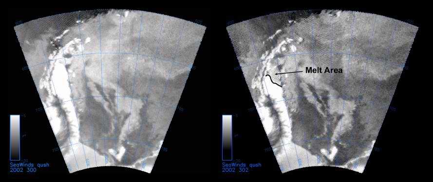
The year was 2002, Antarctica Peninsula.  I'll try to find the image, but, this is the release from NASA.  The image is below and click the highlighted article link below.  Thank you.


The storm that caused this melting on the Peninsula in 2002 started south of Australia and I have that saved on an old disk.  I am not gong to get it out now.  It requires a computer that reads that disk and I don't have it turned on at the moment.  But, I watched it roll across the coldest ocean in the world to land directly on the Peninsula without contact with any other land mass.  I am sure there were some ship warnings for the region at the time.  But, it was a hurricane.  It had an 'eye.'  I don't believe it ever received a name.  That is what is being witnessed now with Irene.  Irene is headed for the Arctic Circle to 'cool off' and cost Earth more of its ice reserves.

The SeaWinds instrument on NASA’s Quick Scatterometer (QuikScat))click here) spacecraft captured these near-real-time backscatter images of melting on the Larsen C ice shelf in Antarctica’s Weddell Sea between October 27 (left) and October 29 (right), 2002--the earliest documented melting event on the ice shelf since radar data began to be collected in the late 1970s. The melting extended as far south as 68 degrees south and resulted from a cyclone that delivered warm air to the region. The image on the right also shows a noticeable recession in the sea-ice margin to the west of the Antarctic Peninsula. The darker grey values of the melt region indicate radar backscatter coefficients that are reduced by approximately 10 decibels from their typical end of winter values.


Saturday, August 27, 2011

I was speaking to someone from Philadelphia, Pennsylvania about 4:45 today.

He asked how things were in North Carolina because of the hurricane.  So, I told him.  Then I stated you take care with it coming your way.  He stated, it isn't going to be that bad here.  I then spoke with him another 15 minutes to convince him he had to take things more seriously and listen to any warnings and evacuations.  


Sometimes folks just don't do the right thing no matter how hard others try.  


The roads are still flooded in Wilmington, NC


If the game is called off because of a hurricane, I would think people would 'get serious.'  Whatever.


 — At least the Phillies can't be accused being "wusses.'  (click title to entry - thank you)
With Hurricane Irene bearing down on Philadelphia, the Phillies tried to play ball Saturday. They opened the gates at Citizens Bank Park, let the fans in and sold a few cheesesteaks.
But the rains from Irene's northern bands came around noon and never stopped. Around 1:20 p.m., 15 minutes after the scheduled first pitch, came the announcement over the PA system that the game was postponed....

Latest report from family in Wilmington, North Carolina:

...all are safe.  There was a lot of debris flying around and a lot of limbs down.  No damage to vehicles.  Electricity was out for five hours and some of the children's milk products have to be thrown out to be on the safe side. ( One of the children has a special diet and her refrigerated food can only be without refrigeration for 2 hours. )  A lot of flooding, Figure Eight Island is closed.  They will venture out on the roads in a few hours,   

It is hitting some drought areas. I can't believe this is 90 mph with that much loft.

August 17, 2011
1040.17z
UNISYS Infrared Atlantic States Satellite Image (click here for 12 hour loop)

It is a rainmaker.  In the loop of the satellite at the link above it is easily discerned how condensed the eye became and increased loft as it approached landfall.  


Raleigh, NC - Hurricane Irene click title to entry - thank you) slammed into North Carolina's coast around dawn Saturday with howling winds and drenching rains amid reports of flooding and tens of thousands of people without power.
The center of Hurricane Irene is expected to hit the Outer Banks around lunchtime.
Irene claimed it's first victim Friday night when a 22 year old surfer drowned after being caught in a rip current off the coast in Virgina Beach.
tornado watch was issued for parts of Virginia until 11 a.m. Saturday. Included in that  watch is Northampton County in North Carolina.
Just after 10 p.m. Friday night a tornado touched down in Belhaven, NC in Beaufort County.  The tornado did structural damage to multiple trailers and ripped the roof off of a car dealership.
A second tornado was reported early Saturday morning in Tyrrell County near Columbia, NC.  Structural damage was done to buildings and some injuries reported.
The latest advisory from the National Hurricane at 3am Friday has maximum sustained winds at 90 mph, making it a Category 1 hurricane on the Saffir-Simpson hurricane wind scale.
No significant change in strength is forecast before Irene reaches the coast of North Carolina, and some weakening is expected after landfall....
The power of the storm is best noted  due to its sustained 'area.'  It isn't minor physics that is maintaining a storm at 90 mph winds with such a large footprint.  That's why it is difficult for any weather service to simply say this storm isn't 'all that.'  It is 'all that.'  And it changes so unpredictably that it can NOT be trusted in what will happen next.  In that short 12 hour loop it changed its entire character and once it passes over land and goes back so sea it will change again.  Taking care of people and property during these events isn't efficient, but, it is prudent.  That is something the public sometimes does not appreciate.  A surfer in Virginia died due to rip currents caused by this storm hundreds of miles away and it wasn't for the lack of warning.  Why do people think they know more than what is told them?

Friday, August 26, 2011

Ron Paul said what in commentary on FEMA in relation to "Irene?"

"We (the federal government) aren't responsible for citizen safety that is why we have the 2nd Amendment."

Amendment 2 - Right to Bear Arms
A well regulated Militia, being necessary to the security of a free State, the right of the people to keep and bear Arms, shall not be infringed.

The reason the Right Wing 'gets away' with this insanity is because there are enough people that are sane.  Amazing.


FRIDAY, AUG 26, 2011 18:15 ET
Ron Paul (click title to entry - thank you) on hurricane response: "We should be like 1900"
After a lunch speech today, Ron Paul slammed the Federal Emergency Management Agency, or FEMA, and said that no national response to Hurricane Irene is necessary.
"We should be like 1900; we should be like 1940, 1950, 1960," Paul said. "I live on the Gulf Coast; we deal with hurricanes all the time. Galveston is in my district.
Paul doesn't support FEMA because of "moral hazard." The fact that people will receive help should a natural disaster strike encourages people to live where natural disaster happen. (Like "North America.") Paul is mostly talking about the National Flood Insurance Program, which definitely has glaring flaws as public policy, but abolishing the federal agency in charge of responding to natural disasters instead offixing the problems with one program that agency oversees seems like overkill.
  
I suppose we don't need clean water, clean air, a safe food supply or Homeland Security.  Right?  He is one of the Right Wing crackpots.  I suppose Galveston just needs to 'build 'em better.'  He should tell that to his constituents which frequently turn to FEMA for financial relief.  


Galveston County to Receive Additional Assistance for Infrastructure (click here)

Release Date: October 1, 2008
Release Number: 1791-069

AUSTIN, Texas -- The Federal Emergency Management Agency (FEMA) has expanded disaster assistance to Galveston County to help pay for repair, restoration, reconstruction or replacement of public facilities, roads and bridges, water facilities and other infrastructure damaged or destroyed by Hurricane Ike.
After further review of damages and assessments, Galveston is now eligible for all categories of FEMA Public Assistance as well as Individual Assistance.
Under the cost-share program, FEMA Public Assistance reimburses 75 percent of the cost for eligible work by state and local governments and certain non-profit organizations that provide public services. The state manages the grants for all projects. The remaining 25 percent non-federal share comes from state and local sources.
President Bush declared a major disaster declaration for Texas on Sept. 13. Public Assistance categories A and B, for debris removal and emergency protective measures are available to Galveston and 28 additional counties: Angelina, Austin, Brazoria, Chambers, Cherokee, Fort Bend, Grimes, Hardin, Harris, Houston, Jasper, Jefferson, Liberty, Madison, Matagorda, Montgomery, Nacogdoches, Newton, Orange, Polk, Sabine, San Augustine, San Jacinto, Trinity, Tyler, Walker, Waller, and Washington. 
Additionally, President Bush authorized 100 percent reimbursement of the cost of debris removal and emergency protective measures for the first 14 days after the disaster declaration....

Why didn't Ron Paul stop this?  This is October 2008 when the banking crisis was in full swing and the Nation's Debt was the highest it had been in eight years. 


and the approximate 2000 deaths elsewhere is that there was no evacuation, because this category-4 storm caught people by surprise. There was not an outside warning, and the populace did not recognize early, local indicators. Ironically, as the storm approached, many people gathered at the beach to watch the high waves....


Those statements by Ron Paul are barbaric, cruel and irresponsible.  He is a nut case.  What a stupid thing to say with the entire East Coast of the USA facing danger for its citizens.  Irresponsible is not even the word to use.  This has to be the quintessential example of the moronity of the Right Wing and their ignorance to their own history.  The history of CARING FOR CITIZENS facing disaster dates back to 1803.  I would think that would be close enough to 1776 to understand the intentions of the Founding Fathers of the USA.


Emergency Management History (click here)
The is considered the first piece of disaster legislation.  It provided one New Hampshire town with assistance after an extensive fire.  In the century that followed, ad hoc legislation was passed more than 100 times in response to hurricanes, earthquakes, floods and other disaster. 

I don't know where the Right Wing carries their brains, but, it is not in their head.  It doesn't get worse than this.  Statesmen?  They aren't statesmen, they are the electorate's idea of entertainment.  The electorate must measure their appropriateness for office by the laugh they get from their speeches.  They don't need ballot boxes, they just need laugh meters.

We are doing well so far. Past Florida and Georgia. A big thank you for all those responsible for our safety and that includes the media.

That storm is moving.  Wow.  


In High Point, NC the air feels like the beach, partly cloudy, high humidity and 'sticky.'  

August 26, 2011
1530.13z
UNISYS Water Vapor GOES East Satellite  (Click here for 12 hour loop)

I saw Mayor Bloomberg on the news yesterday evening.  He was obviously worried for everyone and doing all New York's Finest could do to safeguard all citizens.  I felt badly that he had such a huge responsibility, but, he carries out his care of his citizens with great brevity.  I am confident all the mayors are doing the same thing along the path of this hurricane.  One hundred mile per hour winds are not 110, but, they still carry concern.  


The storm surge worries me.  This is a huge storm and it is pushing storm surges for quite a distance.  Its power is distributed along a wider 'surface area' but it is still considerable when one realizes the surface area that is still sustaining 100 mph winds.


If one cannot be happy then they can be happy they are safe.


This is where it started.  The image is from the Boston Globe.