1140.17z
UNISYS Infrared Northeast USA Satellite (click title to entry - thank you)
I believe what is being seen at this point is a reduction in its diameter which will concentrate the remaining velocity in a tighter circle. Another way to say it, is that the 'spinning top' will be fueled by its own 'energy' being drawn into its center. It is why the 'loft' of the center clouds is higher.
From the media coverage (and I looked at most if not all of it) the areas being hit that have buildings, walkways and amusement rides are going to have to be inspected before use again. There is some real power in that storm surge, so it cannot simply be treated as flooding, it is more than that. It is like the water is turned into a 'propulsive' INSTRUMENT. Water can take on the characteristic of 'bullet like' or 'torpedo-like' velocity. So, basically where the impact of the tides are happening is like an object hitting it, not just flooding.

August 28, 2011
1230.14z
UNISYS Water Vapor Goes East Satellite (click here for 12 hour loop)
The loops may not be perfect as UNISYS stated there may be some interruption of the signal during the storm. They are doing a great job though. It isn't as interrupted as one might expect.
I believe as the hurricane heads north to the Arctic Circle it is transforming a bit to what most meteorologists call "A Mid-Latitude Vortex." See, the dynamics for those vortices are already at work on a chronic basis. While expecting Irene to diminish into a Tropical Storm is correct as it enters cooler latitudes and waters is correct, that is not taking into consideration the "Climate Crisis" dynamics that is supporting it as well. Irene will remain a high velocity vortex all the way into the Arctic Circle no different than the 'usual' vortexes do on a daily basis. Irene especially will because of an inexhaustible water vapor flow off the Equator.
Canada is going to receive these winds as well. The summer of 2011 is going to result in a large loss of ice in the Arctic Ocean due to this hurricane. Years ago, and I can find the date in my notes, there was a hurricane that went in the peninsula resulting in incredible loss of ice. That is exactly what is going to result here.
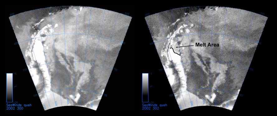
The year was 2002, Antarctica Peninsula. I'll try to find the image, but, this is the release from NASA. The image is below and click the highlighted article link below. Thank you.
The storm that caused this melting on the Peninsula in 2002 started south of Australia and I have that saved on an old disk. I am not gong to get it out now. It requires a computer that reads that disk and I don't have it turned on at the moment. But, I watched it roll across the coldest ocean in the world to land directly on the Peninsula without contact with any other land mass. I am sure there were some ship warnings for the region at the time. But, it was a hurricane. It had an 'eye.' I don't believe it ever received a name. That is what is being witnessed now with Irene. Irene is headed for the Arctic Circle to 'cool off' and cost Earth more of its ice reserves.
The SeaWinds instrument on NASA’s Quick Scatterometer (QuikScat))click here) spacecraft captured these near-real-time backscatter images of melting on the Larsen C ice shelf in Antarctica’s Weddell Sea between October 27 (left) and October 29 (right), 2002--the earliest documented melting event on the ice shelf since radar data began to be collected in the late 1970s. The melting extended as far south as 68 degrees south and resulted from a cyclone that delivered warm air to the region. The image on the right also shows a noticeable recession in the sea-ice margin to the west of the Antarctic Peninsula. The darker grey values of the melt region indicate radar backscatter coefficients that are reduced by approximately 10 decibels from their typical end of winter values.