 January 16, 2007
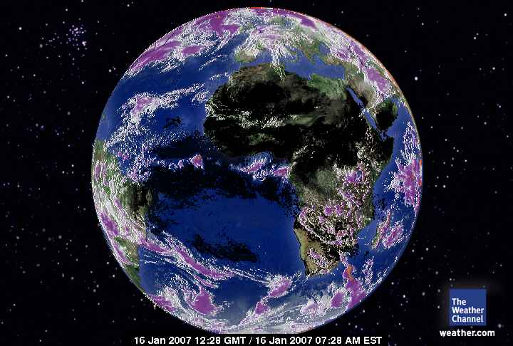
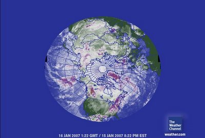
0122 gmtThe same high amount of humidity is noted by increased cloud cover over the Arctic Ocean as was noted over Antarctica. There is so much melting of the ice cap that nearly the entire Northern Hemisphere is coverd in clouds. The exception is where? The Mediterranean Sea and North Africa. The other interesting reality of this satellite picture is to note North America. The western USA has less cloud cover than the east. There are also far lower carbon dioxide levels there compared to the eastern USA. Some of the reason for that is because the Pacific Ocean doesn't produce carbon dioxide but as the wind pushes the air from the USA eastward the CO2 accumulates over distance. 
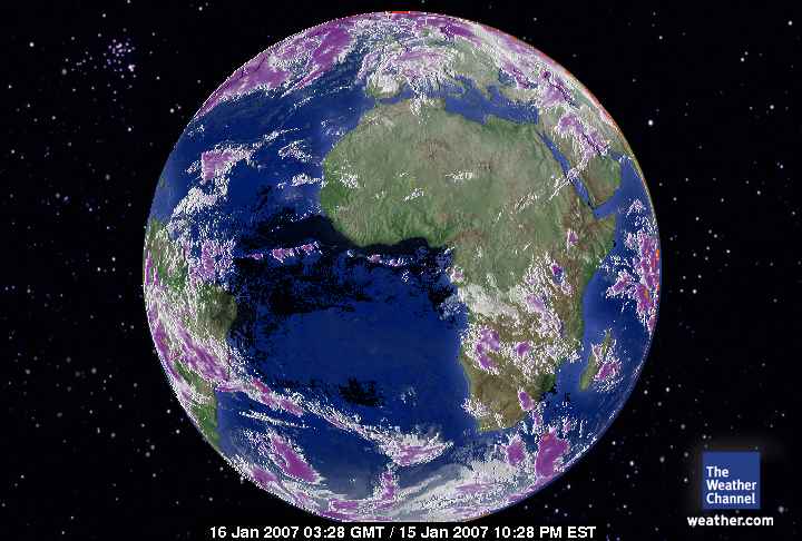
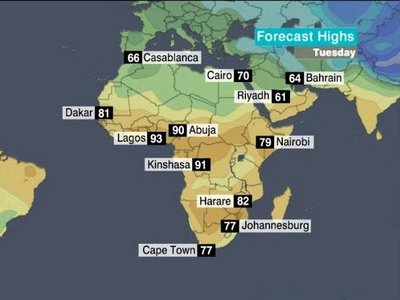 Cape Town57/77 F Dakar68/84 F Dar es Salaam77/90 F Johannesburg60/82 F Lagos76/92 F Marrakesh46/71 F Nairobi49/78 F Tripoli48/64 F Tunis49/71 F These are seasonally mild temperatures with a wide range of temperatures between night time lows and daytime highs. Healthy. The wider the variation the less water vapor to temper the 'shift' of temperatures from sunlight to it's absence. Very nice. The way it should be. LIVEABLE. The water vapor from Antarctica or the Arctic Ocean is not over Africa at all ! Not enough carbon dioxide. Africa is a huge landmass but is not experiencing the residual effects as the land mass of North America does. The drought however can be significant and has to be addressed by the global community. This is NOT their problem !
 January 16, 2007
1228 gmtThis is amazing. The troposphere over Africa is actually cooler than anywhere else on Earth. Africa doesn't have a large water distribution as a consequence and will be experiencing severe drought due to every other INDUSTRIALIZED nation's pollution. The African people plant trees to facilitate a carbon sink for Earth. It shows. People with a conscious and consequently some of the most abused societies that reflect the nature of the people there.
 January 16, 2007
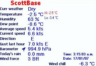
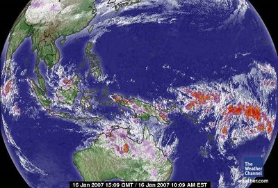
1509 gmt
West Pacific Satellite
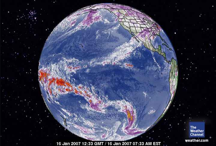
This shows the heat source from the Pacific finding Antarctica a very nice target. You know Bush wants to point a finger at China as a problem to Human Induced Global Warming. He could fix that, but, having his State Department impose requirements to facilitate clear air and water including carbon dioxide emissions IF he was willing to make that a part of the relationship with the USA in treaties with China. He won't do that because the Bush Family Fortune IS China and Asia. To impose standards on them would be like shooting himself in the foot. This administration has huge conflicts of interest, from Halliburton to China to telecommunications. These circumstances directly reflect the personal goals of power brokers in office in the USA.
 January 16, 2007
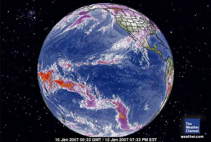
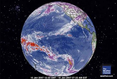
Pacific Global SatelliteSlightly improved from 12 hours ago, but, this is hugely bad. Where does anyone get the almighty nerve not to reconcile government policy to reflect reverence for Earth and it's precious climate. This is unconscionable.
 January 16, 2007 0033 gmt Pacific Global Satellite
 January 16, 2007
1323 gmtAntarctica is experiencing a lot of cloud mass which of course we all know acts as an insulator. The largest heat transfers are coming in across the Pacific at 10 o'clock and off South America at 2 o'clock. Just left of 6 o'clock appears to be a tornado like air mass coming from Australia.
 January 16, 2007
0123 gmtAntarctica 12 hours ago. Very little change. There is a lot of condensation of water vapor over East Antarctica where the lowest homogenous temperatures are currently. Water vapor holds heat in the form of clouds.
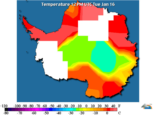
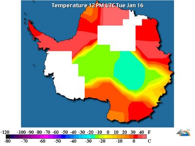 The temperatures across the ice continent are high. This is grossly abnormal for Antarctica.The heat surrounding Antarctica is becoming a greater force than any of it's ability to be cold. The temperature is becoming equitable throughout the ice continent. The coldest temperature is -17 C (click on) at Vostok and Dome C. The next highest is -13 C at Amundsen-Scott and Casey. The next highest is -7 C at Henry and Nico. The remaining reporting stations show temperatures above freezing with the highest 42 C at Maitri. These are homogenous temperature.The winds are very calm (click on) and the jet stream/vortex (click on) is bring the heat in and equally distributing the heat around the ice continent. Antarctica is subliming in a very big way.
The weather at Glacier Bay National Park (Crystal Ice Chime) is temperate:
Elevation : 33 feet / 10 meters
Temperature : 32 degrees Fahrenheit / Zero Centigrade
Conditions : Mostly cloudy and that is what has the area warm. Clouds are insulators.
Humidity : 80%
Dew Point : 27 degrees Fahrenheit / -3 Centigrade
Wind : 9 mph / 15 km./h / 4.1 meters per second from the Southeast
Pressure : 30.03 inches / 1017 hPa
Windchill : 24 Fahrenheit / -4 Centigrade
Visibility : 7.0 miles / 11.3 kilometers
UV : 0 out of 16
Clouds : These clouds are in layers at the designated altitude above ground level.
Few 200 feet / 60 meters
Scattered Clouds 1000 feet / 304 meters
Mostly Cloudy 1500 feet / 457 meters
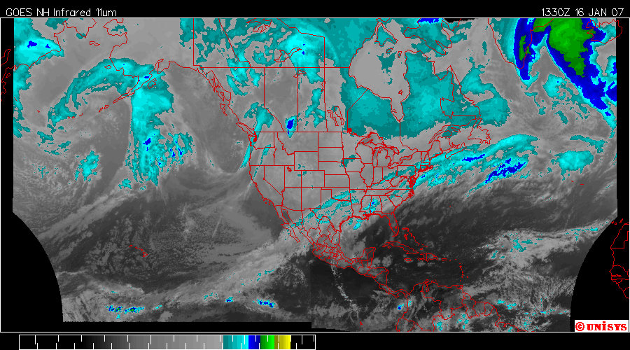
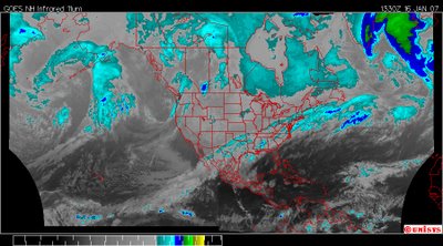 January 16, 20071330 zEnhanced Infrared Satellite from UNISYS.The pattern has little to no change and will exponentially maintain this status for awhile as there is an inertia component to the vortices. Note in both satellite pictures that the equatorial 'heat transfer system' cross North America, a warmer, higher energy 'system area' under a thick blanket of carbon dioxide. What drives Human Induced Global Warming? Carbon dioxide. Where it is the thickest will be the areas most warm with higher energy for air movement. The nearest ice mass is Greenland and that is exactly where the hottest air will find resolve, hence a low pressure system and a vortex.Where the severe weather is manifesting is along the area of cold air front. It's solidly arctic air. The inertia of the system off the equator will delay any change in the arctic front behind it.
 January 16, 2007
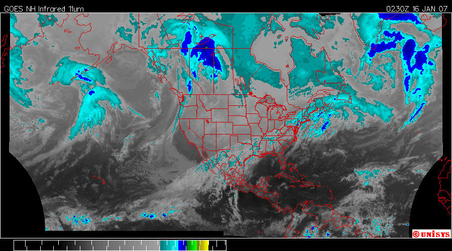
0230z Enhanced Infrared Satellite from UNISYS. A very hot and destructive tropospheric system is moving hot air from the equator to the Arctic Circle. These are huge distributions. The hot air is forcing the arctic air down to the lower latitudes because it is heavier and sinks while the ligher, hotter air rises to displace it. The hotter air has more mass but less density than the arctic air and that is why the displacement is possible.
 Janury 15, 2007
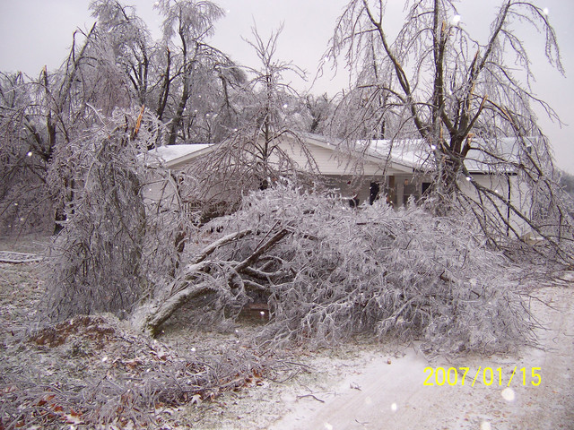
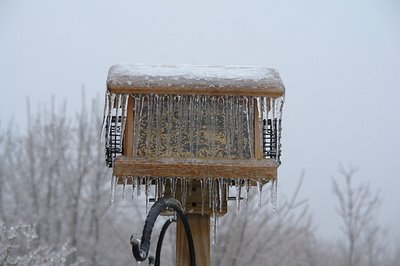
Fordland, MO
Photographer states :: Ice storm damagePhotographer doesn't have much to say. Sounds like shock. Huge amount of biotic damage. Not only that but the longer the ice remains on that house the more difficult it will be to heat for the occupants. The ice will literally suck the heat out of the house while it sustains it's form from the cold weather. The cold air will maintain the ice at the cost of the heat in the house. This is very dangerous stuff. I really like wool. A lot. Wool coats, mittens and especially wool blankets. I have this awesome Icelandic Wool blanket about a quarter inch thick and that is literally all I have to put over me even when the heat is off. It holds my body heat just like I was the sheep itself. It has a pretty design of brown and beige horses running wild on it. Love that blanket. It's not a bit bulky that kids wouldn't want it on them or create a danger to a small person/child hiding under it.
 January 15, 2007
East Bloomfield, New York
Photographer states :: Pretty scene, trees await the warm air to finally come in.So long as the branches and trunks are not cracked or split from the weight of the ice; the evergreens will probably be okay.
 January 15, 2007
East Bloomfield, New York
Photographer states :: The obligatory bird feeder shot.Very strange to have EXACTLY the same weather at opposite ends of the country.
 January 15, 2007Tolar, TexasPhotographer states :: Grass!!!!!!!!!!!Some fill light was added to see the grass within the ice. It depends on the species but any grass native to Texas I know of won't weather this storm. I hope there aren't animals waiting to graze anytime soon.
 January 15, 2007
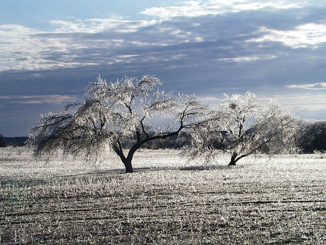
Tolar, TexasPhotographer states :: The ice was very thick on the tree limbs!There is some significant damage regardless of how pretty and breathtaking it might be.Elevation above sea level - 778 feetCurrent conditons :: Temperature - 27 °F / -3 °C
Conditions - Clear
 January 15, 2007
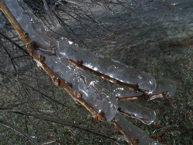
Tolar, TexasPhotographer states :: Ice storm...My camera couidn't capture the sparkling ice crystals shimmering in the sun!!! -it was breathtaking!!!!!!!!!!!
 January 16, 2007
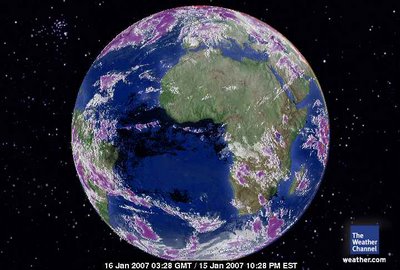
0328 gmt Africa - Europe SatelliteThe air over Africa cannot support the humidity needed currently to for storms. Even the jungles of the Congo are dry.