Thursday, September 15, 2005


September 15, 2005. My poor Africa. Hot. Very Hot over it's sand masses called deserts. Few clouds. Why? Because. Because Africa is not a carbon dioxide emitter. There is a vortex flow from the equator over the very eastern border of Africa heading north over Europe.  Posted by Picasa

September 15, 2005. The Western Pacific at East Asia. Well, look at all this mess. Why? Because. Because China is moving to take over Britain as the second largest carbon dioxide emitted right behind the USA.  Posted by Picasa

September 15, 2005. Western Pacific. There is a votex connection across Australia. Why? Because. Because Australia is a carbon dioxide contributor and not a signator ot Kyoto.  Posted by Picasa

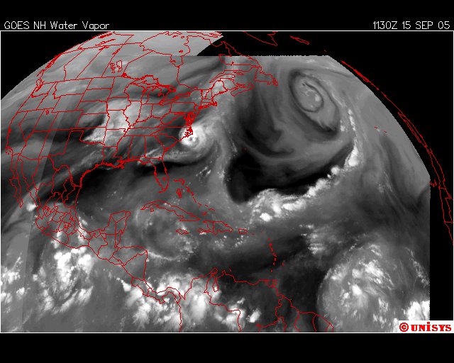
September 15, 2005. Pacific Global Satellite reveals and encroaching hotter Western boundary as the equinox approaches. There ia a disconnect between the Antarctic Vortex and the Equator. That is highly desirable. The ice caps cool the oceans which in turn cools the continents by circulation of the waters. What began on October 2, 2002 was a cooling of the planet by air turbulence. Air turbulence leads to severe weather and climate change as well as accelerated and dangerous heating of the oceans. We need to keep the air masses of 'equatorial' and 'arctic' separated. The means the carbon dioxide level of Earth needs to be rolled back until that 'static' safety zone is achieved.  Posted by Picasa

September 15, 2005. This view of the Western Hemisphere is far less threatening compared to the analysis and scrutiny below.  Posted by Picasa

September 15, 2005. The GOES EAST dynamics is easily discerned here. Also of interest which repeats itself in the water vapor below is a 'depression' between the Yukatan Peninsula and Cuba. The cooler aire masse of the western side of the satellite is still consistent. The 'dippling' is still apparent developing into small vortices. Also noted a huge supercell developing over the North Pacific. The two large upper ocean vortices are nearly the same position of those on October 2, 2002. The other dynamics didn't exist.  Posted by Picasa

September 15, 2005. The Water Vapor satellite courtesy of UNISYS. The 'air fall' off "Ophelia" is easily discerned in this water vapor satellite. The density of the water vapor is along 'hotter air' while the absence is hard areas of this satellite. "Ophelia" is a vortex flow that delivers heat to the coastal ocean. It's dynamics lives well there. According to this satellite "Ophelia" may very well make a 'landfall' over Maine. It's Global Warming mess and I would not underestimate the potential of that off Africa just yet. We are moving closer to less direct sunlight. This 'dangerous' time is coming to a close. Then comes the denser colder air from the Arctic Ocean I noted coming in behind this system yesterday with the 'dippling' of the cooler air masse. Posted by Picasa

September 15, 2005. UNISYS GOES EAST. My, my. We have a huge system off Africa. A string of turbulence to the North Atlantic Vortex. A LINE OF DEMARKATION straight north to the north pole from 'Ophelia." Behind that line of demarkation is more turbulence over the center of the nation which is being fed from the equator. The 'sea side' of the line of demarkation is actually an 'air fall' like a water fall over a cooler air mass. Condensation ending in a giant whirlpool that is the North Atlantic Votex. If the curve of the Earth was added to this satellite the 'air fall' would be appreciated a little better as centrifical in the nature of the air. Posted by Picasa

September 15, 2005. The Infrared satellite of the USA. Do I detect a sweeping wind to the northeast across the entire eastern USA? Yes. Vortex? Yes. Posted by Picasa

September 15, 2005. "Ophelia" and the east coast but what is going on near the Great Lake States?  Posted by Picasa

September 15, 2005. "Ophelia" loves North Carolina. It is land to beat on being the furtherest point east on the coast while living in the water it loves.  Posted by Picasa

September 14, 2005. Welcome to Wrightsville Beach with appropriate warning flags flying. Posted by Picasa

September 14, 2005. A lot of beach erosion at Wrightsville Beach, North Carolina. The Mercer Pier held. Posted by Picasa

September 14, 2005. Wrightsville Beach, North Carolina. "Ophelia" visits the "The Blockade Runner." Posted by Picasa

September 14, 2005. Wrightsville Beach, North Carolina. The beach at "The Blockade Runner." Posted by Picasa

Septmeber 14, 2005. Fulchers Landing suffered major damage at Sneads Ferry, North Carolina. Posted by Picasa

September 14, 2005. The Clam Barge sunk at Sneads Ferry, North Carolina. Posted by Picasa

September 14, 2005. This houseboat sunk at Sneads Ferry, North Carolina. Posted by Picasa

September 14, 2005. Swansboro, North Carolina. The lawn is usually longer than that.  Posted by Picasa

September 14, 2005. Gourmet Cafe Parking Lot.  Posted by Picasa