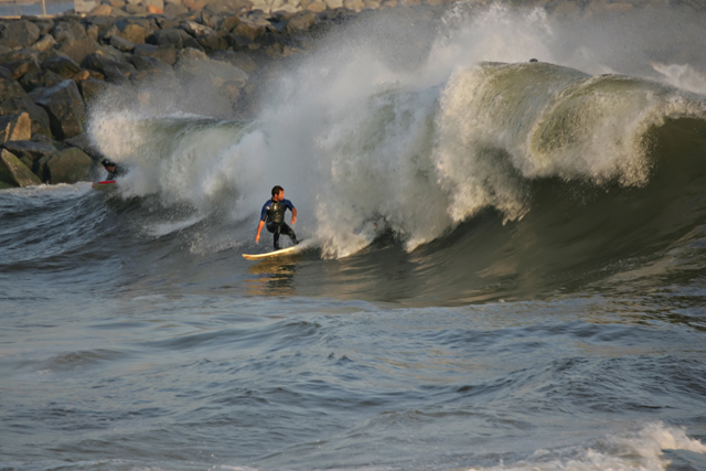
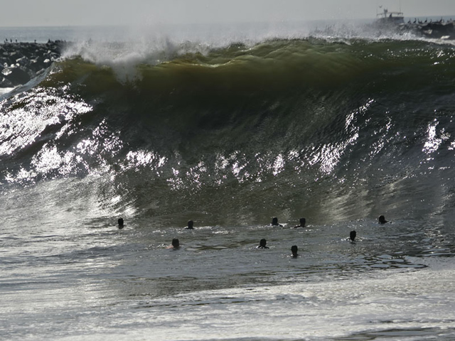
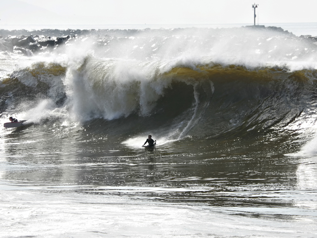
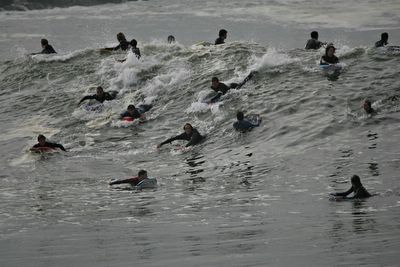
Wednesday, September 21, 2005

Antarctica - A Battle with Bergs


November 9, 2004. McMurdo Sound. Posted by Picasa

The USA under Bush has a need for technology established for Third World Nations

SATELLITES USED TO HELP PREDICT DEADLY DISEASE OUTBREAKS

NASA is providing new insights from space that may help health officials predict outbreaks of deadly water-borne cholera, a bacterial infection of the small intestine that can be fatal to humans.

Scientists have learned how to use satellites to track blooms of tiny floating plant and animal plankton that carry cholera bacteria by using satellite data on ocean temperatures, sea height and other climate variables. The work is described in a recent paper co-authored by University of Maryland Biotechnology Institute (UMBI) and NASA researchers that appeared in the Proceedings of the National Academy of Sciences.

"These experiments fulfill our hypothesis that cholera is associated with environmental conditions," said Dr. Rita Colwell, founder and former president of UMBI, and now Director of the National Science Foundation. She is presently on leave of absence from the University of Maryland, and is co-author of the cholera- tracking project paper.

The authors found that rising sea temperatures and ocean height near the coast of Bangladesh in the Bay of Bengal from 1992 to 1995 often preceded sudden growth, or "blooms," of plankton and outbreaks of cholera. Similar application of risk analysis developed by NASA using satellite data has also been used in the study of diseases such as malaria, Lyme disease and Rift Valley fever.

The ARTICLE CONTINUES ....

Demystifying a Storm - I hate oppression. In the media increased commercial interruption is a passive FORCED oppression of relivant information.

There are several ways of identifying the intensity of a storm when it is a convection center (A Spinning Storm with 'an eye.')

On a local level when a storm is approaching it can be detected by a barometer. If a storm is across the nation it won't be possible to detect it's severity for friends and family by a barometer.

Storms are measured by wind speed and pressure in millibars. There are correlations between the two that classify the severity of storms.

Shall we:

One Knot = 1.15077945 miles

Google Calculator: http://www.google.com/help/features.html#calculator

Type of Storm .............Wind Speed in Knots....................................Pressure in Millibars

Tropical Depression ....Less than 34 ................................................ Not Measured

Tropical Storm .............34 to 63 knots ..............................................Not Measured

Hurricane Cat One ......64 to 82 knots ..............................................Greater than 980 millibars

Hurricane Cat Two .....83 to 95 knots ..............................................965 to 980 millibars

Hurricane Cat Three ..96 to 112 knots ............................................945 to 964 millibars

Hurricane Cat Four ....113 to 135 knots ..........................................920 to 944 millibars

Hurricane Cat Five .....Greater than 135 knots...............................Less than 920 millibars

Yes, the speed of a storm is inverse to the it's pressure. The lower the pressure the more dangerous the storm.

The issue of proportion of commercials to 'subject' time on the USA airways is limiting the CONTENT of the news networks. Filling the airways with more and more commercials increases the PROPAGANDA of the government and industry and less information about the world and its interactions with the USA. This is an administration struggling AGAIN for control of it's image while fighting wars abroad and at home. A broad against the sovereign nations it has invaded, ie: I sight the British aggression against a Basra jail and in Afghanistan the wish of President Karzi for the foreign forces to leave his country. Domestically Bush is desperately fighting a war AGAINST Global Warming with the repeated storms in the Altantic and Gulf. He has gotten so desperate to maintain his oil focus that The National Hurricane Center is making up phenomina that it's director is stating is a cyclical dedade or two natural event.

If that were the case this would be 'old hat' and not alarming events. The USA lies chronically about environmental issues increasing the danger to citizens. I am used to this under this administration. When the manifestations of end stage Global Warming first manifested in October 2002 the National Weather Center came up with all kinds of phenomina but never the actual issue.

http://www.earthrescue911.org/er_founder_statement.pdf

I've been through this idiocy before.

Bill Clinton's new Global Initiative has the right idea. If Global Warming was insignificant it would be irrelivant. Global Warming is an issue globally that causes suffering and death.

Tuesday, September 20, 2005


September 20, 2005. Waiting out "Rita" in Miami. Posted by Picasa

September 20, 2005. This evening at Alton Road at Miami Beach, Florida and "Rita" Posted by Picasa

September 20, 2005. Miami and Rita. Posted by Picasa

September 20, 2005. The incoming feeder bands from "Rita" is flooding roads in Miami. Posted by Picasa

September 20, 2005. The turbulence of the Western and Northern Hemisphere west of North America. Posted by Picasa

September 20, 2005. Enhanced Infrared GOES WEST revealing the 'edge' of Rita and the four significant convection systems in the Pacific. Posted by Picasa

September 16, 2005.

High tide at Newport Beach, California is higher than normal this week.

Photographer states :: The end of a long and fun day. The high tide came in shortly after this last photo was taken, making for a really big end to the day! This series is from the Southern Hemi swell that hit SoCal this weekend 9-16/9-17. The sets seen here at the "Wedge" in Newport Beach were exceptionally high with some rogue waves hitting as high as 20-22' high. The swell is starting to fade but should last through tomorrow evening. Posted by Picasa

September 16, 2005.

Newport Beach, California.

Photographer states :: This wave crested at around 12 feet on Friday. This series is from the Southern Hemi swell that hit SoCal this weekend 9-16/9-17. The sets seen here at the "Wedge" in Newport Beach were exceptionally high with some rogue waves hitting as high as 20-22' high. The swell is starting to fade but should last through tomorrow evening. Posted by Picasa

September 16, 2005.

Newport Beach, California.

Photographer states :: This wave crested at around 13-15 feet on Friday. The evening sets of waves were really choppy due to the winds and we saw more than a share of splash in excess of 30 feet! Many cameras were ruined even on the beach due to the waves breaking near the crowds. This series is from the Southern Hemi swell that hit SoCal this weekend 9-16/9-17. The sets seen here at the "Wedge" in Newport Beach were exceptionally high with some rogue waves hitting as high as 20-22' high. The swell is starting to fade but should last through tomorrow evening. Posted by Picasa

September 16, 2005.

Newport Beach, California.

This phenomena is called "The Southern Hemi" by the surfers that dare take on "The Wedge." Posted by Picasa

September 16, 2005.

Newport Beach, California at 'The Wedge." These waves are 20 to 22 feet high. Yes, the storms in the Pacific are contributing to this. "The Wedge" is famous for near shore 'rouge' waves. The sea wall in the background is what causes all this turbulence as the ocean slams into it and reverberates off it to meet new incoming waves. Posted by Picasa

September 20, 2005. It is difficult to believe Hawaii isn't going to get hit by one of the major storms currently in the Pacific. "Jova" is a Cat 3 and currently will deliver winds and waves but it is "Kenneth" as the Cat 4 that might deliver an eye to Hawaii. There is a new convection system off Central America on the Pacific side. It is huge. It is a compliment to Rita no different than Hilary was to Katrina. The current 'jump' that occurred with Rita happened when it came closer to the vortex flow over central North America which turned south to meet "Rita" adding fuel to it's velocity. Posted by Picasa

September 19, 2005. "Rita" approaches over Zyphyr Hills, Florida. Posted by Picasa

September 20, 2005. 10th Street at South Beach, Florida lost a lifeguard station to a storm surge. Noted beach erosion is severe. Posted by Picasa

The Rooster Posted by Picasa

September 19, 2005. Sunlight through the clouds produced a unique image of the Severn Bridge in England.  Posted by Picasa

September 20, 2005. One Man's Quest. A Nation's Gratitude. Posted by Picasa