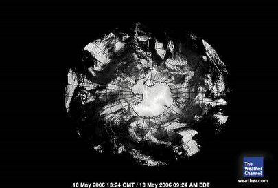
May 18, 2006. 1324 gmt.
If one looks through the entries on this blog, which are many and time consuming, one might notice the 'connectedness' of the aire masses between the equator and Antarctica.
This satellite provides a great deal of hope that that connectedness is breaking up. There are 'spaces/breaks' in the cloud masses. That in and of itself is not necessarily dictating a complete separation of 'hot and cold' aire masses but certainly dictates the separation of condensating and moisture holding aire masses. It is the 'moisture' holding clouds/storms that carry with it 'heat' accumulated at the equator and carried elsewhere. Clouds are 'condensation' and transition stages of gas to liquid resulting in rain. How many times will a rain feel warm on the skin or cold on the skin depending on the 'stage' of condensation of the rain and the origins of the storm/clouds.
So.
To realize the condensation aire masses are separating into hot and cold is very encouraging.
Currently the only aire masse that even and remotely comes close to heat transfer to Antarctica starts as 12 noon on the face of a clock superimposed over this satellite. That 'cloud' system meanders south BUT then travels away from the colder Antarctic Vortex and travels north again.
We remain vigilant.
