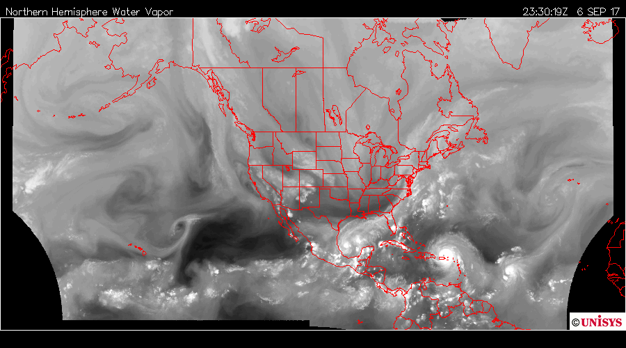
2330.10z
UNISYS Water Vapor Satellite of north and west hemisphere (click here for 12 hour loop - thank you)
My estimate has Hurricane Irma's eye landing over Cocoa Beach. That means nothing to Florida in that there will be torrential rain throughout the state of Florida.
I am going to stand by my estimate. Cocoa Beach and Melbourne. Closer to Cocoa Beach.
I am sure the coalition of computer programs will faithfully deliver the hurricane's major impact. Kennedy Space Center needs to batten down the hatches. The evacuations need to go forward.
The jet stream is prominent northwest of the water vapor feed from Katia to the North Atlantic. It has been pushing really cold air over the North American continent. It has been my experience in that the jet stream is unable to retain it's influences when vortexes exist. If I maintain that perspective, the path of Irma is more northwest than Northwest-west.
Irma is a very strong storm. The oscillation that exists with the other storms shows growing strength of both Jose and Katia. They are both category one storms right now. Irma has a lot of support in the troposphere. It is in the Atlantic and has all the water it wants.
There is a shadow storm in the Carribean Sea close to Katia. I thought it was dissipating and providing energy to Katia, but, that is not the case.
 September 7, 2017
0030.20z
UNISYS Water Vapor GOES East Satellite (click here for 12 hour loop - thank you)
This is the best satellite to view the shadow storm. It looks like a slightly grey spot south of Cuba. It is what Harvey looked like before it entered the Gulf. It is very faint, but, it is connected to Irma.
It is unclear what will occur with it. Right now it is a feeder system to Irma, however, as Irma moves northwest will this shadow storm move parallel and move into the Gulf as Katia dissipates?
That shadow storm is a strong entity. As Katia and Jose has obtained status of category one, the shadow storm oscillated, but, didn't dissipate. It is a structure. How it will resolve remains unknown to me. It might be the next named storm after Katia if it fills with water vapor as Harvey did. It is a complicated and dangerous troposphere. I don't want to hear anything different. This is a disastrous troposphere. It breaks my heart to hear the reports of the dead. The USA denied this problem and now people are dying. There is also a potential to another storm behind Jose. Oh, well.