2230.18z
UNISYS Enhanced Infrared USA southeast satellite image (click here)
There is debris noted in South Carolina. It is a very wide system so staying in shelter for a longer period of time may be prudent. Be aware in any underground shelter as to the flow of water. Do not leave the shelter unless absolutely necessary.
The storm may be moving toward North Carolina with potential tornadoes.
November 30, 2016
By AP
Atlanta -- A tornado touched down near Atlanta (click here) Wednesday as heavy storms continued to sweep through parts of the South.
The National Weather Service confirmed the tornado was located about seven miles north of Atlanta moving northeast about 40 mph around 1:50 p.m. Wednesday. A tornado warning was issued for counties including Fulton and DeKalb.
NWS meteoroligst Keith Stellman said there was some damage west of Atlanta near Six Flags Over Georgia. The weather service reported down power lines and multiple trees along with some roof damage.
A tornado watch was issued to more than 50 counties including Cobb and Gwinnett. It should expire at 6 p.m. Wednesday....

November 30, 2016
2230.19z
UNISYS Water Vapor GOES East Satellite (click here for 12 hour loop - thank you)
There is still water vapor diffusely connected to the system. There is a high pressure system over the islands. It is pushing the system northeast.
The small dotted area within that high pressure at the west side is beginning to connect to the system over the east coast USA. This isn't over yet. Those little dots are clouds.
The water vapor is filling in that high pressure system. The high pressure is being homogenized with the east coast system. It is turbulent.
November 30, 2016
609.17 PM EST
Intellicast USA satellite (click here for 2 hour loop - thank you)
This is a Intellicast December 3rd projection. The winds are significant over this area. (click here)
If this system is continually infused with water vapor there could be sustaining storms. The vortex is pulling the east coast 'TAIL' inward and not out to sea.
The jet is pushing the systems east with significant 50 mph winds. But, if the warm water vapor continues to fill in the part of the system moving east, this isn't over.
Local officials need to assess any flooding opposed to wind damage and damaged structures for future shelter.
November 30, 2016
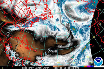
1623.15z
NOAA Satellite Image of GOES East water vapor satellite (click here)
The vortex over Lake Michigan is occurring because of a strong push back from the Europe system. If the Jet Stream can't move these air masses stagnation is possible with Coriolis.
In the UNISYS satellite the European system does not move at all. It is southeast of Greenland. The Jet Stream is moving the air masses below 30 degrees north where the Trade Winds live. The air masses are moving quickly over Africa. There is more stagnant air beginning with the Westerlies.
What does all that mean? Watchful waiting for potential danger. The chance of dangerous weather is significant and may remain so for a couple of days.
This is the way I see this issue with stagnating systems. The Earth has curves to the North Pole. The air column over these wind areas of Earth become lower as one moves to the North Pole. The troposphere is far more shallow over the North Pole than over the Northeast Trade Winds. That means warmer air expands. Those 'wind cells' of such as the Westerlies and the Trade Winds will maintain the same amount of air to some extent as it always has, but, in the year 2016 those air masses are far warmer and expand because of that warmer Earth. The expanded air mass will result in fronts that bump against each other and will stagnate and lose velocity.
Stagnation of air masses results in homogeneous temperatures and distribution of water vapor. Water vapor and heat equals danger.
This is the climate crisis. It is real. All too real. "Gee, I wish we listened to Henry Ford back in the day" when he warned society of the dangers of the greenhouse effect.
Know your reality. Survive the day.


