August 25, 2006.
0330z.
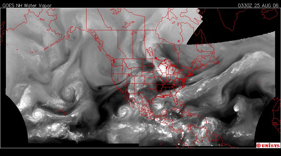
Water Vapor Satellite, hemispheric.
Easily discerned in this water vapor satellite is a system that links the Pacific hurricane off Mexico with the current turbulence over the Gulf of Mexico as well as offshore northeastern Florida.
It's Global Warming. It's immediate. It's unpredictable. It's violent. I don't hesitate these days to note danger regardless it's final dissipation. I don't want the people of the coastlines of these continents to ever face the danger they did last year unexpectedly.
I think there is an immediate concern for the Gulf of Mexico and it's coastal communities.
August 25, 2006
The Enhanced infrared shows a chain of energy which stretches from Africa to the Gulf, spanning to the Pacific and then engaging the Arctic Circle for heat transfer. This system is 'elastic.' I would like to note this burgeoning hurricane, now called 'Five' is exchanging heat with Africa and with the Gulf of Mexico. Realizing the turbulence with all these systems, it would be wrong to state the system had resolved it's dynamics to just one storm and that storm is completely predictable. These storms are not predictable. Their landfall remains unpredictable.
The Carribean has become a closed energy system all by itself as has the Gulf of Mexico. They do not mix with waters of the ocean as readily as the open Atlantic does and for that reason have become a potent fuel source for these storms due to the effects of Human Induced Global Warming.
I suspect 'Five' will take on a name and intensify, but, I also believe it can remain mostly a small annoyance while 'Six' takes shape as well. The angle of the sun and the carbon dioxide density of Earth avails itself to more intense scrutiny and not less.
