October 3, 2016
0430.21z
UNISYS Water Vapor Satellite of the north and west hemisphere (click here for 12 hour loop)
Interesting, the ITCZ (Intertropical Convergence Zone) is fully populated with water vapor. As a matter of fact isn't that Matthew that is also populating with the ITCZ?
Matthew has no resistance to populate it's system, hence obtaining velocity nearly effortlessly. It was moving at 25 miles per hour west, but, it stalled and then moved and stalled. It is in no hurry because it has found equilibrium as part of the ITCZ and is finding water vapor to fuel it's velocity.
What is the purpose to hurricanes? Today and decades past?
The purpose of any hurricane no matter how typical or atypical they are is to drive the heat of the troposphere into the oceans. Matthew is doing exactly that in large measure while sustaining water vapor content and growth within the ITCZ.
I don't think the National Weather Service has a name for a permanent hurricane. A resident, if you will.
Matthew has found its equilibrium and will continue it's physics with more heat than any hurricane before it. Matthew will move on and we'll all worry about whether it will finally move into the Gulf of Mexico or simply build to a Category Five in the Mediterranean without any real movement at all.
The direct sun light and the changing of it's location will have an effect on Matthew.
Interesting, isn't it?
By the way, the predictions haven't been right yet.
A Category 3 passing over Cuba. Right?
We'll see. Right now to me it looks as though the Yukatan will entertain the beast and let's hope Matthew doesn't find the heat in the Gulf inviting.
Good night.
Until later.
This Blog is created to stress the importance of Peace as an environmental directive. “I never give them hell. I just tell the truth and they think it’s hell.” – Harry Truman (I receive no compensation from any entry on this blog.)
Monday, October 03, 2016
Yes, Matthew is inhaling water vapor and without much expense of it's velocity.
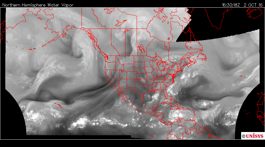
October 2, 2016
1630.18z
UNISYS Water Vapor Satellite of the north and west hemisphere
This is two hours after the last entry and image 2. Matthew is still changing the condition of the water vapor air mass from the east Pacific to the eastern shore of North America. The GOES East Satellite below relates the same story.
October 2, 2016
1630.18z
UNISYS Water Vapor Satellite of the north and west hemisphere.
But, now look at Matthew.
The two lobes still remain strong and stable, but, the bands are huge and wide and increasing in water vapor content. The trailing bands are now reaching back to the Lesser Antilles. The people of St. Lucia believed the worst was over after Matthew passed,but, now the bans are reaching them again and probably kicking up the sea again.
12 hours later it looks like this:
October 3, 2016
0430.21z
UNISYS Water Vapor of the GOES East satellite.
There appears to be a three lobed system. It is not only a three lobed system, it is tighter and better defined than 12 hours previous.
Matthew is becoming a stronger and stronger storm and is now a sustained Category 4 hurricane. AND. The central pressures are continuing to drop every two to three hours. Currently, Matthew is at 943 millibars of pressure. It was at 945 millibars for nine hours and previous to that it was 947 millibars for 6 hours and previous to that it was 940 millibars. What? 940? What?
I'll be darn Matthew sustained 940 millibars for over nine hours when it was a two lobed system.
So what gives with giant in the Caribbean?
Oscillation. The 'breathing' of the hurricane was consistent at 940 millibars, but, then it relaxed. It let it's periphery expand. Right? Soaking up more and more water vapor from the air mass system that was once believed going to direct Matthew north, but, it that isn't what happened. Matthew inhaled the water vapor and now is beginning to contract finding more and more velocity to lower it's central pressure once again.
I want to take a look at the hemispheric satellite now.
1630.18z
UNISYS Water Vapor Satellite of the north and west hemisphere
This is two hours after the last entry and image 2. Matthew is still changing the condition of the water vapor air mass from the east Pacific to the eastern shore of North America. The GOES East Satellite below relates the same story.
October 2, 2016
1630.18z
UNISYS Water Vapor Satellite of the north and west hemisphere.
But, now look at Matthew.
The two lobes still remain strong and stable, but, the bands are huge and wide and increasing in water vapor content. The trailing bands are now reaching back to the Lesser Antilles. The people of St. Lucia believed the worst was over after Matthew passed,but, now the bans are reaching them again and probably kicking up the sea again.
12 hours later it looks like this:
October 3, 20160430.21z
UNISYS Water Vapor of the GOES East satellite.
There appears to be a three lobed system. It is not only a three lobed system, it is tighter and better defined than 12 hours previous.
Matthew is becoming a stronger and stronger storm and is now a sustained Category 4 hurricane. AND. The central pressures are continuing to drop every two to three hours. Currently, Matthew is at 943 millibars of pressure. It was at 945 millibars for nine hours and previous to that it was 947 millibars for 6 hours and previous to that it was 940 millibars. What? 940? What?
I'll be darn Matthew sustained 940 millibars for over nine hours when it was a two lobed system.
So what gives with giant in the Caribbean?
Oscillation. The 'breathing' of the hurricane was consistent at 940 millibars, but, then it relaxed. It let it's periphery expand. Right? Soaking up more and more water vapor from the air mass system that was once believed going to direct Matthew north, but, it that isn't what happened. Matthew inhaled the water vapor and now is beginning to contract finding more and more velocity to lower it's central pressure once again.
I want to take a look at the hemispheric satellite now.
October 2, 20160230.19z
UNISYS Water Vapor Satellite of the north and west hemisphere
There is a very big difference between the two satellite pictures of Hurricane Matthew. The time span is 12 hours. The storm went from a diffuse storm that looks to be weakening in the first image, but, that isn't what happened.
Also to note is the strong water vapor link between the eastern shore of North America all the way down to Costa Rica and the eastern Pacific Ocean. There is lots and lots of water vapor throughout that air mass. If there is doubt, it is the air mass directly to the west of a weak appearing Matthew.
In the later satellite below Matthew is now a well formed hurricane with a defined eye AND it is a dual lobed system. There are also well defined bands coming of it. The diameter of the storm is still massive with lots and lots of water vapor.
What has happened to the water vapor trail from the eastern Pacific Ocean across Costa Rica. Wait a minute. That is Nicaragua and Honduras and El Salvador. It is Nicaragua, Honduras and El Salvador in the image above as well.
In the image of 1430, Matthew is imposing itself on that air mass and defining a margin/border. Basically, it appears as thought Matthew is pushing the air mass out of the way. Better put, Matthew is moving the air mass below it's massive size and absorbing it at the back radiating bands. Said differently, the water vapor of that system is being absorbed and building Matthew into a stronger storm.
October 2, 2016
1430.18z
UNISYS Water Vapor GOES East Satellite
Good Morning at 12:25 AM
Next on the agenda of the Kyoto Protocol is:
Industrial processes
Mineral products
Chemical industry
Metal production
Other production
Production of halocarbons and sulphur hexafluoride
Consumption of halocarbons and sulphur hexafluoride
Other
But, where to begin?
See, everyone thinks this is all negative and regulatory in nature and it isn't. President Obama being the "Wise Man" that he is began to change chemistry and the way it is viewed in the 21st Century.
President Obama cast aside all the nasty chemicals that were actually harmful to people and children and asked chemists to find a way for chemistry and people to live together. He wanted to have chemistry be useful without being harmful.
So, step by step, chemists began to look for solutions. Yes, solutions and it is not a play on words. The chemists set out to break open a new horizon in chemistry and appropriately enough it is called "Green Chemistry."
But, I think I will save that for later and tonight discuss Hurricane Matthew. I hope there is no objection.
Sunday, October 02, 2016
Did he personally sign that?
Congratulations on exceptional work and loyalty to the electorate. The part of the page that shows nearly a billion dollars of losses by the Trump Organization. Like. Ah. Wow.
October 1, 2016
By David Barstow, Susane Craig, Russ Buettner and Megan Twohey
...Tax experts hired by The Times (click here) to analyze Mr. Trump’s 1995 records said that tax rules especially advantageous to wealthy filers would have allowed Mr. Trump to use his $916 million loss to cancel out an equivalent amount of taxable income over an 18-year period....
Yeah, he signed.
In 1996 Donald Trump sold all his holdings in beauty pageants, except, Miss Universe.
It boggles the mind to realize this is 1995 and he lost nearly $1 billion US. If that level of loss were in 2016 it would be $1,446,840,209.84. The 1995 dollar is not $!.58. A billion and a half if the losses existed today.
The opulence knows no end. I sincerely doubt Donald Trump has ever paid taxes from 1995 going forward.
Trump Tower in Las Vegas. The exterior windows are gilded with 24-karat gold. The hotel is a member of The Leading Hotels of the World.Tower 1 opened on March 31, 2008, with 1,282 rooms.
By David Barstow, Susane Craig, Russ Buettner and Megan Twohey
...Tax experts hired by The Times (click here) to analyze Mr. Trump’s 1995 records said that tax rules especially advantageous to wealthy filers would have allowed Mr. Trump to use his $916 million loss to cancel out an equivalent amount of taxable income over an 18-year period....
Yeah, he signed.
In 1996 Donald Trump sold all his holdings in beauty pageants, except, Miss Universe.
It boggles the mind to realize this is 1995 and he lost nearly $1 billion US. If that level of loss were in 2016 it would be $1,446,840,209.84. The 1995 dollar is not $!.58. A billion and a half if the losses existed today.
Saturday, October 01, 2016
I think the government is finally seeing the criminality in banking. Wells Fargo could be held for racketeering.
September 29, 2016
It is unlawful for anyone employed by or associated with any enterprise engaged in, or the activities of which affect, interstate or foreign commerce, to conduct or participate, directly or indirectly, in the conduct of such enterprise's affairs through a pattern of racketeering activity or collection of unlawful debt....
By Ben Lane
Throughout Wells Fargo CEO John Stumpf’s (click here) rough day in front of the House Financial Services Committee, multiple representatives called for the bank to be broken up, suggesting that the megabank is simply too big to manage effectively.
But as the five-hour hearing neared its conclusion, the ranking member of the committee, Rep. Maxine Waters, D-Calif., went beyond her fellow representatives’ calls to break up Wells Fargo, stating that she is going to actually move to break up the bank.
“I’ve come to the conclusion that Wells Fargo should be broken up,” Waters said. "It’s too big to manage and I’m moving forward to break up the bank.”
According to a represenative from Waters' office, Waters told reporters after the hearing that she plans to pursue legislation to break up the bank.
Waters' declaration that action will be taken to break up the bank goes beyond what other representatives said during Stumpf’s appearance.
“This bank is too big to manage and it’s time to break them up,” Rep. Brad Sherman, D-Calif., said earlier in the hearing....
Realize there is no governance in these banks. We have seen the London Whale, too. There have been time and again financial institutions, many trusted in the past, becoming ungovernable. The tragedy seems contrived to many Americans who have become used to "The Coping American" rather than the outraged American.
Americans have become used to the Bush paradigm of government whereby if the government kills the company the people will suffer for the loss of monies due them. Americans have become used to the idea all is fair until it is not and course correction has to take place. The same apathy is exampled in Wells Fargo Banks SCHEME. There were a lot of people involved in this scheme and the CEO simply sat back and reaped bonuses from the increasing bottom line. Where was the incentive to find out where the money was coming from and congratulate the executive who initiated a powerful tool to bring in customers?
US Representative Maxine Waters is correct. This is dangerous. When is Wells Fargo Bank going to collapse because it no longer has a sustainable business model and all those false accounts result in a balance sheet of Zero of NEGATIVE balance.
This is just another bank behaving badly, this is a very destructive spiral into failure. Wells Fargo may be able to absorb the losses, but, what kind of programs were other banks developing and using to compete with this wayward bank? Wells Fargo didn't just misbehave, it compromised the financial markets yet again. It is time to begin to bring Wells Fargo down in size to allow a bank that can be governed without exploitation of fantasy.
This is fraud. The fraud was systemic and hopefully it has not effected the entire financial system. Where is AIG when you need them?
It is unlawful for anyone employed by or associated with any enterprise engaged in, or the activities of which affect, interstate or foreign commerce, to conduct or participate, directly or indirectly, in the conduct of such enterprise's affairs through a pattern of racketeering activity or collection of unlawful debt....
Friday, September 30, 2016
The Flint River Water Project
Ongoing Research:
This project requires dates and times. I have to learn the dates and times from the research material and then enter it to retrieve the information I am looking for. In addition to that there is the variety of locations the information can be. That is not an issue. I can obtain data as I go and record it as I read it. That means I can have multiple points of fact that I read and record in a chronological dialogue. It is just tedious. This is going to take awhile, but, it won't take forever.
Did you know Flint, Michigan is at a 90 degree elbow turn in the Flint River?
There is such a thing as river processes that bring about changes in the river flow. I find it more than interesting such a "right angle (90 degrees)" exists at the place the city is named the same as the river. People name things, including rivers.
The pressure of water breaks (click here) away rock particles from the river bed and banks. The force of the water hits river banks, and then pushes water into cracks. Air becomes compressed, pressure increases and the riverbank may, in time collapse. Where velocity is high e.g. the outer bend of meaner, hydraulic action can remove material from the banks which may lead to undercutting and and river bank collapse. Near waterfalls and and rapids, the force may be strong enough to work on lines of weakness in joints and bedding planes until they are eroded.
There is something else I find interesting.
Below is the legend for the entire map of the USA.
Michigan falls into the next to lowest number of EPA water samples with other states, other than zero.

This is not by far all the information I am looking for, but, I want everyone to know I am sincere about coming to terms with the atrocity that occurred under Governor Snyder.
Alaska, known for it's beautiful rivers full of fish, falls into the category of 335,421 to 879,332 discrete water samples according to the color of the legend. It is estimated Michigan's population in 2014 is 9.9 million people, while Alaska's population is 736,732 in the same year.
The point is I don't want to hear excuses that northern Michigan doesn't need that much vigilance. If Alaska requires that level of vigilance, so does Michigan.
According to the drop down menu, Alaska has 1,447,049 EPA discrete water samples with an additional 53,823 USGS discrete water samples.
There is something wrong with this picture. The fisheries are commercial and people's lives are not. That is just me and not official record that I have located yet.
Thank you for your interest.
Bags of "Children Sand" come in bags full of clean sand.
This is an old advertisement. But, most home improvement stores carry it.
We now have 25 pound bags (click here) of play sand from the Oregon coast available for sale in Portland! Yeah! No amount too small or too large, we can always get more.
This is premium sand. It’s not that awful dusty, pebble filled STUFF they sell at home improvement stores (and toy stores sadly). It is HONEST TO GOODNESS real sand, like you would find at the beach on the ocean, but since it is from the dunes, it doesn’t have the salt in it like beach sand.
If you want your kids to have a great time and not inhale a bunch of dirty dust while playing in the sandbox, please call us and buy our sand!
It works! It is clean. No critters. Safe to put in the house inside doors. Don't use if sand is spilling out.
DO NOT BARRICADE AN EXIT FROM THE HOUSE OR GARAGE OR WHATEVER SHELTER IS USED IN A STORM.
If the water is getting so high a lower horizon of sand bags is not containing the water, then get out of the building and go to a shelter or higher ground where help can be found.
DO NOT BARRICADE AN EXIT FROM THE HOUSE OR GARAGE OR WHATEVER SHELTER IS USED IN A STORM.
If the water is getting so high a lower horizon of sand bags is not containing the water, then get out of the building and go to a shelter or higher ground where help can be found.
Everyone keeps some sandbags handy outside the door and around the side of the house, right?
September 30, 2016
1230.18z
UNISYS north and east hemispheric water vapor satellite (click here for 12 hour loop)
The next phenomena is noted west of Alaska.

There is a very large vortex, but, it is more than a vortex. There is a hemisphere roll cloud from my assessment. Roll clouds are sometimes stated to be alien invasions, but, they aren't at all.
Roll clouds and shelf clouds fall into the same category, arcus clouds. Roll clouds form because of an outflow of cold air. It makes sense this extra large phenomena would manifest out of Arctic air coming down from the Arctic circle. There is more than sufficient cold air for this to manifest. It is not over Alaska, but, over the Bering Sea and the north Pacific.

To have a hemispheric roll cloud is strange, but, to have one feed by dense water vapor is more than curious (dense white area).
To the left is radar of the phenomena via Accuweather radar (click here)
This is an extremely rare phenomena, but, I have seen it once before in far less dynamics in 2016.
September 30, 2016
1630.18z
UNISYS west and north hemisphere water vapor satellite (click here for 12 hour loop)
Not to ignore the small phenomena. The east Pacific storms rolling over the continent to build into storms has a diminished amount of water vapor to produce those storms. So, while Matthew is growing and moving the tropical storms may abate for a day or so.
There is also a circulation center developing directly west and off shore of Oregon and Washington state. It is feeding off the water vapor that is also a part of the roll cloud 'system.'
This vortex is nearly the same latitude of the land-based hurricane over Lake Michigan that is now migrating northwest.
There are two offshore circulation centers off the east coast, east of New Jersey and east of the Bahamas. These circulation centers are being somewhat deprived of water vapor by the land based hurricane/tropical storm over Lake Michigan. These offshore systems most probably will not effect land, but, are in oscillation with the Lake Michigan Tropical Storm (hurricane).
Hurricane Matthew is a huge storm. It is so WET with water vapor it has a trail behind it reaching back to the ITCZ. It is that reach full of fuel (water vapor) that concerns me of Matthew's potential. This hurricane is already a Cat Two storm and growing. The central pressures are dropping like a rock and the potential for a very high velocity storm exists due to it's rich water vapor content.
There are multiple phenomena with the air masses over North America today.
September 30, 2016
1230.18z
UNISYS north and east hemispheric water vapor satellite (click here for 12 hour loop)
It took only nine hours as a category one for Hurricane Matthew to become a category two. The storm is now moving at about 25 miles per hour. This is a very fast storm both in the movement west and it's acceleration of velocity.
There is also much to note on the current air masses on this image. There is a solitary land based hurricane over Lake Michigan. It developed over land and is now an independent circulation system.
September 30, 2016
1230.18z
UNISYS modified water vapor satellite of midwest (central North America). (click here forenhanced infrared 12 hour loop)
Since 2006 there have been hurricanes that developed 'near shore.' It only makes sense as the heat increases in the troposphere that ability of Earth to turn water vapor into a hurricane would begin to translate over the Great Lakes.
September 28, 2016
By Richard Ray
At least eight water spouts (click here) formed over Lake Michigan near the Chicago area on Wednesday, the National Weather Service confirmed.
Water spouts formed as early as 8:30 a.m. near the city’s Lincoln Park neighborhood and Navy Pier and continued to form and dissipate into the afternoon, as late as about 3:30 pm...
[Storm where I am (34.2085° N, 77.7964° W) contained rain dense enough to turn the air white with rolling thunder and sharp lightning outside the window. The duration of the storm was approximately five minutes, but, can still be heard in the distance. Rain continued and air appears normal.]
There is some flooding in the house. I'll continue the entry in separate window and clean up this entry a little latter.
1230.18z
UNISYS north and east hemispheric water vapor satellite (click here for 12 hour loop)
It took only nine hours as a category one for Hurricane Matthew to become a category two. The storm is now moving at about 25 miles per hour. This is a very fast storm both in the movement west and it's acceleration of velocity.
There is also much to note on the current air masses on this image. There is a solitary land based hurricane over Lake Michigan. It developed over land and is now an independent circulation system.
September 30, 2016
1230.18z
UNISYS modified water vapor satellite of midwest (central North America). (click here forenhanced infrared 12 hour loop)
Since 2006 there have been hurricanes that developed 'near shore.' It only makes sense as the heat increases in the troposphere that ability of Earth to turn water vapor into a hurricane would begin to translate over the Great Lakes.
September 28, 2016
By Richard Ray
At least eight water spouts (click here) formed over Lake Michigan near the Chicago area on Wednesday, the National Weather Service confirmed.
Water spouts formed as early as 8:30 a.m. near the city’s Lincoln Park neighborhood and Navy Pier and continued to form and dissipate into the afternoon, as late as about 3:30 pm...
[Storm where I am (34.2085° N, 77.7964° W) contained rain dense enough to turn the air white with rolling thunder and sharp lightning outside the window. The duration of the storm was approximately five minutes, but, can still be heard in the distance. Rain continued and air appears normal.]
There is some flooding in the house. I'll continue the entry in separate window and clean up this entry a little latter.
Subscribe to:
Posts (Atom)