Monday, May 14, 2007

Hundreds of Birds Falling from the Skies Above Florida


One of hundreds of birds that have fallen out of the sky after being disoriented by the smoke from Florida wildfires. (ABC News)
Posted by Picasa
By PATRICIA MARTELL
May 13, 2007
As if the massive wildfires raging across Florida weren't enough for residents to worry about, many are now looking to the skies, and facing another problem.
The clouds of smoke produced by the fire are causing hundreds of birds in Broward and Miami-Dade counties to drop out of the sky or crash into the windows of buildings. Wildlife officials say hundreds of yellow warblers have died.
"The smoke disorients the birds and impairs their vision," said Stefan Harsch of the Wildlife Care Center in Ft. Lauderdale. Harsch says he has been treating more birds than people.
"The birds are coming in with concussions," he said. "We treat them with painkillers and anti-inflammatory drugs like an ibuprofen."
"This is out of control," said Wendy Fox, executive director of Miami's Pelican Harbor Seabird Station. "There are hundreds of them."
The Wildlife Care Center says that many of the injured birds will recover from their injuries if they are treated. They recommend that people bring injured warblers to their local vet or pick up injured birds and put them in a safe place like a box with breathing holes.
"They're vulnerable if they stay outside," said Harsch. "Sometimes being in a safe place is enough."

Winds expected to fan Ga.-Fla. fires

Posted by Picasa
May 11, 2007
Orlando, Florida
Photographer states :: Smoke From the Wildfires in Floirda
LAKE CITY — Hope in the form of rain turned into fear that stronger winds were on the way early today as firefighters faced another hard day battling a massive wildfire along the Georgia-Florida line.The wildfire that raced through the Okefenokee Swamp in southeast Georgia and into Florida was started by lightning more than a week ago. By early today, it had burned 102,500 acres in Florida and was 30 percent contained.Winds in the area of the Florida fires were expected to be 15 mph with gusts up to 25 mph today. That was up from winds of 6-8 mph, said U.S. Forest Service spokeswoman Nina Barrow. Scattered rain showers hit the area of the fire on Sunday, but the extent of the rain's effect was not clear....

12 hour loop


May 14, 2007
1730z
Water Vapor GOES East by UNISYS

That water vapor 'trail' over Louisiana, the Gulf, Florida and out to the Atlantic just doesn't leave, does it? Noted increased water vapor west of the Great Lakes just north of the Canadian/American border. Not easily noted in this view, a Pacific vortex at a favorite location south of Alaska. Interesting intensity of water vapor south of Cuba as well.
Posted by Picasa

Recent article from NASA - January 3, 2007

Posted by Picasa
Townshend had just returned from NASA Goddard Space Flight Center in Greenbelt, Maryland, where remote-sensing ecologist Compton Tucker had developed a new scale, or index, of global vegetation based on satellite data. Made from data collected by the Advanced Very High Resolution Radiometer sensors flying on a series of NOAA meteorological satellites, the index could show how much photosynthesis was happening in every 8-by-8-kilometer patch of ground. Displayed as a map, the index revealed the productivity of the grazing land over a broad area over successive 15-day periods. Townshend showed Prince a print-out of the vegetation index of Africa. “It blew me away that we could see a complete continent at frequent time intervals,” Prince says. “It was a career-changing moment.” Realizing the vegetation index’s potential, Prince moved to Goddard Space Flight Center to join Tucker and others in studying the world’s vegetation from space. Today, he is a Professor in the Geography Department at the University of Maryland, College Park.

Compares nearly exactly with the humidity noted below. Africa does something right. They are people that love their land, their traditions within the land. Incredible people. Got to have humidity to have rain. Got to have humidity to cool Earth. Can't do it without it.

May 14, 2007
1523 gmt
Africa - Europe Satellite


Lots of humidity over Africa. Hm. Wondering. Drought conditions exist, but, I don't recall anyone reporting the jungles drying up. Hm. We might see the start of a hurricane or two off West Africa this season, but, the humidity is a little more south than 'normal.'
Posted by Picasa
There is significant discussion on the net about Brazil's Amazon and drought-like conditions, the relationship between the Amazon and African Dust Storms, which also spawn algal blooms.
But, little discussion about Africa's jungles and their viable health. Odd.

May 14, 2007
1527 gmt
Western Hemisphere


Very 'weird' air pattern over southern South America - Chile - Argentina and into near coastal Southern Antarctica.
Some activity in Western Africa with June 1st approaching for the 'official' Atlantic Hurricane season starting.
Central North America is experiencing more storms as noted yesterday. Some are severe.
Last week's turbulent weather is now over the North Atlantic and not doubt moving to the Arctic Circle.
The equatorial air is everywhere. It has no clear 'zero' degree latitude in this hemisphere. There isn't enough humidity to support the equatorial air mass without it wandering hither and nill.
Posted by Picasa

May 14, 2007
1707 gmt
Western Pacific Satellite.

Lots and lots of heat. It's distributing into both north and south hemispheres. My estimation at this point is that 'significant amounts of humidity' is here and that is the PRIMARY area of Earth that can supply water vapor to the heat transfer systems. I sincerely believe this phenomena, which is new this year, will sustain through at least autumn and quite possibly winter. Noted in the center of the satellite picture, a vortex with circular formation. Hm. There was a typhoon recently just west of that location : Typhoon KONG_REY (click here) Possibly some remaining heat and turbulence that is reorganizing/dissipating. It won't be heading to Antarctica at any rate.
Posted by Picasa

May 14, 2007
1534 gmt
Pacific Global Satellite


There it is the WAIS vortex as 6 o'clock in this satellite. The vortices are coming off the equator. This one is from the Western Pacific Islands again. It seems no matter how much the sunlight proceeds north this is a chronic event now in the Southern Hemisphere.
Posted by Picasa

May 14, 2007
1307 gmt
Southern hemisphere
.

Noted at 5 o'clock a vortex landing in East Antarctica. Should cause some increased temperatures noted by tomorrow or late tonight. There is also another at 9 o'clock approaching WAIS.
Posted by Picasa
Posted by Picasa
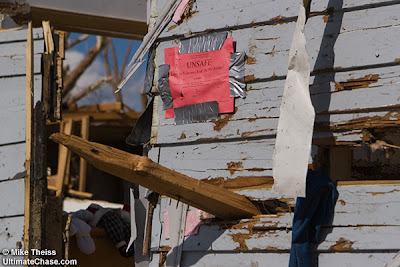
Photographer states :: Photo of a 2x4 impaled into the side of a house after an EF-5 tornado struck Greensburg, Kasas.

Some of Mike's pictures are heartbreaking.

Posted by Picasa
Photographer states :: Photo of a sign lying in tornado debris that says "I Love You Mom".

Greensburg, Kansas - The grain elevator is still standing. At least that landmark is a reference point.

Posted by Picasa
May 10, 2007
Photographer states :: Photos of a destroyed home with one small room still standing.

Penguin Cam Today. Lots more snow and darkness along with autumn and winter approaching.

Posted by Picasa

24 hour loop. The warmest time of day is 6PM and 12 PM and 3 PM are missing.


Monday, May 14, 2007
9:00 AM
Antarctica


The overall continent is below zero but the peninsula is a lot warmer. It started that marginal movement last week with all those vortices landing over WAIS.


The warmest place is on the Peninsula:


Palmer Station, Antarctica (8AM CLT)
Elevation :: 26 ft / 8 m
Temperature :: 37 °F / 3 °C
Conditons :: Light Rain
Humidity :: 73%
Dew Point :: 31 °F / 0 °C
Wind :: 4 mph / 7 km/h / from the SE

Wind Gust :: -
Pressure :: 29.21 in / 989 hPa (Rising)
Visibility :: 10.0 miles / 16.0 kilometers

Aviation
Flight Rule :: VFR ()
Wind Speed :: 4 mph / 7 km/h /
Wind Dir :: 130° (SE)
Ceiling :: 100000 ft / 100000 m


The coldest place in Antarctica (No Surprise here - the above 10,000 feet elevation - Top of the Blue Ice, youuuuu guessed it....)


Vostok, Antarctica (6PM Vost)
Elevation :: 11220 ft / 3420 m
Temperature :: -84 °F / -64 °C
Humidity :: 64%
Dew Point :: -87 °F / -66 °C
Wind :: 9 mph / 15 km/h / from the SSW
Conditions not stated
Wind Gust :: -
Pressure :: in / hPa (Rising)
Visibility :: 12.0 miles / 20.0 kilometers

Aviation
Flight Rule :: VFR ()
Wind Speed :: 9 mph / 15 km/h /
Wind Dir :: 200° (SSW)
Ceiling :: 100000 ft / 100000 m

Posted by Picasa

Current Scott Base Webcam Picture

Posted by Picasa
Well done, Scott Base.

The weather at Scott Base, Ross Island, Antarctica (Crystal Ice Chime) is freezing :

Posted by Picasa
Posted by Picasa
May 12, 2007
Girdwood, Alaska
Photographer states :: Here is the view of turnagain arm from the top of Mount Aleyeska. In the distance you can see the Chugach mountains, Kenai Penninsula, and the sun shining on the sea.

The weather at Glacier Bay National Park (Crystal Wind Chime) is:

Elevation :: 33 feet

Temperature :: 45 F/ 7 C

Conditions :: Overcast

Humidity :: 76%

Dew Point :: 37F / 3C

Wind :: 6mph / 9 km/h / 2.6 m/s from the NW

Pressure :: 30.35 inches / 1028 hPa (Steady)

Windchill :: 41 F / 5 C

Visibility :: 10.0 miles / 16.1 kilometers

UV :: 1 out of 16

Clouds :: Overcast 3200 feet / 975 meteres
(Above the ground)