Antarctica Wind Chime
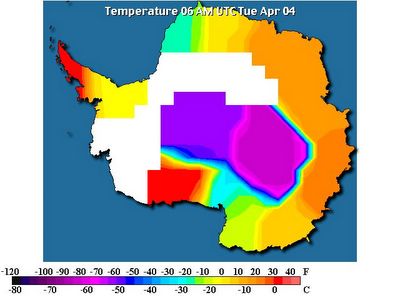 April 4, 2006. Antartica at 6:00 am. The heat is directly next to the Big Blue Ice over WAIS (West Antarctica Ice Sheet). In some of the animation it is noted the heat is traversing across the 3 mile high icesheet.
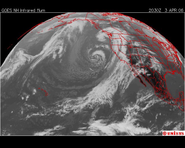
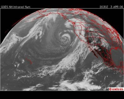 April 3, 2006. 2030z. Infrared statellite. It's far scarier in water vapor resolution.
New Storm Moves Into Southland
Rain and winds are expected to batter the region, raising concern about floods, mudslides.
By J. Michael Kennedy, Times Staff Writer
April 4, 2006
A storm dipping south from the Gulf of Alaska is expected to bring Southern California three days of rain — some of it in heavy downpours — with the possibility of mudslides in recently burned areas.
But while the arrival of this latest storm was cause for concern in Southern California, the situation was more pressing in the northern part of the state, where much of the region remained under a flood alert. A month of nearly continuous rainfall has endangered the stability of levees and raised rivers to flood levels.
The Los Angeles-area rain was expected to increase from intermittent showers to steady rainfall early today and continue through Wednesday. The heaviest rainfall was expected in the San Gabriel Valley, where 5 or more inches could fall, said Bonnie Bartling, a specialist with the National Weather Service.
The storm system should drop 1 to 3 inches of rain along the coast and more than 3 inches in the mountains and foothills.
The storm should continue through Wednesday, with the heaviest precipitation probably coming today, Bartling said. She said there could be 4 to 7 inches of snow in the upper mountains today and in lower elevations overnight as the air cools.
Accumulations of up to 7 inches are expected at the 5,000-foot level by Wednesday morning. Winds between 20 and 30 mph are expected in the next two days.
Despite the expected rain, Laurel Canyon Boulevard in the Hollywood Hills was reopened Monday after being closed over the weekend when a rain-drenched hillside began to slide.
Crews installed concrete barriers Sunday to protect against mud and debris flows that could be brought on by rain.
Bartling said other areas of concern would include the areas of last year's Topanga, Foothill and Harvard fires. Because the burn areas lack ground cover, they are more prone to breaking up and becoming mudslides when soaked.
Sam Padilla, a spokesman for the Los Angeles County Fire Department, said all stations near the burn areas are equipped with sandbags if residents need them.
"They are keeping their eye on areas where the vegetation has been depleted and the ground is most vulnerable," he said.
Meanwhile, continuing deluges in Northern California kept roads closed and raised concerns about flooding and mudslides there. Major Northern California reservoirs were increasing releases in anticipation of runoff from mountain snowmelt as skies dump more rain on the saturated region.
The National Weather Service in Monterey said there appeared to be little chance of a return to dry weather for the foreseeable future. The state Department of Water Resources issued a flood alert, formally raising the agency's emergency level.
The Bay Area has endured record-breaking wet weather over the last month. San Francisco had 25 days of rain in March, breaking the previous record of 23 days set in 1904. Oakland, San Rafael and Santa Rosa also broke rainy-day records in March.
Late Sunday, the California Highway Patrol closed a section of Highway 1 between Pacifica and Montara after a portion dipped about a foot in the northbound lane, south of Pacifica.
http://www.latimes.com/news/printedition/california/la-me-rain4apr04,1,7877320.story?coll=la-headlines-pe-california
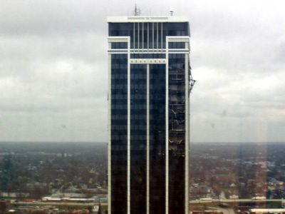 This picture was taken by a citizen of Indianapolice from another nearby tower this is the Region Bank. All this damage was caused by high wind according to this photographer. The structure has physical damage on at least two sides. Very costly. I guess Global Warming was supposed to make itself known in a Hollywood style way to impress the people of this country. Not necessarily. But, a heck of a storm system moved in from the west yesterday."Day After Tomorrow" is here !Rich Van Wyk/Eyewitness NewsIndianapolis, April 3 - A severe storm blew gaping holes through Indiana's third tallest building Sunday night.Corner offices were left wide open after windows and walls were peeled away. However, desks, chairs and other furnishings went untouched.For downtown workers this is a sight of stunning fascination."it is amazing. It is amazing what mother nature has don to the building," said John Pappas.
Sixteen of the tower's 36 floors are damaged. Yet it's owner says the building is structurally sound."City engineers have gone through, they've walked every floor of the building to make sure it is safe," said Todd Maurer, president of Halakar Properties.The building, best known as the Region's Bank Tower is closed until workers seal off damaged areas. It's a major inconvenience for dozens of legal, financial and professional firms located here. With two weeks left until tax day, Ted Mesh's CPA firm hasn't a day to loose."We need to get back to work. Whether it is from there or another location or work from home," said Ted Mesh of RJ CPA.Tons of debris rained down on several blocks over night. Some of it knocked holes through the roof of the Indianapolis Star.Even more steel and glass appear ready to fly off in the stiff winds. Streets are blocked to cars and pedestrians, jamming traffic in all directions."When we are sure nothing is going to fall off the buildings, then we will reopen the streets," explained Mayor Bart Peterson.
The weather at Glacier Bay National Park (Crystal Wind Chime) is:
36 °F / 2 °C
Overcast
Humidity:
70%
Dew Point:
27 °F / -3 °C
Wind:
Calm North
Pressure:
30.01 in / 1016 hPa
Visibility:
10.0 miles / 16.1 kilometers
UV:
0 out of 16
Clouds:
Mostly Cloudy 3600 ft / 1097 m
Overcast 4300 ft / 1310 m
(Above Ground
The weather in Antarctica (Crystal Ice Chime) is:
Scott Base
-26.0°
Updated Tuesday 04 Apr 8:30PMend