January 29, 2008
1730z
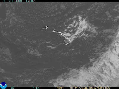
Hawaii Satellite
There is also an accumulating vortex building in the area of Hawaii.
COASTAL HAZARD MESSAGE (click here)
NATIONAL WEATHER SERVICE HONOLULU HI
758 AM HST TUE JAN 29 2008
...HIGH SURF ADVISORY FOR EAST FACING SHORES OF ALL ISLANDS...
...HIGH SURF ADVISORY FOR NORTH FACING SHORES IS CANCELLED...
.OVERVIEW...FRESH TRADE WINDS BLOWING ACROSS THE CENTRAL PACIFIC WILLCONTINUE TO PRODUCE ROUGH AND LARGE SURF ABOVE ADVISORY LEVELS ALONGEAST FACING SHORES. THE NORTHWEST SWELL AFFECTING THE ISLANDS ISSMALLER THAN ANTICIPATED...AND SURF ALONG NORTH FACING SHORES WILLREMAIN BELOW ADVISORY LEVELS.
A HIGH SURF ADVISORY MEANS THAT WAVES ALONG THE AFFECTED SHORESWILL BE HIGHER THAN NORMAL. BEACH GOERS ARE URGED TO STAY OUT OFTHE WATER AND WELL AWAY FROM THE SHORE BREAK DUE TO HAZARDOUSWAVE ACTION AND THE POTENTIAL FOR STRONG RIP CURRENTS.
HIZ001-003-007-013-014-019-291900-/O.CAN.PHFO.SU.Y.0006.000000T0000Z-080130T0400Z/NIIHAU-KAUAI LEEWARD-OAHU NORTH SHORE-MOLOKAI LEEWARD-LANAI MAKAI-MAUI CENTRAL VALLEY-758 AM HST TUE JAN 29 2008
...HIGH SURF ADVISORY IS CANCELLED...
SURF ALONG NORTH FACING SHORES WILL BE BELOW 15 FEET.
http://www.prh.noaa.gov/data/HFO/CFWHFO
i

January 29, 2008
1630z
UNISYS Water Vapor Satellite (click title of entry for 12 hour loop)
The vortices are supplying the current weather systems that are causing chaos over much of the North American continent. As the hot tropical air meets the colder Arctic air there is percipitation in huge amounts. These abnormal weather patterns occur because of heat transfer. They are unpredictable and dangeous. They can cause floods or drought depending on the continued movement of heat and moisture from the Equator to the Arctic Circle.