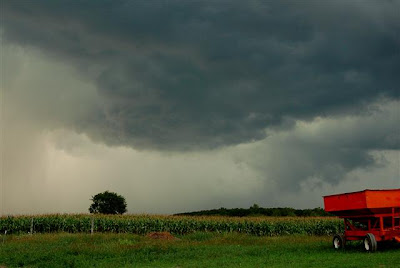
August 12, 2007
Oxford, Michigan
Photographer states :: Coming Storm !
This is a similar storm as the one from New York, which is about the same latitude, only in this photo the down pour is to the left of the picture. The above picture is closer to the storm field than the one below, the one above also is in a different percipitation process, so they each have a different dimension of the same type of phenomena.

August 10, 2007
Hague, New York
Photographer states :: Excuse the rain on the lens...the cloud formation is spectacular! Believe it or not, the day turned out to be hot and sunny!
That is a center of a tropospheric vortex. I've seen them before at altitudes that low. Heat transfer system. That is where these 'rain/hail' downblasts come from.
Glacier Bay Weather
Elevation :: 33 ft / 10 m
Temperature :: 63 °F / 17 °C
Conditions :: Clear
Humidity :: 48%
Dew Point :: 43 °F / 6 °C
Wind :: 5 mph / 7 km/h / 2.1 m/s from the SE
Pressure :: 30.29 in / 1026 hPa (Steady)
Visibility :: 10.0 miles / 16.1 kilometers
UV :: 4 out of 16
Clouds :: Clear -
(Above Ground Level)
Aviation
Flight Rule :: VFR (PAGS)
Wind Speed :: 5 mph / 7 km/h / 2.1 m/s
Wind Dir :: 140° (SE)
Ceiling :: Unlimited