March 14, 2006.
Alanreed, Texas.
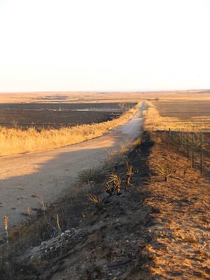
Photographer states :: Remnants and hot spots left from where a wildfire swept through this farmland in Texas last night. For about 25 miles for as far as the eye can see, the earth is scorched by fire.
Noted. Where there was no prairie grass of the roadway the fire literally jumped the manmade fire line sparing the prairie grass on each side of the road. Fascinating stuff. The updraft from the fire storm literally sucked the fire up and over the road. The road is not scorched and I believe that is a puddle at the bottom of the gully. A person could have stood in the middle of that roadway and been perfectly safe from ever catching on fire. I would not try that without flame retardant clothing, but, if I was ever caught in such a set of circumstances, you'd find me sitting down in the puddle looking and listening for any traffic.
