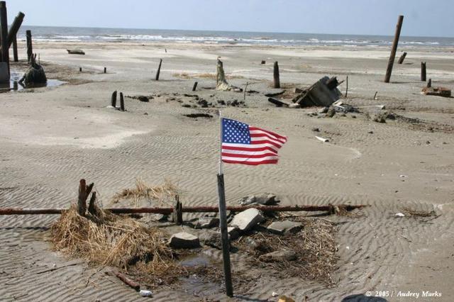
October 1, 2005. The family finally made it to the Beach House. The flag marks it's former place at Holly Beach, Louisiana at Breaux Bridge, La. This picture is sad enough but there is obviously no offshore wetlands to prevent this huge tidal surge. In addition, the 'sand' in this picture. Easily noted in the foreground. The sand has a 'rippling' through it. That pattern of 'rippling' is found in sand at the bottom of stagnant water. The water over this beach did not recede that quickly. It would have washed more of the beach away into the ocean if it immediately washed in and washed out. It tells me a lot about sea level rise. It tells me a lot about the length of the tidal surge of Rita. It tells me the 'side' of Rita that this beach received kept pushing water persistently to maintian a 'lagoo' until it passed. Rita was in no hurry to go inland as a result the persistent winds kept pushing the waters to the shore and created sustain presence long enough to begin to create an underwater ecosystem. When the storm finally passed the water receded into the ocean slower than one would think but with enough velocity to carry all the surface housing walls, boards and brick with it. It is this assessment that leads me to believe there was a curious dynamics with both Rita and Katrina that also would bring whirlpools with it as the water receded. It's a very strange picture. Very strange.
