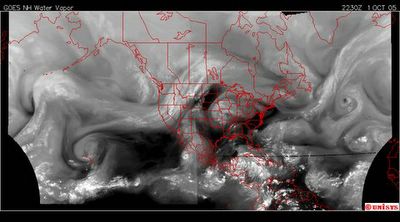
October 1, 2005. The burgeoning storms. This is somewhat predictable. I have seen this 'resolve' of the troposphere several times now both in last year and this year storm season. As soon as the 'major' storm of focus resolves and in this case it was "Rita" there is the beginning of the manifestation of the NEXT. The 'area' of this season's storms that are spawning the storms is the 'hotter' water between Haiti and Honduras. The notable vortices are narly in a straight line but not exactly the same latitudes as the storm known as "Hurricane Kenneth" dissipated and turned into a vortex as the heat resulting in the low pressure system had not completely resolved so much as transferred into a tropospheric event rather than a ocean event. "Hurricane Otis" is noted here. The two burgeoning storms in the Gulf are only beginning as Tropical Depressions 19 and 20. The most interesting aspect of this satellite picture is the return of the Jet Stream to latitudes about 45 north. The solar radiaiton is moving to the southern hemisphere and while there is an increase in 'darkness' in falling hours of daylight and less direct 'sun' the votices are diminished enough in this picture to allow the Jet Stream ot take prominence. This was an event much earlier in the year and was very brief, approximately 12 hours out of a day but it was hopes that it was a clear indication the CO2 level might be falling enough to resolve the votices dynamics and return normal dynamics back to Earth. It looks like that may be the trend regardless how 'brief' these manifestations are. The frequency they occur and the interval at which they occur will clearly indicate a trend of a return to a normal troposphere or not. It is my estimate as it has been the entire time that as soon as the CO2 levesl fell below 2002 levels the vortex dynamics woud resolve. I still feel that is the case and a very achievable goal.
