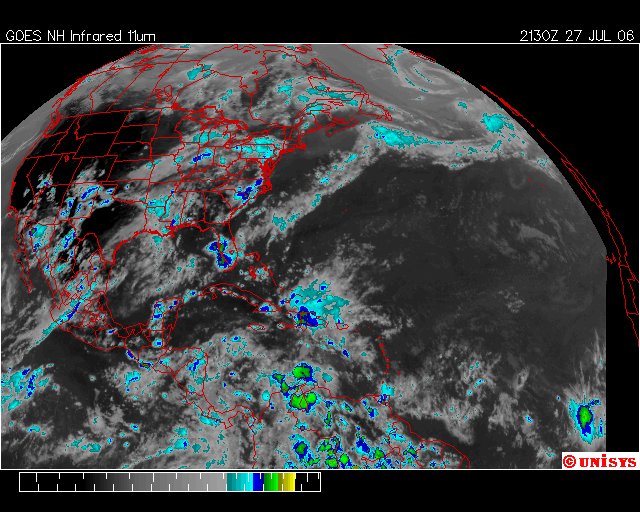
July 27, 2006.
2130z.
Unisys Enhanced Infrared Satellite.
I think we have a 'Model Year of 1998' to look at. Granted it isn't the same because of the vortices being chronic in the trophosphere but there are some very interesting similarities.
There was a terrible drought in 1998 and I didn't DECIDE on this year frivilously. Remember that as this unfolds.
Drought Indicators March 1998 (Click On)
As of the end of February, the Palmer Drought Severity Index (PDSI) indicated there are no areas which meet a drought condition as defined by the Drought Monitoring Task Force. Winter precipitation statewide is currently 124% of normal. Two areas indicating less than normal precipitation for the months of December through February include the extreme northwest corner of the state, and north central New Mexico.
Drought Indicators June 1998 (Click on)
Based on the information reviewed at the June 11, 1998 drought monitoring committee meeting, no areas in the state of New Mexico meet the drought definition as defined by the drought monitoring committee. According to the palmer index however, several climate divisions have experienced rapid drying conditions over the past few weeks. These divisions include 1, 2, 3, 7, and 8.
DROUGHT CONDITIONS FOR NEW MEXICO RELEASED (Click on)
JULY 24, 1998 - SANTA FE, NM
The Governor of New Mexico, through his New Mexico Drought Task Force and Drought Monitoring Group, has been closely monitoring the status of drought conditions in New Mexico. The Task Force and its Assessment Groups have completed a New Mexico Drought Plan, with various stages of drought mitigation and response actions in place and operating at this time.
This Plan outlines the actions to be taken by various state, federal, and local agencies to mitigate the effects of drought on the State of New Mexico.
At the present time, due to the lack of current adequate rainfall and the forecast by the National Climate Prediction Center of below normal precipitation for the next several months, the Drought Task Force is issuing a DROUGHT ALERT (Mild – Moderate Drought Conditions) for all or portions of the following New Mexico counties:
Colfax, Union, Quay, Curry, Mora, San Miguel, Guadalupe, Curry, Roosevelt, De Baca, Chaves, Eddy, Lincoln and Lea.
In addition, the Drought Task Force has issued a DROUGHT ADVISORY (Approaching Drought Conditions) for all or portions of the following counties:
McKinley, San Juan, Cibola, Sandoval, Taos, Rio Arriba, and Santa Fe
State and federal agencies in the ALERT counties have already begun to implement actions outlined in the NM Drought Plan, and residents will be kept informed of recommended actions to be taken through future news releases and public service announcements.
On July 27th the first named storm of the 'hurricane season' manifested. It was Tropical Storm Alex manifesting as a Tropical Depression at sustained 28 mph winds at 11.50 north latitude and 27.00 west longitude. It would sustain until August 3 having reached only 51.78 mph.
DROUGHT INDICATORS - August 1998 (Click on)
AS of the end of July, the division 7 PDSI had been below -2.00 for two consecutive months. The division 3 PDSI had been below -2.0 for one month. Strictly going by the drought plan triggering mechanisms, this places division 7 in the Warning category, and division 3 in the Alert category. Divisions 1 and 2, which had been placed in the Advisory status, had returned to "normal", although on the dry side.
Division 3 had been on a slight "improving" trend, although July precipitation totals suggest that most of the southern portion of division 3 remains extremely dry...
Division 7 is not improving, and the weekly PDSI suggests the severe drought that has been over Texas now extends into....
...The Weekly Ag. Update is reporting cattle and sheep in mostly fair condition. Soil moisture conditions for the state is 21% very short, 31% short, 45% adequate, 3% surplus. Most of the dry soil moisture is reported to be in the northeast and southeast parts of the state.
The hurricane season would start late and there would be three severe storms that season. Two of them began in the Atlantic Ocean near Africa. The first was was "Bonnie" which started as a tropical depression at 16.00 north latitude and 51.00 west longitude. It manifested with winds at 35 mph on August 18, 1998.
"Bonnie" would make landfall after crossing the ocean at 31.00 north latitude and 76.50 west longitude over South Carolina on August 27, 1998 as a Cat 3 storm with sustained winds of 115 mph. (Click on for landfall loop)
This is "Bonnie" as it approaced landfall. (click on) The storm would first threaten North Carolina and then skid back to come in shore over South Carolina.
DROUGHT INDICATORS - September 1998 (Click on)
As of the end of August, New Mexico climate divisions 3 and 7 were in the Warning category. Division 3 had experienced a monthly average PDSI between -2 and -3 for two consecutive months, wile the monthly PDSI for Division 7 had been -2 and -3 for three consecutive months. Unless a widespread heavy rain event occurs before the end of September, Division 7 will be in the Emergency category by the end of the month.
Forecasts: The latest 13 month forecast from the Climate Prediction Center indicates the likelihood of below-normal precipitation and above-normal temperatures for New Mexico through the coming winter and spring 1999 seasons. This is based mainly on the development and intensification of La Nina conditions. This forecast is also consistent with the previous forecasts for the upcoming winter and spring.
continued ...
