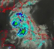
July 9, 2005. This is a satellite with a time of day 1230. At this point the hurricane was believed to have lost it's punch as it rolled over Cuba. Not so. The 'heat' distribution of these storms follow the 'path of least resistance.' The 'heat budget' of "Dennis" has not changed. The only change was the focus of it and the brief dissipating of the 'eye' to place it north of Cuba. In other words we are used to seeing hurricanes that have strong 'eyes' that maintain their idenitity in an 'eye' shaped storm. According to those standards we saw a hurricane nearly disappear. Not the case. "Dennis" literally placed a footprint on either side of Cuba without losing any of it's punch. Also note the leading edge of the outer bands and it's punch (royal blue color) compared to the hurricane itself. The entire heat budget OSCILLATED distributing the trauma over a larger SURFACE AREA. As it reached ocean waters again, the 'eye' came back as the focus for the rotation. This satellite picture shows a strong storm with minimally three intense areas which could deliver a great deal of damage in all areas with winds in the Cat 2 hurricane classification and Class 2 tornado classification. These are Global Warming Hurricanes and they occur 'without' eyes necessarily on Terra Firma as well.