QUETTA, Pakistan -- The death toll (click here) from a powerful earthquake that struck northwest Pakistan rose to at least 327 early Wednesday, authorities said.
The Pakistani military said it had rushed almost 1,000 troops to the area and was sending helicopters in the wake of Tuesday's temblor.
Most of the victims were killed when their houses collapsed. At least 350 people were injured....
This is not as much of a surprise as some might think. (click here) Pakistan is where land mammals were believed to evolve into whale species. There are fossil records to prove it. I am not very surprised to realize a land mass would rise to the surface, it wasn't all that deep to begin with. Pakistan needs to prevent people from entering the island until some archeologists can be found to explore the soils. There is also the possibility this is not a stable island so much as an opportunistic one. It is seismically dangerous.
That all changed with the discovery of a huge trove of fossils (click here) in central Asia (specifically, the country of Pakistan), some of which are still being analyzed and described. These fossils, which date from only 15 to 20 million years after the demise of the dinosaurs 65 million years ago, prove that the ultimate ancestors of whales were closely related to artiodactyls, the even-toed, hooved mammals represented today by pigs and sheep....
There are all kinds of geological structures in that area of the ocean, so the fact there was a huge displacement, probably subduction doesn't surprise me. I am sorry to hear so many people died.
 The rock doesn't look like basalt, so much as volcanic soil. However, there are some basaltic volcanos in the region, but, they are further south near the Mascarene Plateau.
I think there is a strong indication this seismic activity may have originated deep under India's coastal region.
Northwest Deccan Volcanic Province. It would make complete sense. The energy wave would have moved from the deep reaches of that volcanic layer across the Arabian Sea and into the very spot there was surface effects from it. I'd bet real money on it. I doubt anyone would change my mind about it without conclusive evidence.
This area of Earth is highly seismic due to the fact India is not attached to the Eurasian Plate. As a matter of fact the arrows in the picture below illustrate the chronic movement of India into the Eurasian continent. It is the mass of the continent that stops India from moving more north than it is. India came across the Indian Ocean to slam into the Eurasian Plate a long time ago. That is where the Himalayas came from. There was so much land mass displaced when these two huge land masses collided it pushed the lithosphere upward. There was no place else for it to go.
It all looks right to me.
Imprints of volcanism in the upper mantle beneath the NW Deccan volcanic province (click here)
This is not as much of a surprise as some might think. (click here) Pakistan is where land mammals were believed to evolve into whale species. There are fossil records to prove it. I am not very surprised to realize a land mass would rise to the surface, it wasn't all that deep to begin with. Pakistan needs to prevent people from entering the island until some archeologists can be found to explore the soils. There is also the possibility this is not a stable island so much as an opportunistic one. It is seismically dangerous.
That all changed with the discovery of a huge trove of fossils (click here) in central Asia (specifically, the country of Pakistan), some of which are still being analyzed and described. These fossils, which date from only 15 to 20 million years after the demise of the dinosaurs 65 million years ago, prove that the ultimate ancestors of whales were closely related to artiodactyls, the even-toed, hooved mammals represented today by pigs and sheep....
There are all kinds of geological structures in that area of the ocean, so the fact there was a huge displacement, probably subduction doesn't surprise me. I am sorry to hear so many people died.

I think there is a strong indication this seismic activity may have originated deep under India's coastal region.
Northwest Deccan Volcanic Province. It would make complete sense. The energy wave would have moved from the deep reaches of that volcanic layer across the Arabian Sea and into the very spot there was surface effects from it. I'd bet real money on it. I doubt anyone would change my mind about it without conclusive evidence.
This area of Earth is highly seismic due to the fact India is not attached to the Eurasian Plate. As a matter of fact the arrows in the picture below illustrate the chronic movement of India into the Eurasian continent. It is the mass of the continent that stops India from moving more north than it is. India came across the Indian Ocean to slam into the Eurasian Plate a long time ago. That is where the Himalayas came from. There was so much land mass displaced when these two huge land masses collided it pushed the lithosphere upward. There was no place else for it to go.
It all looks right to me.

Imprints of volcanism in the upper mantle beneath the NW Deccan volcanic province (click here)
Abstract
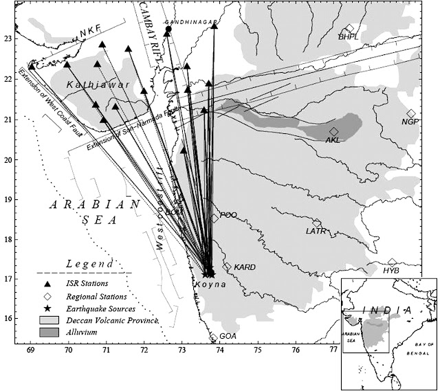
In this study, we investigate the transition zone discontinuities beneath the northwestern Deccan volcanic province of India through analysis of ∼1000 high-quality receiver functions abstracted from three-component teleseismic waveforms from 428 earthquakes recorded by six broadband stations in the northwestern Deccan volcanic province. Our analysis reveals that the P410s and P660s time lags are delayed by ∼1 s relative to those predicted by the IASP91 model. A largely unperturbed mantle transition zone, revealed by the transition zone time lag (tP660s – tP410s) of 23.83 s, implies that the observed delays are primarily associated with reduced shear velocities in the upper mantle above the 410 km discontinuity. The velocity reduction is likely to be associated with lithospheric thinning coupled with compositional and reduced thermal variations in the shallow upper mantle. Our results contrast with the normal shield-like velocity structure imaged beneath the south-central Deccan volcanic province in an earlier receiver function study. For comparison, a revised composite receiver function plot for the south-central Deccan volcanic province was constructed by employing identical receiver function processing techniques on an updated high-quality data set of 1400 receiver functions from 11 stations, which reaffirms, with better precision, the earlier results. We propose that the relative differences in the lithospheric thicknesses beneath the northwestern and south-central parts of the Deccan volcanic province possibly governed the melting and flow patterns of the upwelling mantle material, resulting in the contrasting seismic signatures. The lithospheric architecture of the northwestern Deccan volcanic province, coupled with the reactivation of preexisting rift systems, appears to have facilitated the eruption of the Deccan basalts, for which source signatures are still retained in the upper mantle.