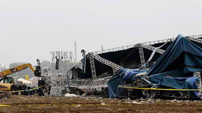
Indiana State Police (click title to entry - thank you) and authorities survey the collapsed rigging and Sugarland stage on the infield at the Indiana State Fair in Indianapolis, Aug. 14, 2011. Five people died in the stage collapse. (Darron Cummings/AP Photo)
From the reports about this tragedy, the wind was 'rolling' according to eyewitnesses.
"Speed Sheer" occurs before tornadic winds go from being on the ground to moving to an upright funnel cloud.
The crowd had no way of knowing or being warned the wind had the potential to turn their world into a threat of death.
 Speed shear is the change in wind speed with height. In the illustration below, the wind is increasing with height. This tends to create a rolling affect to the atmosphere and is believed to be a key component in the formation of mesocyclones which can lead to tornados.
Pilots sometimes see this in the sky as 'roll clouds.' Dust storms have this characteristic as they 'roll in' to an area.
The conditions were right for a turbulent wind event.
..."The weather changed in a matter of minutes and the stage collapsed in a matter of seconds. We are shocked and saddened by this horribly tragic circumstance and we are all praying for those affected," she wrote on her website, where she also recalled the events of the night as like "a bad dream."...
Under the best of circumstances, finding tornadoes to report is like finding a needle in a haystack. The USA Weather Service and NOAA radio do a remarkably good job of warning people as soon as there is any perceived danger. NOAA Radio has an aggressive methodology that begins with any hint of strong thunderstorms. It is a brilliant way of letting people know there is danger in the area related to unstable air masses.
When was the last time there has been simply drizzle or a steady, regular 'all day' rain in the USA? That reality is rarely heard of anymore. Rainbows come 'under cloud' banks in the sky where 'water vapor' is in the atmosphere; literally underneath dark storm clouds as the sun pokes through any break in the cloud bank. That used to be unusual as were double or the very rare triple rainbows. Now. It happens all the time. This climate is hot and dangerous. The water vapor is in the upper levels of the atmosphere and the heat is on the ground.
From the reports about this tragedy, the wind was 'rolling' according to eyewitnesses.
"Speed Sheer" occurs before tornadic winds go from being on the ground to moving to an upright funnel cloud.
The crowd had no way of knowing or being warned the wind had the potential to turn their world into a threat of death.
 Speed shear is the change in wind speed with height. In the illustration below, the wind is increasing with height. This tends to create a rolling affect to the atmosphere and is believed to be a key component in the formation of mesocyclones which can lead to tornados.
Pilots sometimes see this in the sky as 'roll clouds.' Dust storms have this characteristic as they 'roll in' to an area.
The conditions were right for a turbulent wind event.
..."The weather changed in a matter of minutes and the stage collapsed in a matter of seconds. We are shocked and saddened by this horribly tragic circumstance and we are all praying for those affected," she wrote on her website, where she also recalled the events of the night as like "a bad dream."...
Under the best of circumstances, finding tornadoes to report is like finding a needle in a haystack. The USA Weather Service and NOAA radio do a remarkably good job of warning people as soon as there is any perceived danger. NOAA Radio has an aggressive methodology that begins with any hint of strong thunderstorms. It is a brilliant way of letting people know there is danger in the area related to unstable air masses.
When was the last time there has been simply drizzle or a steady, regular 'all day' rain in the USA? That reality is rarely heard of anymore. Rainbows come 'under cloud' banks in the sky where 'water vapor' is in the atmosphere; literally underneath dark storm clouds as the sun pokes through any break in the cloud bank. That used to be unusual as were double or the very rare triple rainbows. Now. It happens all the time. This climate is hot and dangerous. The water vapor is in the upper levels of the atmosphere and the heat is on the ground.
