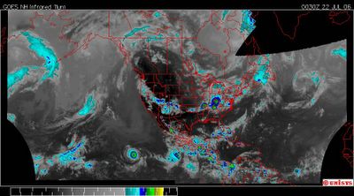
July 22, 2006.
0030z.
Enhanced Infrared Satellite of the Western and Northern Hemisphere.
The perfect circle at the equator is Hurricane Daniel. It is a Cat 4 storm with winds at 125 knots or approximately 144 mph. It is estimated to degrade to a tropical depression in about 120 hours.
Central America is taking a beating. There are chronic convection systems over nearly every nation there.
There is a very odd vorticity in nearly the same place for months now over the Central Atlantic. It's nearly impossible to discern it's nature in this satellite but when viewing the GOES East Satellite in a high resolution water vapor it is easily noted. It's primarily stationary and while the water vapor isn't consistent the vortex is. It seems to disappear and reappear from time to time but that is simply a flux in the water vapor content. A resident vortex over the Mid Atlantic most probably over the Mid-Atlantic Rigid. Most probably over an active area that has at it's very northern border the volcanic and seimic island of Iceland. 'Heat' A resident heat storm of the Mid Atlantic.
Hm.
